Loudonville, Ohio
- For the hamlet in New York, see Loudonville, New York.
Loudonville, Ohio | |
|---|---|
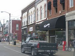
 Downtown Loudonville | |
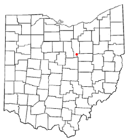
 Location of Loudonville, Ohio | |
| Country | United States |
| State | Ohio |
| Counties | Ashland, Holmes |
| Area | |
| • Total | 2.5 sq mi (6.5 km2) |
| • Land | 2.5 sq mi (6.4 km2) |
| • Water | 0.0 sq mi (0.0 km2) |
| Elevation | 965 ft (294 m) |
| Population (2000) | |
| • Total | 2,906 |
| • Density | 1,168.8/sq mi (451.3/km2) |
| Time zone | UTC-5 (Eastern (EST)) |
| • Summer (DST) | UTC-4 (EDT) |
| ZIP code | 44842 |
| Area code | 419 |
| FIPS code | 39-45066Template:GR |
| GNIS feature ID | 1061446Template:GR |
Loudonville is a village in Ashland and Holmes counties in the U.S. state of Ohio. The population was 2,906 at the 2000 census. Loudonville is nicknamed the "Canoe Capital of Ohio" for the many canoe liveries along the Mohican River. It is also home to Mohican State Park and Mohican-Memorial State Forest and Landoll's Mohican Castle.
History

Loudonville was founded on August 6, 1814, by James Louden Priest.
Loudonville was the long-time (1913–96) home of The Flxible Company, a manufacturer of motorcycle sidecars, commercial cars (hearses, ambulances, and flower cars), intercity coaches, and city-transit coaches. During World War II, Flxible interrupted its normal production and built instead a variety of war goods. A part of the former Flxible plant is now in use as a parts depot and service point for the Motor Coach Industries.
Geography
Loudonville is located at 40°38′9″N 82°13′59″W / 40.63583°N 82.23306°WInvalid arguments have been passed to the {{#coordinates:}} function (40.635850, -82.232959)Template:GR, along the Black Fork of the Mohican River.[1]
According to the United States Census Bureau, the village has a total area of 2.5 square miles (6.5 km²), of which 2.5 square miles (6.4 km²) is land, and 0.40% is water.
Demographics
As of the censusTemplate:GR of 2000, there were 2,906 people, 1,189 households, and 763 families residing in the village. The population density was 1,168.8 people per square mile (450.6/km²). There were 1,264 housing units at an average density of 508.4/sq mi (196.0/km²). The racial makeup of the village was 98.93% White, 0.03% Native American, 0.21% Asian, 0.17% from other races, and 0.65% from two or more races. Hispanic or Latino of any race were 0.52% of the population.
There were 1,189 households out of which 30.0% had children under the age of 18 living with them, 51.0% were married couples living together, 9.9% had a female householder with no husband present, and 35.8% were non-families. 31.5% of all households were made up of individuals and 13.9% had someone living alone who was 65 years of age or older. The average household size was 2.34 and the average family size was 2.94.
In the village the population was spread out with 24.6% under the age of 18, 6.6% from 18 to 24, 27.3% from 25 to 44, 22.9% from 45 to 64, and 18.5% who were 65 years of age or older. The median age was 39 years. For every 100 females there were 94.9 males. For every 100 females age 18 and over, there were 88.3 males.
The median income for a household in the village was $36,273, and the median income for a family was $42,500. Males had a median income of $31,225 versus $23,807 for females. The per capita income for the village was $16,831. About 9.7% of families and 13.2% of the population were below the poverty line, including 24.3% of those under age 18 and 5.0% of those age 65 or over.
Notable natives and residents
- Mary Crow - poet, professor
- Charles F. Kettering - inventor of the automobile self-starter
- Larry Siegfried - former basketball star at Ohio State University and the National Basketball Association's Boston Celtics
- Ron Zook - former head football coach at the University of Florida and current head coach at the University of Illinois
- Barbara Stadtlander - artist, teacher


