Islandia, Florida
Islandia, Florida | |
|---|---|
 Location in Miami-Dade County and the state of Florida | |
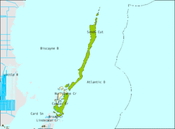
 U.S. Census Bureau map showing city limits | |
| Country | |
| State | |
| County | Miami-Dade |
| Area | |
| • Total | 66.4 sq mi (171.9 km2) |
| • Land | 6.5 sq mi (16.7 km2) |
| • Water | 59.9 sq mi (155.2 km2) |
| Elevation | 3 ft (1 m) |
| Population (2010) | |
| • Total | 18 |
| • Density | 0.27/sq mi (0.10/km2) |
| Time zone | UTC-5 (Eastern (EST)) |
| • Summer (DST) | UTC-4 (EDT) |
| FIPS code | 12-34175Template:GR |
| GNIS feature ID | 0304638Template:GR |
Islandia was a city in Miami-Dade County, Florida, United States, located on Totten Key south of Elliott Key. The population was 18 at the 2010 Census.[1] Since 2002, the city has not had an active government.[2]
History
This section contains wording that promotes the subject in a subjective manner without imparting real information. (May 2011) |
During the middle of the 20th century, the coral reef islands east of Homestead were seen as potential high income development. Monroe County was so certain that this would be the next boom area that it offered all of mainland Monroe County in exchange for these islands, but Dade County (now Miami-Dade County) declined the offer. At the same time, many Florida environmentalists were lobbying to avoid what happened to other sensitive areas in South Florida[peacock prose] happening to these sensitive coral reefs. The state legislature allowed the community to incorporate, but did not allow any further development until the issue could be resolved. As the decades passed, Islandia's chances of becoming a resort waned, and the laws to protect the reefs increased. Eventually Biscayne National Monument became Biscayne National Park and any hope of an Islandia boom disappeared. The city is still incorporated.[3][dead link]
Geography
Islandia is located at 25°23′18″N 80°14′10″W / 25.38833°N 80.23611°W (25.388299, -80.236180).Template:GR
According to the United States Census Bureau, the city has a total area of 66.4 square miles (171.9 km²). 6.4 square miles (16.7 km²) of it is land and 59.9 square miles (155.2 km²) of it (90.28%) is water.
Surrounding areas
- Biscayne Bay
- Biscayne Bay


 Atlantic Ocean
 - Biscayne Bay

 Atlantic Ocean
 - Key Largo


 Atlantic Ocean
 - Key Largo, Atlantic Ocean
Demographics
As of the census of 2000,Template:GR there were 6 people, 3 households, and 1 family residing in the city. The population density was 0.9 people per square mile (0.4/km²). There were 5 housing units at an average density of 0.8 persons/mi² (0.3 persons/km²). The racial makeup of the city was 100.00% White.
There are 3 households out of which 1 had children under the age of 18 living with them, 1 was a married couple living together, and 2 were non-families. 2 households were made up of individuals. The average household size was 2.00 and the average family size was 4.00.
In the city the population was spread out with 2 under the age of 18, 2 from 25 to 44, and 2 from 45 to 64. The median age was 32 years. For every female there was 1 male. For every females age 18 and over, there was 1 male.
The median income for a household in the city was $41,875, and the median income for a family was $80,488. Males had a median income of $41,875 versus $0 for females. The per capita income for the city was $27,000. None of the population was below the poverty line.
References
- ^ "See "Population and Housing Occupancy Status: 2010 - County -- County Subdivision and Place" for Florida". 2010 Census. United States Census Bureau, Population Division.
{{cite web}}: Cite has empty unknown parameter:|1=(help) - ^ U.S. Census Bureau Geographic Change Notes (2007)
- ^ Islandia - MiamiHerald.com

