
Western Ghats

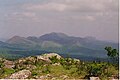
The Western Ghats are a mountain range in India. They run along the western edge of the Deccan Plateau, and separate the plateau from a narrow coastal plain along the Arabian Sea. The range starts south of the Tapti River near the border of Gujarat and Maharashtra, and runs approximately 1600 km through the states of Maharashtra, Goa, Karnataka, Kerala, and Tamil Nadu, to Cape Comorin or Kanyakumari, the southern tip of the Indian peninsula. The average elevation is around 900 meters. This range is also known as the Sahyadri mountains in Maharashtra and north Karnataka and Malabar region in Kerala.

Mountain range
Higher peaks occur in the northern section of the range in Maharashtra, notably Kalsubai 1646 m (5427 ft), Mahabaleshwar 1438 m (4710 ft) and Harishchandragarh 1424 m (4691 ft); in southwest Karnataka, notably Kudremukh at 1862 m (6,109 ft) and Mullayanagiri at 1925 m (6,317 ft); and in the southern part of the range, with Anai Mudi in Kerala at 2695 meters (8,842 ft) being the highest peak in the Western Ghats. Chembra Peak in Kerala at 2100 m, Banasura Peak in Kerala at 2073 m and Vellarimala in Kerala at 2200 meters. The only major gaps in the range are the Goa gap, between the Maharashtra and Karnataka sections, and the Palghat Gap that joins Tamil Nadu to Kerala. Smaller ranges, including the Nilgiri Hills (with Doddabetta being the highest peak at 2623 meters) of northwestern Tamil Nadu and Biligirirangans southeast of Mysore in Karnataka, meet the Shevaroys (Servarayan range) and Tirumala range farther east, linking the Western Ghats to the Eastern Ghats. These hill ranges serve as important wildlife corridors, allowing species like elephants to move seasonally between the ranges.
The northern portion of the narrow coastal plain between the Western Ghats and the Arabian Sea is known as the Konkan Coast or simply Konkan, and the southern portion is called Malabar region or the Malabar Coast. The foothill region east of the Ghats in Maharashtra is known as Desh, while the eastern foothills of central Karnataka state is known as the Malnad region. The largest city within the mountains is the city of Pune, in the Desh region on the eastern edge of the range.
The mountains intercept the rain-bearing westerly monsoon winds, and are consequently an area of high rainfall, particularly on their western side. The dense forests also contribute to the precipitation of the area by acting as a substrate for condensation of moist rising (orographic) winds from the sea, and releasing much of the moisture back into the air via transpiration, allowing it to later condense and fall again as rain.
The westward-facing slopes receive much more rain than the eastward-facing slopes, and the Western Ghats are considerably wetter than the dry Deccan to the east. The Western Ghats form the most important watershed for peninsular India, the plentiful rain giving rise to numerous streams and rivers such as the Chittar River with many waterfalls, Manimuthar River, Pachaiyar River and the Tambaraparani River, form the headwaters of both the short rivers that run to the Arabian Sea and the great perennial rivers of the Deccan, including the Godavari River, Krishna River, Kaveri River and their tributaries, which empty into the Bay of Bengal.
These rivers provide the water for agriculture and drinking to all the major cities downstream including the cities of Bangalore, Pune and Mumbai. Many of these rivers and streams are threatened by pollution from mining, agricultural and urban runoff, coffee pulp effluents and other human activity. There has recently been a strong movement to curb mining operations in the Western Ghats, as this is one of the global Biodiversity hotspots. The Kudremukh region was once mined for iron and the Kali river was used to transport ore.

Rain Forests

Historically the Western Ghats were well-covered in dense forests. They contain the largest patches of moist deciduous forest and rain forest in southern India. These forests are home to diverse fauna and flora, many of them showing affinities to the Malayan region, but are increasingly threatened by human activity. Several national parks and other protected areas lie within the range, but it is estimated that only a small fraction of the Western Ghats remains in pristine condition. The Silent Valley National Park in Kerala is considered by many to be the last tracts of virgin tropical evergreen forest in India.
Flora and Fauna

Biogeographers have long recognized the distinctive plant and animal communities of the Western Ghats. Many of these faunal and floral elements are not found anywhere else in India except in parts of northeastern India. The Western Ghats are also home to many endemic species, and the endemism is especially high in the amphibian and reptilian fauna. The snake family Uropeltidae is almost entirely restricted to and diversified in this region of the world. The frog Nasikabatrachus sahyadrensis was discovered in 2003 as being a living fossil. This species of frog is most closely related to species found in the Seychelles. Some Western Ghats streams are home to a freshwater puffer fish Carinotetraodon travancoricus apart from marine forms like Chelonodon patoca (Buchanan-Hamilton,1822) [1].
The Western Ghats are ecologically distinct from the drier regions to the north and east, but can be further divided into four ecoregions. The northern portion of the range is generally drier than the southern portion, and at lower elevations makes up the North Western Ghats moist deciduous forests ecoregion, with mostly deciduous forests made up predominantly of teak (Tectona grandis) and dipterocarps. Above 1000 meters elevation are the cooler and wetter North Western Ghats montane rain forests, whose evergreen forests are characterized by trees of family Lauraceae. The northern portion of the ghats is found in the states of Goa, Maharashtra and Gujarat.

The evergreen Wayanad forests of Kerala mark the transition zone between the northern and southern ecoregions of the Western Ghats. The southern ecoregions are generally wetter and more species-rich. At lower elevations are the South Western Ghats moist deciduous forests, with Cullenia is the characteristic tree genus, accompanied by teak, dipterocarps, and other trees. These moist forests transition to the drier South Deccan Plateau dry deciduous forests to the east, in the mountains' rain shadow. Above 1000 meters are the South Western Ghats montane rain forests, also cooler and wetter than the surrounding lowland forests, and dominated by evergreen trees, although some montane grasslands and stunted forests can be found at the highest elevations. The South Western Ghats montane rain forests are the most species-rich ecoregion in peninsular India; eighty percent of the flowering plant species of the entire Western Ghats range are found in this ecoregion. It also harbors the highest levels of endemism: around 35 % of the plants, 42 % of the fishes, 48 % of the reptiles, and 75 % of the amphibians that live in this ecoregion are endemic. Still higher, above elevations of 1600 m MSL are seen the shola-grassland mosaic, which are habitats exclusive to the Western Ghats.
One of the endemic species of the Western Ghats is the Lion-tailed Macaque. There are only 4000 of this species remaining in the Western Ghats. A study of these monkeys suggests that the health of their population depends on a continuous canopy and a break in the canopy of more than 0.5 km² hinders the movement of these animals.[citation needed]
Distinct ranges
Western Ghats of Maharashtra
The Western Ghats of Maharashtra spreads from the Satpura range to the north, and continues south past Goa to Karnataka. The major hill range of the sector is sahyadr hil range. One can not avoid the awsome hill station like Mahabaleshar and Panchgani. Five rivers emerge out from Mahabaleshwar viz. Krishna, Koyana, Venna, Savitri and saraswati. The semi-deciduous forest of Mahabaleshwar is rich with flora and fauna.The giant squirrel, the state animal of Maharashtra is found in the dense forest,here. Panchagani is located on skirtings of ravines. It is an educational centre as more than 26 resedential schools are located here. The table land, here, is the largest table land in India. If Tibet is the roof of the world, Panchagani is the Roof of India.
There are many forts in this region built prior to 1500 AD. Many of these forts were built by Shivajiraje Bhosle. These include Raigad, Rajgad, Torana, Pratapgad and Panhala. Some of these are tourist attractions.
There are many dams in this region. One among the first hydroelectric power station in India was started by Tata in the early 1900s near Khopoli, a town near Lonawala . It is still functional.
Western Ghats of Goa
This section needs expansion. You can help by adding to it. |
Western Ghats of Karnataka
-
 Bhadra Reservoir and Ghats Chikmagalur
 -
 Bhadra WLS Chikmagalur, Karnataka
 -
 Panorama view, Biligirirangan Hills WLS Chamarajanagar
 -
 Sunrise, Biligirirangan Hills WLS Chamarajanagar


About sixty percent of the Western Ghats are located in the state of Karnataka. Most of Karnataka's five hundred species of birds are from the Western Ghats region.[citation needed] The evergreen forests of Nagarahole, deciduous forests of Bandipur National Park and Nugu in Karnataka and adjoining regions of Wayanad and Mudumalai National Park in the states of Kerala and Tamil Nadu form the single largest protected area in the Western Ghats system comprising some 5500 km². This is also called the Nilgiri Biosphere Reserve.
This is home to the largest population of the Asian Elephant and forms an important "Project Elephant" and "Project Tiger" reserve. The Karnataka's ghats are home to over six thousand elephants (as of 2004). The largest population of tigers outside the Sundarbans ecosystem is also believed to be found here. The largest numbers and herds of Gaur are found here with the Bandipur National Park and Nagarahole together holding over five thousand Gaur.
The Biligirirangan Hills lies at the confluence of the western and Eastern Ghats and is home to unique ecosystems present in both ranges. It is an important butterfly migration area[citation needed] and has also been eulogised in poetry and music. Karnataka's Ghat areas holds about twenty five percent of all asiatic elephants and ten percent of India's tiger population.
North of this region is the Kudremukh national park in the central region of Karnataka's western ghats. Kudremukh National Park has one of the most beautiful landscapes in the Western Ghats, encompassing evergreen, semi-evergreen and grassland shola habitat characteristic of high altitude Western Ghats regions. This park protects a viable population of Lion tailed macacque.
To the west are the forests of Kodagu which hold sizeable populations of the endangered Nilgiri Langur and have numerous bird species. Brahmagiri and Pushpagiri wildlife sanctuaries are important elephant habitat. Talakaveri wildlife sanctuary is a critial watershed and the source of the river Kaveri. This region has dense evergreen and semi-evergreen vegetation, with shola-grassland in areas of higher elevation. The steep terrain of the area has resulted in scenic waterfalls along its many mountain streams.
Bhadra Wildlife Sanctuary and project tiger reserve in Chikmagalur has large populations of Indian muntjac. This is an excellent birding region. Since it is located at the northern end of the Malabar ranges and the southern tip of the Sahyadri ranges, bird species from both ranges can be seen here. Large colonies of Parrots are common here.
Sharavathi and Someshvara Wildlife sanctuaries in Shimoga district are the source of the Tungabhadra river system and are known habitat of the Indian King Cobra. The first hydroelectric power station in India was designed by Sir M. Vishweshwaraiah near the Jog Falls and is named after Mahatma Gandhi.
Bannerghatta National park and reserve forest of Annekal close to Bangalore are an important elephant corridor connecting the forests of Tamil Nadu with those of Karnataka.
Dandeli and Anshi national parks in Uttara Kannada district are home to the Black Panther and normal variety of leopards and significant populations of Great Indian Hornbill. These large birds congregate even near human habitation inside the park regularly. Bhimgad in Belgaum district is a proposed wildlife sanctuary and is home to the endemic Wroughton's freetailed bat (Otomops wroughtoni), the Krishnapur caves close by are one of only three places in the country where the little-known Theobald's tomb bat (Taphozous theobaldi) is found. The rare Megaderma spasma bats are found in the Talevadi caves. Karnataka's ghats are also the home to several scenic waterfalls including the Jog falls. With the exception of four wildlife sanctuaries, all the remaining 22 national parks and wildlife sanctuaries of Karnataka are located in the Western Ghats, either at the evergreen higher elevations or deciduous lower elevation regions.
Western Ghats of Tamil Nadu
This section needs expansion. You can help by adding to it. |
Western Ghats of Kerala
Running along the western edge of Kerala, except for a gap of about 30 kilometers width called the Palakkad Gap (also known as Palghat Gap) near the town of Palakkad (Palghat), the Western Ghats form the western border of the state.
Western Ghats in Kerala is home to tea and coffee plantations, reserved forests, and dense tropical jungles. Elephant, Gaur, Sambar, and Wild Boars dwell in the forests. Sloth Bear, Leopard and tiger are also found. The Western Ghats in Kerala is home to numerous serene hill stations like Munnar, Ponmudi, Waynad etc. The famous Silent Valley National Park also falls under the Western Ghats.
This section needs expansion. You can help by adding to it. |
References
- Wikramanayake, Eric; Eric Dinerstein; Colby J. Loucks; et. al. (2002). Terrestrial Ecoregions of the Indo-Pacific: a Conservation Assessment. Island Press; Washington, DC.
- Trek the Sahyadris Harish Kapadia