
Dalmatia

Dalmatia (Croatian : Dalmacija, Italian: Dalmazia) is a region on the eastern coast of the Adriatic Sea, in modern Croatia, spreading between the island of Rab in the northwest and the Gulf of Kotor (Boka Kotorska) in the southeast. The hinterland, Inner Dalmatia (Zagora), ranges from fifty kilometers in width in the north but narrows to just a few kilometers wide in the south.
Croatian Dalmatia is currently composed of four counties, the capital cities of which are Zadar, Šibenik, Split and Dubrovnik. Other larger cities in Dalmatia include Biograd, Kaštela, Sinj, Solin, Omiš, Knin, Metković, Makarska, Trogir, Ploče, Trilj and Imotski.
The larger Dalmatian islands are Dugi Otok, Ugljan, Pašman, Brač, Hvar, Korčula, Vis, Lastovo and Mljet. The larger Dalmatian mountains are Dinara, Mosor, Svilaja, Biokovo, Moseć and Kozjak. The rivers are Zrmanja, Krka, Cetina and Neretva.
Because of the way sea currents and winds flow, the sea water of the Adriatic is cleaner and warmer on the Croatian side than it is on the Italian side.[citation needed] The Dalmatian concordant coastline also includes an immense number of coves, islands and channels. This makes it an attractive place for nautical races, and nautical tourism in general. There's also a good number of marinas.
Dalmatia also includes several national parks that are tourist attractions: Paklenica karst river, Kornati archipelago, Krka river rapids and Mljet island within island.
Definitions
The historical region of Dalmatia was much larger than the present-day Dalmatia. Dalmatia signified not only a geographical unit, but it was an entity based on common culture and settlement types, a common narrow eastern Adriatic coastal belt, Mediterranean climate, sclereophyllus vegetation of the Illyrian vegetation province, Adriatic carbonate platform, and karst geomorphology.
Among other things, the ecclesiastical primatical territory today continues to be larger because of the history: it includes part of modern Montenegro (another former republic of Tito's Yugoslavia), notably around Bar (Antivari), the (honorary) Roman Catholic primas of Dalmatia, but an exempt archbishopric without suffragans while the archbishoprics of Split (also a historical primas of Dalmatia) has provincial authority over all Croatian dioceses except he exempt archbishopric of Zadar.
The southernmost transitional part of historical Dalmatia, the Gulf of Kotor is not part of present-day Croatian Dalmatia, but part of Montenegro. The regional coherent geographical unit of historical Dalmatia, the coastal region between Istria and the Gulf of Kotor, includes the Orjen mountain whose peak at 1894 m is the highest point, even if it is part of Montenegro. If we take present-day Dalmatia only as a geographical unit, the highest peak would be Dinara (1913 m) which is not a coastal mountain. On the other hand, Biokovo (Sv. Jure 1762 m) and Velebit (Vaganjski vrh 1758 m) are coastal Dinaric mountains but not as high as Orjen. In the tectonical sense, Orjen is the highest mountain of austro-hungarian province Dalmatia, while Biokovo is the highest mountain of the administrative unit of Split-Dalmatia county.
History
Classical antiquity

Dalmatia is a region with a long history. Its name is probably derived from the name of an Illyrian tribe called the Dalmatae which lived in the area of the eastern Adriatic coast in the 1st millennium BC. It was part of the Illyrian kingdom between the 4th century BC until the Illyrian Wars in the 220s BC and 168 BC when the Roman Republic established its protectorate south of river Neretva. Area north of Neretva was slowly incorporated until province Illyricum was formally established c. 32-27 BC
Dalmatia then became part of the Roman province of Illyricum. In AD 6-9 9 AD, the Dalmatians raised the last in a series of revolts together with the Pannonians, but it was finally crushed and in 10 AD Illyricum was split into two provinces, Pannonia and Dalmatia. The province of Dalmatia spread inland to cover all of the Dinaric Alps and most of the eastern Adriatic coast. Dalmatia was later the birthplace of the Roman Emperor Diocletian.
After the Western Roman Empire collapsed in 476, with the beginning of the Migration Period, the region was ruled by the Goths up to 535, when Justinian I added it to the Eastern (Byzantine) Empire.
Middle Ages
Rivalry of Croatia, Venice, Byzantium, and Hungary
The Republic of Venice made several attempts to attain control of the Dalmatian islands and city-states, while Byzantium also preserved an influence on them, although one which faded towards the end of the eleventh century, by which time the Kingdom of Hungary also expanded its influence southwards by subduing Croatia to Hungarian rule.
The 13th, 14th and 15th centuries were marked by a rivalry of Venice and Hungarian kingdom, as the Byzantine influence had fully faded.
In 1346, Dalmatia was struck by the Black Death. The economic situation was also poor, and the cities became more and more dependent on Venice. During this period Dalmatia was briefly ruled by Croatian magnates Šubić[citation needed], the first Bosnian kings , and contested by the Angevins and Sigismund, Holy Roman Emperor in the early 15th century, but the end result of this conflict was that the Venetians took control of most of Dalmatia by 1420.
Republic of Dubrovnik and Ottomans conquests

The southern city of Dubrovnik had managed to achieve complete independence as the Republic of Dubrovnik, and preserved it despite the numerous foreign invasions. The Ottoman wars in Europe had started affecting the area in the mid-15th century, and when the Venetian and Ottoman frontiers met, border wars became incessant. The Turks took control of much of the hinterland, and helped the Republic of Dubrovnik maintain its independency, but under their suzerainty. The Ottoman invasion further contributed to the inclusion of the Croats in the cities.
After the expansion of the Ottoman Empire was finally contained in the Great Turkish War at the turn of the 18th century, Dalmatia experienced a period of certain economic and cultural growth in the 18th century, as the trade routes with the hinterland were reestablished in peace. Christians also migrated from the Ottoman-held territory into the Christian-ruled Venice.
Modern Times
Napoleonic France and Austria-Hungary
This period was abruptly interrupted with the fall of the Republic of Venice in 1797. Napoleon's troops stormed the region and ended the independence of the Republic of Ragusa as well, but saving it from the occupation of Russian Empire and Montenegro. Napoleon's rule in Dalmatia was marked with many wars, which caused many rebellions. On the other side, French rule contributed a lot to Croat national awakening - first newspaper in Croatian language were issued then, in Zadar ("Kraglski Dalmatin"). French rule brought a lot of improvement in infrastructure; many roads were built or reconstructed. Napoleon himself blamed marechal Marmont, the governor of Dalmatia, that too much money was spent on Dalmatia.
By 1815, Dalmatia was taken by the Austrian Empire. After the Revolutions of 1848, the Croatian population of Dalmatia increasingly urged unification with Croatia (as it was after the fall of Venetian Republic, see the request of general Rukavina) which was controlled by the Hungarian (Transleithania) part of the then Austro-Hungarian Empire.
After 1918
In the First World War, the Austrian Empire disintegrated, and Dalmatia was again split between the Kingdom of Serbs, Croats, and Slovenes (later the Kingdom of Yugoslavia) which controlled most of it, and the Kingdom of Italy which held small portions of northern Dalmatia around Zadar.
In 1922, the Dalmatia region was divided into two provinces, the District of the City of Split (Splitska oblast), with capital in Split, and the District of the City of Dubrovnik (Dubrovačka oblast), with capital in Dubrovnik.
In 1929, the Maritime Banovina ("Primorska Banovina"), a province of the Kingdom of Yugoslavia was formed. Its capital was Split, and it included most of Dalmatia and parts of present-day Bosnia and Herzegovina. Southern parts of Dalmatia were in Zeta Banovina, from the Gulf of Kotor to Pelješac peinsula including Dubrovnik.
In 1939, the Maritime Banovina was joined with Sava Banovina to form new province named the Banovina of Croatia. In 1939, ethnic Croat areas of the Zeta Banovina from the Gulf of Kotor to Pelješac including Dubrovnik were merged with a new Banovina of Croatia.
During World War II, Fascist Italy occupied the entire region together with Nazi Germany, but after the end of the war Dalmatia was restored to Second Yugoslavia.
Dalmatia was divided between three federal republics of Yugoslavia - almost all of the territory went to Croatia, leaving the Gulf of Kotor to Montenegro and a small strip of coast at Neum to Bosnia and Herzegovina. When Yugoslavia dissolved in 1991 the republic borders became country borders as they are now.
Postage stamps
Italy issued special postage stamps for the part of northern Dalmatia it had occupied during World War I, necessitated by the locals' use of Austrian currency. The stamps were produced as surcharges of Italian stamps; the first appeared 1 May 1919, and consisted of the Italian 1-lira overprinted "una / corona".
5c and 10c overprints were issued in 1921, reading "5[10] / centesimi / di corona", followed by an additional five values in 1922. Similar overprints were made for special delivery and postage due stamps.
Soon after the annexed territories switched to Italian currency and stamps. As a result, usage was uncommon and validly-used stamps are today worth about 50-100% more than unused. They are easily confused with the Italian issues used in occupied Austria; the Dalmatian overprints are distinguished by their use of a sans serif typeface.
Gallery
-
 Narodni Trg (Pjaca) in Split
 -
 Split Harbour
 -

-
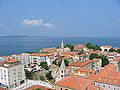 Panoramic view of Zadar
 -
 Roman Forum in Zadar
 -
 Summer on the street in Krapanj
 -
 Panoramic view of Hvar
.JPG)


.PNG)