Jamner
Appearance
This article needs additional citations for verification. (October 2015) |
Jamner | |
|---|---|
town | |
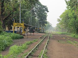
 Jamner Railway Station Photo | |
| Coordinates: 20°48′34″N 75°46′46″E / 20.80944°N 75.77944°E | |
| Country | |
| State | Maharashtra |
| District | Jalgaon |
| Government | |
| • Body | Municipal Council, Jamner |
| Elevation | 258 m (846 ft) |
| Population (2011) | |
| • Total | 46,762 |
| Demonym | Jamnerkar |
| Language | |
| • Official | Marathi |
| Time zone | UTC+5:30 (IST) |
| PIN | 424206 |
| Telephone code | + 91 2580 |
| Vehicle registration | MH-19 |
| Nearest city | Jalgaon 35km Bhusawal 26km |
| Lok Sabha constituency | Raver |
| Vidhan Sabha constituency | Jamner |
| Civic agency | Municipal Council, Jamner |
Jamner is a town in Jalgaon district of Maharashtra.it is administrative center of Jamner taluka.
Education Facilities
Politics
Girish Mahajan of BJP is sitting MLA of Jamner constituency.he was minister for Water resources, Medical Education and Irrigation of Maharashtra during Fadnavis government.BJP dominated this constituency due to Girish Mahajan's wining sprees.
Demographics
See also
References
- ^ "Population by religion community - 2011". Census of India, 2011. The Registrar General & Census Commissioner, India. Archived from the original on 25 August 2015.

