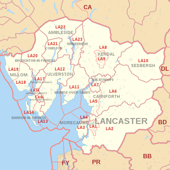
LA postcode area
Appearance
Postcode district boundaries:
KML is from Wikidata
Lancaster | |
|---|---|
| Coordinates: 54°10′23″N 2°54′25″W / 54.173°N 2.907°W | |
| Country | United Kingdom |
| Postcode area | LA |
| Postcode area name | Lancaster |
| Post towns | 17 |
| Postcode districts | 23 |
| Postcode sectors | 66 |
| Postcodes (live) | 11,800 |
| Postcodes (total) | 14,678 |
| Statistics as at May 2020[1] | |
The LA postcode area, also known as the Lancaster postcode area,[2] is a group of 23 postcode districts in north-west England, within 17 post towns. These cover north Lancashire (including Lancaster, Morecambe and Carnforth), south Cumbria (including Barrow-in-Furness, Kendal, Ulverston, Windermere, Dalton-in-Furness, Millom, Milnthorpe, Sedbergh, Grange-over-Sands, Askam-in-Furness, Kirkby-in-Furness, Broughton-in-Furness, Coniston and Ambleside) and a small part of North Yorkshire.
Coverage
The approximate coverage of the postcode districts:
Map
KML is from Wikidata

See also
References
- ^ "ONS Postcode Directory Version Notes" (ZIP). National Statistics Postcode Products. Office for National Statistics. May 2020. Table 2. Retrieved 19 June 2020. Coordinates from mean of unit postcode points, "Code-Point Open". OS OpenData. Ordnance Survey. February 2012. Retrieved 21 April 2012.
- ^ Royal Mail, Address Management Guide, (2004)
- ^ "New sectors and localities to 16 November 2012" (PDF). Royal Mail Address Management Unit. 19 November 2012. Retrieved 29 November 2012.[permanent dead link]

