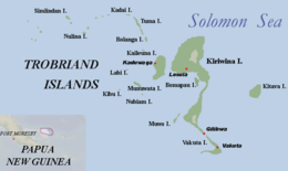
Kitava
 | |
 | |
| Geography | |
|---|---|
| Location | Solomon Sea |
| Coordinates | 8°37′20″S 151°20′04″E / 8.62222°S 151.33444°E |
| Archipelago | Trobriand Islands |
| Adjacent to | Pacific Ocean |
| Major islands | Kitava, Kiriwina, Kaileuna, Vakuta |
| Administration | |
| Province | Milne Bay Province |
| Additional information | |
| Time zone | |
Kitava is one of the four major islands in the Trobriand Islands archipelago group of the Solomon Sea, located in Milne Bay Province of southeastern Papua New Guinea.
Ethnography
The inhabitants of this island and their diet and lifestyle have been the subject of study by researcher Staffan Lindeberg and his colleagues, due to their reported excellent health and traditional diet. Lindeberg et al. have published several works in peer-reviewed journals outlining their discoveries.[1]
See also
Notes
- ^ "TheKitavaStudy". Staffanlindeberg.com. Archived from the original on 2013-12-07. Retrieved 2013-12-07.
References
