Härgla
Appearance
Härgla | |
|---|---|
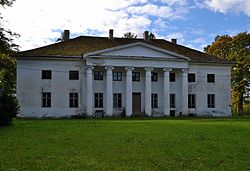
 Härgla manor main building | |
| Coordinates: 59°06′01″N 24°54′36″E / 59.10028°N 24.91000°E | |
| Country | |
| County | |
| Municipality | |
| First mentioned | 1241 |
| Area | |
| • Total | 12.35 km2 (4.77 sq mi) |
| Population (01.02.2010[1]) | |
| • Total | 68 |
| • Density | 5.5/km2 (14/sq mi) |
Härgla (also known as Härgküla) is a village in Juuru Parish, Rapla County, Estonia. It has an area of 12.35 km² and a population of 68 (as of 1 February 2010).[1]
In 2010 Kalda village was detached from the lands of Härgla.[2]
Härgla manor
Härgla manor (German: Herkül) is mentioned in written sources for the first time in 1516. The current building originally dates from the 1780s but has been extensively rebuilt. The façade is dominated by the large ionic portico. Remaining interior details are mostly late 19th century.[3]
See also
References
- ^ a b "Kohanimenõukogu koosoleku protokoll nr 34" (PDF) (in Estonian). EKI Place Names Board. p. 2.
- ^ "Changes in the list of populated places".
- ^ Sakk, Ivar (2004). Estonian Manors - A Travelogue. Tallinn: Sakk & Sakk OÜ. p. 81. ISBN 9949-10-117-4.

