
Fisherground railway station
Fisherground | |
|---|---|
| General information | |
| Location | Copeland, Cumbria |
| Coordinates | 54°23′31″N 3°18′13″W / 54.391970°N 3.303697°W |
| Owned by | R&ER |
| Managed by | R&ER |
| Line(s) | Ravenglass and Eskdale Railway |
| Key dates | |
| 1876 | Opened (3 ft gauge) |
| 1913 | Station closed |
| 1916 | Reopened (15 in gauge |
Ravenglass & Eskdale Railway | |||||||||||||||||||||||||||||||||||||||||||||||||||||||||||||||||||||||||||||||||||||||||||||||||||||||||||||||||||||||||||||||||||||||||||||||||||||||||||||||||||||||||||||||||||||||||||||||||||||||||||||||||||||||||||||||||||||||||||||||||||||||||||||||||||||||||||||||||||||||||||||||||||||||||||||||||||||||||||||||||||||||||||||||||||||||||||||||||||||||||||||||||||||||||||||||||||||||||||||||||||||||||||||||||||||||||||||||||||||||||||||||||||||||||||||||||
|---|---|---|---|---|---|---|---|---|---|---|---|---|---|---|---|---|---|---|---|---|---|---|---|---|---|---|---|---|---|---|---|---|---|---|---|---|---|---|---|---|---|---|---|---|---|---|---|---|---|---|---|---|---|---|---|---|---|---|---|---|---|---|---|---|---|---|---|---|---|---|---|---|---|---|---|---|---|---|---|---|---|---|---|---|---|---|---|---|---|---|---|---|---|---|---|---|---|---|---|---|---|---|---|---|---|---|---|---|---|---|---|---|---|---|---|---|---|---|---|---|---|---|---|---|---|---|---|---|---|---|---|---|---|---|---|---|---|---|---|---|---|---|---|---|---|---|---|---|---|---|---|---|---|---|---|---|---|---|---|---|---|---|---|---|---|---|---|---|---|---|---|---|---|---|---|---|---|---|---|---|---|---|---|---|---|---|---|---|---|---|---|---|---|---|---|---|---|---|---|---|---|---|---|---|---|---|---|---|---|---|---|---|---|---|---|---|---|---|---|---|---|---|---|---|---|---|---|---|---|---|---|---|---|---|---|---|---|---|---|---|---|---|---|---|---|---|---|---|---|---|---|---|---|---|---|---|---|---|---|---|---|---|---|---|---|---|---|---|---|---|---|---|---|---|---|---|---|---|---|---|---|---|---|---|---|---|---|---|---|---|---|---|---|---|---|---|---|---|---|---|---|---|---|---|---|---|---|---|---|---|---|---|---|---|---|---|---|---|---|---|---|---|---|---|---|---|---|---|---|---|---|---|---|---|---|---|---|---|---|---|---|---|---|---|---|---|---|---|---|---|---|---|---|---|---|---|---|---|---|---|---|---|---|---|---|---|---|---|---|---|---|---|---|---|---|---|---|---|---|---|---|---|---|---|---|---|---|---|---|---|---|---|---|---|---|---|---|---|---|---|---|---|---|---|---|---|---|---|---|---|---|---|---|---|---|---|---|---|---|---|---|---|---|---|---|---|---|---|---|---|---|---|---|---|---|---|---|---|---|---|---|---|---|---|---|---|---|---|---|---|---|---|---|---|---|---|---|---|---|---|---|---|---|---|---|
| |||||||||||||||||||||||||||||||||||||||||||||||||||||||||||||||||||||||||||||||||||||||||||||||||||||||||||||||||||||||||||||||||||||||||||||||||||||||||||||||||||||||||||||||||||||||||||||||||||||||||||||||||||||||||||||||||||||||||||||||||||||||||||||||||||||||||||||||||||||||||||||||||||||||||||||||||||||||||||||||||||||||||||||||||||||||||||||||||||||||||||||||||||||||||||||||||||||||||||||||||||||||||||||||||||||||||||||||||||||||||||||||||||||||||||||||||
Fisherground railway station, also known as Fisherground Halt, is on the 15-inch (380 mm) gauge Ravenglass & Eskdale Railway in Cumbria, England. Its main purpose is to serve the adjoining camp site. A passing loop is situated 100 metres (330 ft) to the west of the halt, whilst a no longer used water tank is situated to the east.[1]
The station may be accessed by a public footpath that starts at the campsite, goes through the campsite and crosses the line, where the station is. The footpath then goes on to Miteadale. It is a request stop only (you need to ask the guard prior to boarding the train if you would like to alight here). If passengers wish to depart from this station, tickets can be bought from the guard or the station master (if applicable).[citation needed]
During the high season, it may be manned by volunteers from the Ravenglass & Eskdale Railway, who sell tickets from the shelter and act as station masters and is about 5 miles (8 km) from Ravenglass and 1+1⁄2 miles (2 km) from Dalegarth.[citation needed]
Accessibility
Due to the railway station being on a public footpath, which is not accessible to the disabled, wheelchair users are not permitted to alight here.[citation needed]
Gallery
-
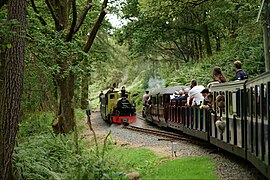 Trains passing at the loop, just to the west of the halt
 -
 River Mite at the water tank, just to the east of the halt
.jpg)

References
- ^ "The Railway". The Ravenglass & Eskdale Railway Preservation Society. Archived from the original on 30 June 2016. Retrieved 30 June 2016.
| Preceding station | Following station | |||
|---|---|---|---|---|
| The Green | Ravenglass and Eskdale Railway | Beckfoot | ||
This article on a railway station in North West England is a stub. You can help Wikipedia by expanding it. |