Kilingi-Nõmme
Kilingi-Nõmme | |
|---|---|
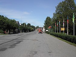
 The main street in Kilingi-Nõmme | |
| Coordinates: 58°08′59″N 24°57′41″E / 58.14972°N 24.96139°E | |
| Country | Estonia |
| County | Pärnu County |
| Municipality | Saarde Parish |
| First mentioned | 1560 |
| Borough rights | 1919 |
| Town rights | 1 May 1938 |
| Area | |
• Total | 4.26 km2 (1.64 sq mi) |
| Population (2018)[1] | |
• Total | 1,671 |
| • Rank | 37th |
| • Density | 390/km2 (1,000/sq mi) |
| Time zone | UTC+2 (EET) |
| • Summer (DST) | UTC+3 (EEST) |
| Postal code | 86301 to 86305 |
| Area code | (+372) 44 |
| Vehicle registration | F |
Kilingi-Nõmme is a town in Pärnu County, southwestern Estonia. It is the administrative centre of Saarde Parish. It's located on the intersection of Valga–Uulu (Valga–Pärnu, nr 6) and Tartu–Viljandi–Kilingi-Nõmme (nr 92) roads, about 11 km (7 mi) from the Estonian border with Latvia.
History
The settlement was first mentioned in 1560 when a manor named Ovelgunne (also Kurkund) belonging to the Schilling family was established. In 1789 a tavern was opened in the nearby Nõmme farmstead. Hence the name "Kilingi-Nõmme", Kilingi derived from the Schilling surname. In the 1870s when most of the manor's land was handed out to Orthodox believers, the settlement started to develop faster. Local congregation was established in 1845, and a parish school three years later. Kilingi-Nõmme was then the centre of the surrounding Saarde Parish.[2][3]
After the establishment of sawmill, flour mill and spinning factory, Kilingi-Nõmme gained the borough rights in 1919 and eventually the town rights on 1 May 1938.[2]
In 1896, a Pärnu–Mõisaküla–Rūjiena–Valga narrow gauge railway (750 mm (2 ft 5+1⁄2 in)) was built, the station in Kilingi-Nõmme was opened in 1917, before that the nearest station was Woltveti 1.7 km (1.1 mi) southeast in Tihemetsa. In 1975 the narrow gauge railway was closed and a new 1,520 mm (4 ft 11+27⁄32 in) Russian gauge railway (1,524 mm (5 ft)) was opened in 1981 as part of the Tallinn–Pärnu–Riga railway. Eventually this was also closed in 2000 and dismantled in 2008.
After the reindependence of Estonia in 1991, Kilingi-Nõmme served as a sovereign municipality, but merged with neighbouring Saarde and Tali parishes in 2005, and became the centre of the new Saarde Parish.[2]
-
The now defunct Kilingi-Nõmme railway station.
-
Memorial to the men of Saarde Parish who fought in the Estonian War of Independence.
Population
As of 2011 Census, the town's population was 1,763.[4]
| Year | 1900 | 1928 | 1934 | 1959 | 1970 | 1979 | 1989 | 2000 | 2003 | 2006 | 2008 | 2010 |
|---|---|---|---|---|---|---|---|---|---|---|---|---|
| Population | ca 500 | 1422 | 1663 | 2141 | 2319 | 2507 | 2504 | 2223 | 2207 | 2144 | 2106 | 2082 |
Notable people
- Reio Avaste (born 1976), architect
- Liisi Koikson (born 1983), singer
- Ants Laaneots (born 1948), military commander
- Lauri Laasi (born 1974), politician
- Paul Lilleleht (1893–1955), military commander
- Marie Reisik (1887–1941), politician and women's rights activist
- Mart Siimann (born 1946), politician
- Helene Vannari (born 1948), actress
- Toomas Voll (born 1958), composer and choral conductor
References
- ^ Population by sex, age and place of residence after the 2017 administrative reform, 1 January. Statistics Estonia.
- ^ a b c d "Kilingi-Nõmme" (in Estonian). Eesti Entsüklopeedia. Retrieved 2 September 2013.
- ^ "Kiling-Nõmme" (in Estonian). eestigiid.ee. Retrieved 2 September 2013.
- ^ "Population by place of residence (settlement), sex and age". Statistics Estonia. 31 December 2011. Retrieved 2 September 2013.
External links
![]() Media related to Kilingi-Nõmme at Wikimedia Commons
Media related to Kilingi-Nõmme at Wikimedia Commons


