Hannō
Hannō
飯能市 | |
|---|---|
 View of Hannnō from Mount Tenran | |
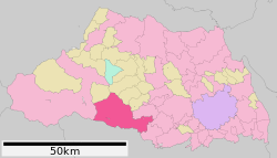
 Location of Hannō in Saitama Prefecture | |
| Coordinates: 35°51′20.4″N 139°19′39.8″E / 35.855667°N 139.327722°E | |
| Country | Japan |
| Region | Kantō |
| Prefecture | Saitama Prefecture |
| Government | |
| • Mayor | Masaru Okubo (since August 2013) |
| Area | |
| • Total | 193.05 km2 (74.54 sq mi) |
| Population (February 2016) | |
| • Total | 80,658 |
| • Density | 418/km2 (1,080/sq mi) |
| Time zone | UTC+9 (Japan Standard Time) |
| - Tree | Cryptomeria japonica |
| - Flower | Rhododendron |
| - Bird | Cettia diphone |
| Address | 1-1 Namiyanagi, Hannō-shi, Saitama-ken 357-8501 |
| Website | https://www.city.hanno.lg.jp/ |

Hannō (飯能市, Hannō-shi) is a city located in Saitama Prefecture, Japan. As of 1 February 2016[update], the city had an estimated population of 80,658, and a population density of 418 persons per km². Its total area is 193.05 square kilometres (74.54 sq mi).
Geography
Hannō is located on the southern border of Saitama Prefecture, bordered by the Tokyo to the south and the Chichibu region to the west. Both the Iruma River and the Koma River flow through the city. Hannō is mainly made up of urban and suburban areas, surrounded by mountains and rivers.
Surrounding municipalities
History
Hannō was traditionally noted for its lumber industry, which developed during the Edo period to supply Edo with timber needed for rebuilding after its frequent fires.
The modern town of Hannō was established within Koma District, Saitama with the establishment of the municipalities system on April 1, 1889. Koma District was abolished in 1896, becoming part of Iruma District.
Hannō annexed the neighboring villages of Seimei, Minami-Koma, Kaji and Moto-Kaji on April 1, 1943. It was elevated to city status on January 1, 1954. Hannō annexed the neighboring villages of Agano, Gigshi-Agano, Haraichiba on September 30, 1956 On January 1, 2005, the village of Naguri was merged into Hannō.
Economy
The economy of Hannō is mixed, with a number of pharmaceutical firms and electronics firms maintaining factories in the area. A substantial fraction of the population commutes to Tokyo every day.
Education
- Surugadai University – Hannō campus
- Hannō has 14 elementary schools, eight public and two private middle schools and five high schools.
Transportation
Railway
- JR East - Hachiko Line
- Seibu Railway - Seibu Ikebukuro Line/Seibu Chichibu Line
- Hannō - Higashi-Hannō - < Koma - Musashi-Yokote > - Higashi-Agano - Agano - Nishi-Agano - Shōmaru
Highway
Sister cities
 - Brea, California USA since January 5, 1981.
Local attractions
- JLPGA Mitsubishi Ladies Golf, late October
- Hannō Festival, first weekend of November
- Moomin Valley Park[1] The theme park opened 2019.
- Akebono Children's Forest Park is another Moomin themed public park for children that opened in 1997.
In popular culture
The anime series Encouragement of Climb is set in Hannō.
Noted people from Hannō
- Yasue Sato, model, actress
- Makoto Matsubara, professional baseball player
- Mimura (actress)
References
External links
- Official Website (in Japanese)


