Nordelph
| Nordelph | |
|---|---|
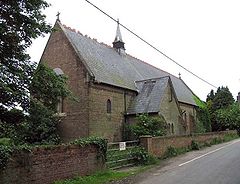
 Holy Trinity, Nordelph | |
Location within Norfolk | |
| Area | 16.57 km2 (6.40 sq mi) |
| Population | 405 |
| • Density | 24/km2 (62/sq mi) |
| OS grid reference | TF556008 |
| Civil parish |
|
| District | |
| Shire county | |
| Region | |
| Country | England |
| Sovereign state | United Kingdom |
| Post town | DOWNHAM MARKET |
| Postcode district | PE38 |
| Police | Norfolk |
| Fire | Norfolk |
| Ambulance | East of England |
Nordelph is a civil parish near Downham Market in the English county of Norfolk.
The parish covers an area of 16.57 km2 (6.40 sq mi) and had a population of 375 in 151 households at the 2001 census,[1] increasing to 405 at the 2011 Census.[2] In 1930 a new civil parish of Nordelph was created in Downham Rural District, taking land mostly out of the Marshland RD parishes of Upwell and Outwell.[3]
For the purposes of local government, Nordelph falls within the district of King's Lynn and West Norfolk.
The Church of England parish church, Holy Trinity, is of brick in the Early English style, and was erected in 1865 as a chapel of ease to the parish church of Upwell.[4] A new ecclesiastical parish was formed in 1909 from the parishes of Upwell, Downham West, Denver, Stow Bardolph and Outwell. The Reverend Edwin Emmanuel Bradford (1860–1944), Uranian poet and novelist, was vicar of Nordelph from 1909 to 1944.[5] In 1912, there were also Wesleyan Methodist and United Methodist chapels.[6]
References
- ^ Census population and household counts for unparished urban areas and all parishes Archived 11 February 2017 at the Wayback Machine. Office for National Statistics & Norfolk County Council (2001). Retrieved 20 June 2009.
- ^ "Civil Parish population 2011". Retrieved 28 August 2015.
- ^ "Upwell CP through time: Population Statistics: Area (acres)". A Vision of Britain through Time. GB Historical GIS / University of Portsmouth. Shows reduction in Upwell between 1921 & 1931. Note that several other pages on the site fail to report this transfer. Retrieved 26 June 2017.
- ^ F.J.Gardiner (1898). History of Wisbech and Neighbourhood. Gardiner & Co. p. 397.
- ^ "Holy Trinity, Nordelph". Norfolk Churches. Retrieved 29 July 2007.
- ^ Kelly's Directory of Norfolk (1912)
External links
![]() Media related to Nordelph at Wikimedia Commons
Media related to Nordelph at Wikimedia Commons

