Alcobaça, Bahia
Appearance
From Wikipedia, the free encyclopedia
This is an old revision of this page, as edited by Swidran (talk | contribs) at 23:08, 31 March 2020 (+flag, +seal). The present address (URL) is a permanent link to this revision, which may differ significantly from the current revision.
Municipality in Bahia, Brazil
Alcobaça | |
|---|---|
Municipality | |
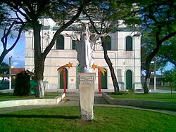
 Church in Alcobaça | |
 Location in Bahia | |
| Coordinates: 17°31′08″S 39°11′46″W / 17.519°S 39.196°W / -17.519; -39.196 | |
| Country | Brazil |
| State | Bahia |
Alcobaça is a municipality of Bahia, Brazil.
The municipality contains part of the Cassurubá Extractive Reserve, a 100,768 hectares (249,000 acres) sustainable use conservation unit that protects an area of mangroves, river and sea where shellfish are harvested.[1] The Timbebas reef opposite Alcobaça is part of the 91,330 hectares (225,700 acres) Abrolhos Marine National Park, a conservation unit created in 1983.[2]
References
- ^ RESEX do Cassurubá (in Portuguese), ISA: Instituto Ambiental, retrieved 2016-06-22
- ^ Parque Nacional Marinho dos Abrolhos (in Portuguese), ICMBio, retrieved 2016-04-30


