
Bilar, Bohol
Bilar | |
|---|---|
| Municipality of Bilar | |
 Bilar, Bohol | |
 Map of Bohol with Bilar highlighted | |
OpenStreetMap  | |
.svg) Bilar Location within the Philippines | |
| Coordinates: 9°42′N 124°06′E / 9.7°N 124.1°E | |
| Country | |
| Region | Central Visayas |
| Province | Bohol |
| District | 3rd District |
| Barangays | 19 (see Barangays) |
| Government | |
| • Type | Sangguniang Bayan |
| • Mayor | Manuel G. Jayectin |
| • Vice Mayor | Norman D. Palacio |
| • Congressman | Kristine Alexie B. Tutor |
| • Electorate | 13,418 voters (2022) |
| Area | |
| • Total | 129.71 km2 (50.08 sq mi) |
| Elevation | 315 m (1,033 ft) |
| Population (2020 census)[3] | |
| • Total | 18,512 |
| • Density | 140/km2 (370/sq mi) |
| • Households | 4,172 |
| Economy | |
| • Income class | 4th municipal income class |
| • Poverty incidence | 23.81% (2015)[4] |
| • Revenue (₱) | ₱ 104.1 million (2020) |
| • Assets (₱) | ₱ 246.1 million (2020) |
| • Liabilities (₱) | ₱ 56.41 million (2020) |
| • Expenditure (₱) | ₱ 114.1 million (2020) |
| Time zone | UTC+8 (PST) |
| ZIP code | 6317 |
| PSGC | |
| IDD : area code | +63 (0)38 |
| Native languages | Boholano dialect Cebuano Tagalog |
Bilar, officially the Municipality of Bilar (Cebuano: Lungsod sa Bilar; Tagalog: Bayan ng Bilar), is a 4th class municipality in the province of Bohol, Philippines. According to the 2020 census, it has a population of 18,512 people.[3]
The town of Bilar, Bohol celebrates its fiesta on May 15, to honor the town patron Saint Isidore the Farmer.[5]
Barangays
Bilar comprises 19 barangays:
| PSGC | Barangay | Population | ±% p.a. | |||
|---|---|---|---|---|---|---|
| 2020[3] | 2010[6] | |||||
| 071208001 | Bonifacio | 1.4% | 260 | 262 | −0.08% | |
| 071208002 | Bugang Norte | 3.4% | 632 | 650 | −0.28% | |
| 071208003 | Bugang Sur | 5.0% | 918 | 940 | −0.24% | |
| 071208004 | Cabacnitan (Magsaysay) | 4.2% | 775 | 745 | 0.40% | |
| 071208005 | Cambigsi | 3.3% | 618 | 689 | −1.08% | |
| 071208006 | Campagao | 7.2% | 1,339 | 1,284 | 0.42% | |
| 071208007 | Cansumbol | 6.4% | 1,189 | 1,235 | −0.38% | |
| 071208008 | Dagohoy | 4.1% | 764 | 836 | −0.90% | |
| 071208009 | Owac | 5.3% | 973 | 975 | −0.02% | |
| 071208010 | Poblacion | 8.6% | 1,588 | 1,500 | 0.57% | |
| 071208011 | Quezon | 3.3% | 618 | 668 | −0.77% | |
| 071208012 | Riverside | 5.5% | 1,012 | 886 | 1.34% | |
| 071208013 | Rizal | 2.3% | 425 | 456 | −0.70% | |
| 071208014 | Roxas | 6.3% | 1,159 | 1,011 | 1.38% | |
| 071208015 | Subayon | 7.0% | 1,303 | 1,200 | 0.83% | |
| 071208016 | Villa Aurora | 4.0% | 737 | 731 | 0.08% | |
| 071208017 | Villa Suerte | 1.3% | 232 | 269 | −1.47% | |
| 071208018 | Yanaya | 7.0% | 1,288 | 1,123 | 1.38% | |
| 071208019 | Zamora | 9.5% | 1,760 | 1,638 | 0.72% | |
| Total | 18,512 | 17,098 | 0.80% | |||
Climate
| Climate data for Bilar, Bohol | |||||||||||||
|---|---|---|---|---|---|---|---|---|---|---|---|---|---|
| Month | Jan | Feb | Mar | Apr | May | Jun | Jul | Aug | Sep | Oct | Nov | Dec | Year |
| Mean daily maximum °C (°F) | 27 (81) |
27 (81) |
28 (82) |
30 (86) |
29 (84) |
28 (82) |
28 (82) |
28 (82) |
28 (82) |
27 (81) |
27 (81) |
27 (81) |
28 (82) |
| Mean daily minimum °C (°F) | 21 (70) |
21 (70) |
21 (70) |
22 (72) |
23 (73) |
23 (73) |
23 (73) |
23 (73) |
23 (73) |
22 (72) |
22 (72) |
21 (70) |
22 (72) |
| Average precipitation mm (inches) | 102 (4.0) |
85 (3.3) |
91 (3.6) |
75 (3.0) |
110 (4.3) |
141 (5.6) |
121 (4.8) |
107 (4.2) |
111 (4.4) |
144 (5.7) |
169 (6.7) |
139 (5.5) |
1,395 (55.1) |
| Average rainy days | 18.6 | 14.8 | 16.5 | 16.7 | 23.9 | 26.4 | 25.6 | 24.1 | 24.4 | 26.3 | 23.7 | 20.5 | 261.5 |
| Source: Meteoblue [7] | |||||||||||||
Demographics
|
| ||||||||||||||||||||||||||||||||||||||||||||||||
| Source: Philippine Statistics Authority[8][6][9][10] | |||||||||||||||||||||||||||||||||||||||||||||||||
Tourist attractions
- Bilar Man-made Mahogany Forest
- Bilar Rice Terraces
- Bohol Biodiversity Center
- Habitat Butterflies Conservation Center
- San Isidro Labrador Parish Church
- Bilar Hill Park
- Logarita Falls
- Tinugdan Spring
- Pangas Falls
Gallery
-
 Bilar Municipal Building
 -
 Road through the Rajah Sikatuna Protected Landscape (Man-made forest) in Bilar
 -
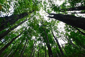 Bilar man-made forest
 -
 Public market
 -


References
- ^ Municipality of Bilar | (DILG)
- ^ "Province: Bohol". PSGC Interactive. Quezon City, Philippines: Philippine Statistics Authority. Retrieved 12 November 2016.
- ^ a b c Census of Population (2020). "Region VII (Central Visayas)". Total Population by Province, City, Municipality and Barangay. Philippine Statistics Authority. Retrieved 8 July 2021.
- ^ "PSA releases the 2015 Municipal and City Level Poverty Estimates". Quezon City, Philippines. Retrieved 12 October 2019.
- ^ "Bohol Festivals Timetable". "www.bohol-philippines.com". Retrieved 2019-03-11.
- ^ a b Census of Population and Housing (2010). "Region VII (Central Visayas)" (PDF). Total Population by Province, City, Municipality and Barangay. National Statistics Office. Retrieved 29 June 2016.
- ^ "Bilar: Average Temperatures and Rainfall". Meteoblue. Retrieved 9 May 2020.
- ^ Census of Population (2015). "Region VII (Central Visayas)". Total Population by Province, City, Municipality and Barangay. Philippine Statistics Authority. Retrieved 20 June 2016.
- ^ Censuses of Population (1903–2007). "Region VII (Central Visayas)". Table 1. Population Enumerated in Various Censuses by Province/Highly Urbanized City: 1903 to 2007. National Statistics Office.
- ^ "Province of Bohol". Municipality Population Data. Local Water Utilities Administration Research Division. Retrieved 17 December 2016.
External links
Wikimedia Commons has media related to Bilar, Bohol.
- Bilar Profile at PhilAtlas.com
- Philippine Standard Geographic Code
- Bilar
- Historical Landmarks, Places of Interest, and Things to Do in the Philippines
- Municipality of Bilar
- Nature Spots of the Philippines