Charlton Riverside
| Charlton Riverside (New Charlton) | |
|---|---|
 Aerial view of Charlton Riverside, seen from the north looking south, 2018 | |
Location within Greater London | |
| London borough | |
| Ceremonial county | Greater London |
| Region | |
| Country | England |
| Sovereign state | United Kingdom |
| Post town | LONDON |
| Postcode district | SE7 |
| Dialling code | 020 |
| Police | Metropolitan |
| Fire | London |
| Ambulance | London |
| London Assembly | |
Charlton Riverside, previously known as New Charlton, is the area along the south bank of the river Thames at Charlton, London, which forms part of the Royal Borough of Greenwich. It was formerly a primarily industrial zone, known for the glass and rope making industries, but is now an area of regeneration.[1]
Geography
The area formerly known as New Charlton is situated in the Greenwich wards of Peninsula and Woolwich Riverside. It is bounded by the river Thames in the north and the A206 (Woolwich Road) in the south. On the west it borders the Greenwich Peninsula at Horn Lane and Horn Link Way. On the east it borders Woolwich at the Thames Barrier and Eastmoor Street.
The Westminster Estate, the area between the Thames Barrier and Warspite Road, has at times been referred to as part of New Charlton. The Survey of London however regards it as a part of Woolwich, since it is situated in the historic parish of Woolwich. From 1863 until 1968 this was the site of Siemens Brothers, where many who were living across the road in New Charlton worked. This is also where Charlton Athletic F.C. played their first football matches at Siemens Meadow from 1905 until 1907.[2] In the Charlton Riverside Masterplan SPD the Westminster Estate is considered a part of Charlton Riverside. The SPD also includes Charlton railway station and a small section of Charlton Church Lane.[1]
History

Industrial development on the flat land adjoining the Thames at Charlton Riverside began in the middle of the 19th century, especially after the opening of a private railway branch line to Angerstein Wharf in 1852. A notable establishment was the Siemens Brothers Telegraph Works opened in 1863 (although the factory was largely in Woolwich). The company manufactured two new transatlantic cables in the 1880s,[3] and contributed to the PLUTO project in World War II. Since the 1960s the area had sunk into industrial decline, with most of the original factories closing (Siemens Brothers in 1968).[2]
Recent history; regeneration
There have been several regeneration projects in the area, starting in the 1980s, after the opening of the Thames Barrier. It was identified as part of an Opportunity Area by the Mayor of London in 2008 and, more clearly, in the London Plan of 2011. Regeneration of the area is now focused on the Charlton Riverside Masterplan agreed by the Royal Borough of Greenwich in April 2012 and updated in February 2017. The masterplan envisages a series of new neighbourhoods with medium-rise housing and a significant proportion of family homes. A network of streets and open spaces will be shaped by the area's industrial heritage.[1]
In 2013, Royal Greenwich UTC opened as part of this plan. The college failed to attract sufficient numbers of students and in 2016 was converted into a free school, Royal Greenwich Trust School.[4] Adjacent to it, also on Woolwich Road and officially in Woolwich, is Windrush Primary School, formerly Maryon Park School, from the 1990s until 2015 Holborn College.
New commercial developments include the Greenwich Shopping Park,[5] the Peninsula Retail Park and Stone Lake Retail Park.[6] A new Sainsbury's superstore opened in 2015 between Woolwich Road and Bugsby's Way. Sainsbury's also has a large distribution centre in New Charlton; it was rebuilt and expanded in 2012 and re-opened by deputy prime minister Nick Clegg in 2013.[7] A new IKEA-store is expected to open in 2019.[8][9]
Description
Northern part
In total there are around 400 businesses in Charlton Riverside (including the section east of the Thames Barrier).[1] One of the few remaining industrial facilities on the riverside is the construction aggregate and ready mix cement works of Aggregate Industries at Angerstein Wharf adjacent to the Greenwich Peninsula.
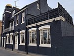
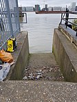
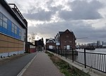
The southern end of the Thames Barrier which opened in 1983 is at Charlton Riverside. The Thames Path was laid out here shortly afterwards but officially only opened in 1996. There is only one functioning public house in the area, the Anchor & Hope, with an outdoor café overlooking the Thames. A set of watermen's stairs has survived here, reconstructed in concrete. The former Lads of the Village pub was later named the Thames Barrier Arms. It is now a veterinary clinic. A former industrial site near the Thames Barrier houses an indoor paintball facility.
Southern part
The southern part of Charlton Riverside along Woolwich Road and Bugsby's Road is now dominated by shopping centres, supermarkets and retail warehouses. Large retailers are Asda, Sainsbury's, Makro, Argos and Marks & Spencer. In the south-west corner, around Woolwich Road and Aldeburgh Street there is some housing, as well as along Anchor and Hope Lane. East of this street is Ropery Business Park with several small business.
-
Conveyors handling bulk aggregate
-
Cemex Silos at Angerstein Wharf
-
The Anchor & Hope public house
-
Reconstructed watermen's stairs
-
Thames Path near the Anchor & Hope
-
Thames Path near Thames Barrier
-
Thames Barrier park and administrative buildings
-
Former Thames Barrier Arms public house
References
- ^ a b c d "Charlton Riverside Masterplan Supplementary Planning Document. Updated: February 2017". AECOM & Royal Borough of Greenwich. Retrieved 26 April 2018.
- ^ a b Saint & Guillery, The Survey of London vol. 48: Woolwich, Yale, 2012 (online PDF, pp. 44-53).
- ^ A Visit to the Works of Messrs. Siemens Bros, The Telegraphist, 2 June 1884.
- ^ Camden, Billy (7 October 2016). "Fresh concerns over failing UTC model as one in 10 now shut". FE Week. Retrieved 4 November 2016.
- ^ Greenwich Shopping Park :: Home
- ^ Stone Lake Retail Park, Greenwich, Greater London, South East - Aberdeen Portfolio - Scheme on Completely Retail
- ^ "J Sainsbury plc / Sainsbury's opens Thameside Distribution Centre". Archived from the original on 5 July 2014. Retrieved 24 April 2018.
- ^ IKEA is coming to Greenwich on ikea.com.
- ^ Ikea coming to Greenwich – can we stop it grinding Charlton to a halt? on charltonchampion.co.uk, March 11, 2015.


