Zarow
This is an old revision of this page, as edited by Willbb234 (talk | contribs) at 17:27, 8 December 2020 (Importing Wikidata short description: "River in Germany" (Shortdesc helper)). The present address (URL) is a permanent link to this revision, which may differ significantly from the current revision.
This article does not cite any sources. Please help improve this article by adding citations to reliable sources. Unsourced material may be challenged and removed. Find sources: "Zarow" – news · newspapers · books · scholar · JSTOR (September 2020) (Learn how and when to remove this message) |
| Zarow | |
|---|---|
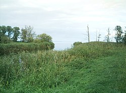
 Mouth of the Zarow | |
| Location | |
| Country | Germany |
| State | Mecklenburg-Vorpommern |
| Physical characteristics | |
| Source | Mecklenburg-Vorpommern |
| • location | Ferdinandshof |
| Mouth | Oder Lagoon |
• location | Grambin |
• coordinates | 53°45′28″N 14°01′54″E / 53.7577°N 14.0318°E / 53.7577; 14.0318 |
| Length | 16 km (9.9 mi) |
The Zarow is a river in Western Pomerania, Mecklenburg-Vorpommern, Germany. The ditches of the Friedländer Große Wiese dispatch to two main ditches, merging at Ferdinandshof, from where the river is called Zarow. The Zarow flows through the Ueckermünder Heide ("Ueckermünde heath") and after 16 kilometers reaches the Oder Lagoon near Grambin, some kilometers west of the mouth of the Uecker. The Zarow area became meliorated and settled in 1730, when it became part of Prussian Pomerania.
Geography of Pomerania | |||||
|---|---|---|---|---|---|
| Regions |
| ||||
| Administration | |||||
| Cities and towns |
| ||||
| Inhabited islands | |||||
| Peninsulae and headlands | |||||
| Rivers | |||||
| Lakes | |||||
| Bays, lagoons | |||||
| National parks | |||||
This Vorpommern-Greifswald location article is a stub. You can help Wikipedia by expanding it. |
This article related to a river in Mecklenburg-Western Pomerania is a stub. You can help Wikipedia by expanding it. |
