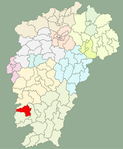
Shangyou County
This article needs additional citations for verification. (November 2018) |
Shangyou County
上犹县 Shangyiu; Shangyu | |
|---|---|
 Shangyou in Jiangxi | |
| Coordinates: 25°47′06″N 114°33′04″E / 25.785°N 114.551°E | |
| Country | People's Republic of China |
| Province | Jiangxi |
| Prefecture-level city | Ganzhou |
| Postal Code | 34???? |
Shangyou County (simplified Chinese: 上犹县; traditional Chinese: 上猶縣; pinyin: Shàngyóu Xiàn) is a county in the southwest of Jiangxi province, bordering Hunan province to the west. It is under the jurisdiction of the prefecture-level city of Ganzhou.
Administration
The county executive, legislature, judiciary are at Dongshan Town (东山镇), together with the CPC and PSB branches.
Shangyou County is divided to 5 towns and 9 townships.[1]
- 5 Towns
|
|
- 9 Townships
|
|
Climate
| Climate data for Shangyou (1981−2010) | |||||||||||||
|---|---|---|---|---|---|---|---|---|---|---|---|---|---|
| Month | Jan | Feb | Mar | Apr | May | Jun | Jul | Aug | Sep | Oct | Nov | Dec | Year |
| Record high °C (°F) | 26.6 (79.9) |
30.8 (87.4) |
32.2 (90.0) |
35.0 (95.0) |
36.5 (97.7) |
37.8 (100.0) |
40.0 (104.0) |
40.0 (104.0) |
38.6 (101.5) |
36.5 (97.7) |
33.3 (91.9) |
28.1 (82.6) |
40.0 (104.0) |
| Mean daily maximum °C (°F) | 12.8 (55.0) |
14.6 (58.3) |
17.9 (64.2) |
24.2 (75.6) |
28.5 (83.3) |
31.4 (88.5) |
34.3 (93.7) |
33.7 (92.7) |
30.5 (86.9) |
26.3 (79.3) |
21.0 (69.8) |
15.6 (60.1) |
24.2 (75.6) |
| Daily mean °C (°F) | 8.0 (46.4) |
10.0 (50.0) |
13.4 (56.1) |
19.2 (66.6) |
23.4 (74.1) |
26.4 (79.5) |
28.6 (83.5) |
28.0 (82.4) |
25.3 (77.5) |
20.8 (69.4) |
15.1 (59.2) |
9.6 (49.3) |
19.0 (66.2) |
| Mean daily minimum °C (°F) | 4.9 (40.8) |
7.0 (44.6) |
10.4 (50.7) |
15.8 (60.4) |
19.8 (67.6) |
22.9 (73.2) |
24.2 (75.6) |
24.1 (75.4) |
21.6 (70.9) |
16.8 (62.2) |
11.1 (52.0) |
5.6 (42.1) |
15.4 (59.6) |
| Record low °C (°F) | −4.0 (24.8) |
−3.4 (25.9) |
−2.2 (28.0) |
3.4 (38.1) |
10.8 (51.4) |
14.5 (58.1) |
19.0 (66.2) |
20.2 (68.4) |
13.7 (56.7) |
4.5 (40.1) |
−0.5 (31.1) |
−5.7 (21.7) |
−5.7 (21.7) |
| Average precipitation mm (inches) | 64.5 (2.54) |
108.1 (4.26) |
164.4 (6.47) |
170.3 (6.70) |
217.4 (8.56) |
210.1 (8.27) |
142.6 (5.61) |
158.4 (6.24) |
114.4 (4.50) |
55.8 (2.20) |
52.6 (2.07) |
35.4 (1.39) |
1,494 (58.81) |
| Average relative humidity (%) | 78 | 80 | 83 | 82 | 81 | 81 | 76 | 78 | 78 | 75 | 75 | 75 | 79 |
| Source: China Meteorological Data Service Center[2] | |||||||||||||
References
- ^ "南京市-行政区划网 www.xzqh.org" (in Chinese). XZQH. Retrieved 2012-05-24.
- ^ 中国地面气候标准值月值(1981-2010) (in Simplified Chinese). China Meteorological Data Service Center. Retrieved 20 October 2018.
