Wendell State Forest
From Wikipedia, the free encyclopedia
This is an old revision of this page, as edited by Monkbot (talk | contribs) at 00:59, 25 December 2020 (Task 18 (cosmetic): eval 1 template: hyphenate params (1×);). The present address (URL) is a permanent link to this revision, which may differ significantly from the current revision.
Revision as of 00:59, 25 December 2020 by Monkbot (talk | contribs) (Task 18 (cosmetic): eval 1 template: hyphenate params (1×);)
| Wendell State Forest | |
|---|---|
 Beaver activity on Ruggles Pond | |
| Location | Wendell, Franklin, Massachusetts, United States |
| Coordinates | 42°33′0″N 72°27′11″W / 42.55000°N 72.45306°W / 42.55000; -72.45306 |
| Area | 7,566 acres (30.62 km2) |
| Established | Unspecified |
| Operator | Massachusetts Department of Conservation and Recreation |
| Website | Wendell State Forest |
Wendell State Forest is a Massachusetts state forest located in the town of Wendell. The 7,566-acre (3,062 ha) parcel occupies a forested and hilly upland plateau south of the Millers River and west of the Quabbin Reservoir. Park roads were developed by the Civilian Conservation Corps in the 1930s.[1]
Activities and amenities
- Ponds: The day-use area at 10-acre (4.0 ha) Ruggles Pond offers swimming, fishing and a picnic area. The southern end of Ruggles Pond has beaver activities, while the northern end has human activities. Wickett Pond has a boat ramp at its northern end.
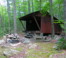
- Trails: Trails are used for walking, hiking, mountain biking, horseback riding, and cross-country skiing. Backcountry camping is available at a lean-to along the Metacomet-Monadnock Trail.
- The forest is also used for hunting (in season) and forest product extraction.

References
- ^ "Wendell State Forest". MassParks. Executive Office of Energy and Environmental Affairs. Retrieved August 12, 2013.
External links
- Wendell State Forest Department of Conservation and Recreation

