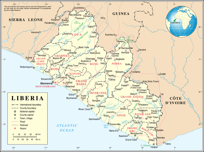
Administrative divisions of Liberia
Appearance
It has been suggested that Clans of Liberia be merged into this article. (Discuss) Proposed since October 2015. |

Liberia is divided into fifteen counties, which, in turn, are subdivided into a total of 90 districts and further subdivided into clans.
Governance
The fifteen counties are administered by superintendents appointed by the president. The Constitution calls for the election of various chiefs at the county and local level. These elections have not taken place since 1985 due to war and financial constraints.[1]
Counties
There are 15 counties in Liberia.
| # | County | Capital | Established | Area (km2) | Population (2008 Census) |
|---|---|---|---|---|---|
| 1 | Tubmanburg | 1984 | 1,932 | 84,119 | |
| 2 | Gbarnga | 1964 | 8,754 | 333,481 | |
| 3 | Bopulu | 2001 | 9,953 | 83,388 | |
| 4 | Buchanan | 1847 | 7,814 | 221,693 | |
| 5 | Robertsport | 1856 | 4,781 | 127,076 | |
| 6 | Zwedru | 1964 | 10,855 | 125,258 | |
| 7 | Barclayville | 1984 | 3,895 | 57,913 | |
| 8 | Voinjama | 1964 | 9,982 | 276,863 | |
| 9 | Kakata | 1985 | 2,691 | 209,923 | |
| 10 | Harper | 1857 | 2,297 | 135,938 | |
| 11 | Bensonville | 1847 | 1,880 | 1,118,241 | |
| 12 | Sanniquellie | 1964 | 11,551 | 462,026 | |
| 13 | Rivercess | 1985 | 5,564 | 71,509 | |
| 14 | Fish Town | 2000 | 5,113 | 66,789 | |
| 15 | Greenville | 1847 | 9,764 | 102,391 |
Districts
|
Clans
See also
References
- ^ "Liberia cannot afford local polls". BBC News. January 14, 2008.
