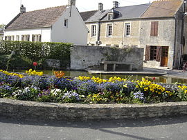
Basly
Basly | |
|---|---|
 The old Lavoir at Basly | |
| Country | France |
| Region | Normandy |
| Department | Calvados |
| Arrondissement | Caen |
| Canton | Creully |
| Intercommunality | Cœur de Nacre |
| Government | |
| • Mayor (2008–2020) | Yves Gauquelain |
| Area 1 | 3.92 km2 (1.51 sq mi) |
| Population (2010) | 1,093 |
| • Density | 280/km2 (720/sq mi) |
| Time zone | UTC+01:00 (CET) |
| • Summer (DST) | UTC+02:00 (CEST) |
| INSEE/Postal code | 14044 /14610 |
| Elevation | 18–62 m (59–203 ft) (avg. 70 m or 230 ft) |
| 1 French Land Register data, which excludes lakes, ponds, glaciers > 1 km2 (0.386 sq mi or 247 acres) and river estuaries. | |
Basly is a French commune in the Calvados department in the Basse-Normandie region of north-western France.[1]
The inhabitants of the commune are known as Basliens or Basliennes.[2]
Geography
Basly is located some 6 km south-east of Courseulles-sur-Mer and 10 km north-west of Caen. Access to the commune is by the D79 road from Bény-sur-Mer in the north-east which passes through the village and continues south-east to Colomby-sur-Thaon. The D83 comes from Douvres-la-Délivrande in the north-east through the village then south-west to Thaon. The D404 passes through the north-east corner of the commune and the D141 from Fontaine-Henry to Colomby-sur-Thaon passes through the south-west corner. The commune is entirely farmland.[3][4]
The Mue river forms the border of the south-western corner of the commune as it twists around then flows north-west to join the Seulles at Reviers.[3][4]
Mapping
A list of online mapping systems can be displayed by clicking on the coordinates (latitude and longitude) in the top right hand corner of this article.
Neighbouring communes and villages
History
At a place called Campagne in the commune (near the Moto-Club) many archaeological remains have been found. This is on a spur blocked by the valley of the Mue. The most famous remains are those of a habitat from the first Iron Age (the Hallstatt culture) with an associated rectangular necropolis. There is archaeological evidence of a Neolithic stockade in medieval times.
Basly appears as Basly on the 1750 Cassini Map[5] and the same on the 1790 version.[6]
Administration

| From | To | Name | Party | Position |
|---|---|---|---|---|
| 1800 | 1844 | Louis | ||
| 1860 | 1879 | Paisant | ||
| 1879 | 1891 | Viel | ||
| 1894 | 1896 | Maillard | ||
| 1894 | 1896 | Viel | ||
| 1896 | 1903 | Legras | ||
| 1903 | 1904 | Marie | ||
| 1942 | 1953 | Leboucher | ||
| 1953 | 1959 | Marie | ||
| 1959 | 1965 | Leboucher | ||
| 1965 | 1971 | Marie | ||
| 1971 | 1979 | Vauvert | ||
| 1979 | 1983 | Coutard | ||
| 1983 | 1989 | Lemarchand | ||
| 1989 | 2008 | François Oudin | ||
| 2008 | 2020[8] | Yves Gauquelain | Retired |
(Not all data is known)
The Municipal Council is composed of 15 members including the Mayor and 4 deputies.[9]
Demography
In 2010 the commune had 1093 inhabitants. The evolution of the number of inhabitants is known from the population censuses conducted in the commune since 1793. From the 21st century, a census of communes with fewer than 10,000 inhabitants is held every five years, unlike larger communes that have a sample survey every year.[Note 1]
Template:Table Population Town

Culture and heritage
Religious heritage

The Church of Saint Georges Bell Tower (12th century)![]() is registered as an historical monument.[10]
is registered as an historical monument.[10]
Festivals and events

Sports
- The Football Club of Basly has two soccer teams in district divisions.[11]
- The 'Moto Club was created in 1977 and has a motocross circuit and a driving school.[12]
Notable people linked to the commune
- Déodat de Basly (1862 at Basly - 1937), religious and Franciscan theologian.
See also
Notes and references
Notes
- ^ At the beginning of the 21st century, the methods of identification have been modified by Law No. 2002-276 of 27 February 2002, the so-called "law of local democracy" and in particular Title V "census operations" allows, after a transitional period running from 2004 to 2008, the annual publication of the legal population of the different French administrative districts. For communes with a population greater than 10,000 inhabitants, a sample survey is conducted annually and the entire territory of these communes is taken into account at the end of the period of five years. The first "legal population" after 1999 under this new law came into force in 1 January 2009 and was based on the census of 2006.
References
- ^ Basly on Lion1906
- ^ Inhabitants of Calvados Template:Fr icon
- ^ a b c Basly on Google Maps
- ^ a b Basly on the Géoportail from National Geographic Institute (IGN) website Template:Fr icon
- ^ Basly on the 1750 Cassini Map
- ^ Basly on the 1790 Cassini Map
- ^ List of Mayors of France Template:Fr icon
- ^ Reelection 2014: Basly (14610) 2014, Ouest-France, consulted on 8 June 2014 Template:Fr icon
- ^ art L. 2121-2 of the General Code of Collective Territories Template:Fr icon.
- ^ Ministry of Culture, Mérimée PA00111039 Church of Saint Georges Bell Tower Template:Fr icon
- ^ Official website of the Basse-Normandie League – FC Basly, consulted on 27 March 2014 Template:Fr icon
- ^ Moto-club of Basly website, consulted on 27 August 2010 Template:Fr icon
External links

