
Biddeford, Maine
Biddeford, Maine | |
|---|---|
 City Hall | |
 Seal | |
| Motto: "A Proud City Rising Where the Water Falls" | |
| Country | United States |
| State | Maine |
| County | York |
| First Landing | 1616 |
| Settled | 1631 |
| Incorporated (town) | November 17, 1718 |
| Incorporated (city) | February 10, 1855 |
| Government | |
| • Mayor | Joanne Twomey |
| Area | |
| • Total | 34.5 sq mi (89.5 km2) |
| • Land | 30.0 sq mi (77.7 km2) |
| • Water | 4.5 sq mi (11.7 km2) |
| Elevation | 69 ft (21 m) |
| Population (2010) | |
| • Total | 21,277 |
| • Density | 709.2/sq mi (273.8/km2) |
| Time zone | UTC-5 (EST) |
| • Summer (DST) | UTC-4 (EDT) |
| ZIP codes | 04005, 04007 |
| Area code | 207 |
| FIPS code | 23-04860 |
| GNIS feature ID | 0562119 |
| Website | http://www.Biddefordmaine.org |
Biddeford is a city in York County, Maine, United States. It is the largest city in the county, and is the sixth-largest in the state. It is the most southerly incorporated city in the state and the principal commercial center of York County. The population was 21,277 at the 2010 census. Twin city of Saco, Biddeford includes the resort community of Biddeford Pool, Fortunes Rocks and Granite Point. The city is home to the University of New England and the annual La Kermesse Franco-Americaine Festival. First visited by Europeans in 1616, it is the site of one of the earliest European settlements in the United States.
Biddeford is a principal city of the Portland-South Portland-Biddeford metropolitan statistical area.
History


Abenaki Indians, whose main village was upriver at Pequawket (now Fryeburg), once hunted and fished in the area. The first European to settle at Biddeford was physician Richard Vines in the winter of 1616-1617 at Winter Harbor, as he called Biddeford Pool. This 1616 landing by a European predates the Mayflower landing in Plymouth, Massachusetts, (located 100 miles to the south) by approximately four years, a fact that is overlooked in much of New England lore.[1] In 1630, the Plymouth Company granted the land south of the River Swanckadocke to Dr. Vines and John Oldham. In 1653, the town included both sides of the river, and was incorporated by the Massachusetts General Court as Saco.[2]
Roger Spencer was granted the right in 1653 to build the first sawmill. Lumber and fish became the community's chief exports. In 1659, Major William Phillips of Boston became a proprietor, and constructed a garrison and mill at the falls. During King Philip's War in 1675, the town was attacked by Indians. Settlers withdrew to Winter Harbor for safety, and their homes and mills upriver at the falls were burned. In 1693, a stone fort was built a short distance below the falls, but it was captured by the Indians in 1703, when 11 colonists were killed and 24 taken captive to Canada. In 1708, Fort Mary was built near the entrance to Biddeford Pool. The town was reorganized in 1718 as Biddeford, after Bideford, a town in Devon, England, from which some settlers had emigrated. After the Fall of Quebec in 1759, hostilities with the natives ceased.[2]
In 1762, the land northeast of the river was set off as Pepperellborough, which in 1805 was renamed Saco. The first bridge to Saco was built in 1767. The river divides into two falls that drop 40 feet (12 m), providing water power for mills. Factories were established to make boots and shoes. The developing mill town also had granite quarries and brickyards, in addition to lumber and grain mills. Major textile manufacturing facilities were constructed along the riverbanks, including the Laconia Company in 1845, and the Pepperell Company in 1850. Biddeford was incorporated as a city in 1855.[3]
The mills attracted waves of immigrants, including the Irish, Albanians, and French-Canadians from the province of Quebec. At one time the textile mills employed as many as 12,000 people, but as happened elsewhere, the industry entered a long period of decline. As of 2010, only one textile company, WestPoint Home, remains in the city. The last log drive down the Saco River was in 1943, with the last log sawn in 1948. Biddeford's name is engraved near the top level of The Pilgrim Monument, in Provincetown, Massachusetts, along with the names of some of the oldest cities and towns in New England.[4]
-
 Main Street c. 1908
 -
 City Square c. 1910
 -
 Pepperell Mills c. 1906
 -
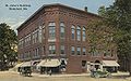 St. John's Building c. 1914


General information

Biddeford is home to large institutions including Southern Maine Medical Center and the University of New England, a fast-growing school located along the coast which includes Maine's only medical school, the University of New England College of Osteopathic Medicine.[5] The city also possesses a wide array of community facilities including public beaches, an ice arena, a full-service YMCA, and one school which has been recently recognized as a "National School of Excellence."
Biddeford High School had 224 enrolled students during the 2008-2009 school year.
Anchoring Biddeford's historic downtown are McArthur Public Library and Biddeford's City Theater. Biddeford has a number of properties and two Historic Districts entered into the National Register of Historic Places.[6] The newest addition is the Main Street Historic District, entered into the National Register on December 24, 2009. Other downtown National Register properties include the Biddeford-Saco Mills Historic District, Biddeford City Hall, Dudley Block and the U.S. Post Office. National Register properties outside of downtown and in the Biddeford Pool area include the John Tarr House, First Parish Meetinghouse, Fletcher's Neck Lifesaving Station and the James Montgomery Flagg House.[7]
Biddeford is one of Maine's fastest-growing commercial centers, due to its close proximity to the Seacoast Region of New Hampshire and to northern Massachusetts. In recent years, strip malls have developed along the State Route 111 corridor. In late 2006, a 500,000-square-foot (46,000 m2) shopping center known as The Shops at Biddeford Crossing opened, with 20 stores and five restaurants.
Recent interest in revitalizing the downtown area has brought new life to the old mills. The North Dam Mill is one example of this movement offering retail stores, art studios, cultural events, and upscale housing.
The municipality has three post offices within its borders, with ZIP codes of 04005, 04006 and 04007.
Biddeford was the eastern terminus of the now-defunct New England Interstate Route 11, which ended in Manchester, Vermont. State Route 111, which travels through Biddeford's main commercial corridor, is now numbered in Old Route 11's place. Biddeford Municipal Airport is located two miles south of the central business district.
The city has almost 15 miles (24 km) of frontage along the Saco River, and an Atlantic coastline on which the seaside neighborhoods of Hills Beach, Biddeford Pool, Fortunes Rocks and Granite Point are located. Biddeford includes Wood Island Light, a lighthouse located about a mile offshore from Biddeford Pool.
Cajetan J. B. Baumann O.F.B., AIA, (1899–1969), the first member of a religious order to be named to the American Institute of Architects earned an honorary degree from St. Francis College in Biddeford, Maine.[8]
Geography
Biddeford is located at 43°28′27″N 70°26′46″W / 43.47417°N 70.44611°W (43.474111, -70.446157)Template:GR. According to the United States Census Bureau, the city has a total area of 34.5 square miles (89.5 km²), of which 30.0 square miles (77.7 km²) is land and 4.5 square miles (11.7 km²) (13.12%) is water. Situated beside Saco Bay on the Gulf of Maine, Biddeford is drained by the Little River and the Saco River. The city proper has very diverse geography, from inland rolling hillside, to urban settlement, to coastal sprawl.
The city is crossed by Interstate 95, U. S. Route 1, and state routes 5, 9, 111 and 208. It is bordered by the city of Saco to the north, the Atlantic Ocean to the east, the towns of Dayton and Lyman to the west, and the towns of Kennebunkport and Arundel to the south. The Little River forms a portion of the border between Biddeford and the Goose Rocks neighborhood of Kennebunkport, in Biddeford's most southerly region (Granite Point). East Point, located on the peninsula of Biddeford Pool, is the easternmost point in York County.
Timber Island, the most southerly point in the City of Biddeford, lies in Goosefare Bay at the mouth of the Little River, and is accessible at low tide from Goose Rocks Beach. The island is preserved under a conservation easement; the owners allow daylight visits by the public. Currently, there is talk that the land trust that owns Timber Island and Timber Point shall sell the property to the U.S. government at a reduced price, thereby securing for conservation one of the largest parcels of undeveloped land in South Coast Maine.[9]
While Maine (as a whole) is politically and colloquially known as part of Northern New England, Biddeford's geography technically places it more in line with Central New England.
Distances from Biddeford to regional cities:

- Portland, Maine: 15 miles (24 km)
- Portsmouth, New Hampshire: 30 miles (48 km)
- Salisbury, Massachusetts: 48 miles (77 km)
- Lynn, Massachusetts: 76 miles (123 km)
- Manchester, New Hampshire: 78 miles (125 km)
- Boston, Massachusetts: 85 miles (140 km)
- Worcester, Massachusetts: 120 miles (200 km)
- Providence, Rhode Island: 147 miles (237 km)
- Bangor, Maine: 150 miles (242 km)
- Hartford, Connecticut: 187 miles (301 km)
- Stamford, Connecticut: 255 miles (410 km)
- New York City, New York: 285 miles (459 km)
- Fort Kent, Maine: 330 miles (531 km)
- Montréal, Québec: 335 miles (540 km)
- Baltimore, Maryland: 490 miles (791 km)
Demographics
| Census | Pop. | Note | %± |
|---|---|---|---|
| 1790 | 1,018 | — | |
| 1800 | 1,296 | 27.3% | |
| 1810 | 1,563 | 20.6% | |
| 1820 | 1,738 | 11.2% | |
| 1830 | 1,995 | 14.8% | |
| 1840 | 2,574 | 29.0% | |
| 1850 | 6,095 | 136.8% | |
| 1860 | 9,349 | 53.4% | |
| 1870 | 10,282 | 10.0% | |
| 1880 | 12,651 | 23.0% | |
| 1890 | 14,443 | 14.2% | |
| 1900 | 16,145 | 11.8% | |
| 1910 | 17,079 | 5.8% | |
| 1920 | 18,008 | 5.4% | |
| 1930 | 17,633 | −2.1% | |
| 1940 | 19,790 | 12.2% | |
| 1950 | 20,836 | 5.3% | |
| 1960 | 19,255 | −7.6% | |
| 1970 | 19,983 | 3.8% | |
| 1980 | 19,638 | −1.7% | |
| 1990 | 20,170 | 2.7% | |
| 2000 | 20,942 | 3.8% | |
| 2010 | 21,277 | 1.6% | |
| sources[10] | |||
As of the censusTemplate:GR of 2000, there were 20,942 people, 8,636 households, and 5,259 families residing in the city. The population density was 697.8 people per square mile (269.4/km²). There were 9,631 housing units at an average density of 320.9 per square mile (123.9/km²). The racial makeup of the city was 96.65 percent White, 0.64 percent African American, 0.40 percent Native American, 0.99 percent Asian, 0.03 percent Pacific Islander, 0.18 percent from other races, and 1.12 percent from two or more races. Hispanic or Latino of any race were 0.65 percent of the population.
There were 7,636 households out of which 28.4 percent had children under the age of 18 living with them, 44.4 percent were married couples living together, 12.2 percent had a female householder with no husband present, and 39.1 percent were non-families. 29.7 percent of all households were made up of individuals and 11.1 percent had someone living alone who was 65 years of age or older. The average household size was 2.32 and the average family size was 2.88.
In the city the population was spread out with 22.1 percent under the age of 18, 11.1 percent from 18 to 24, 29.5 percent from 25 to 44, 21.8 percent from 45 to 64, and 15.5 percent who were 65 years of age or older. The median age was 36 years. For every 100 females there were 88.2 males. For every 100 females age 18 and over, there were 84.4 males.
The median income for a household in the city was $37,164 and the median income for a family was $44,109. Males had a median income of $32,008 versus $24,715 for females. The per capita income for the city was $18,214. About 8.6 percent of families and 13.8 percent of the population were below the poverty line, including 19.8 percent of those under age 18 and 10.3 percent of those age 65 or over.
Sister cities
Biddeford has one sister city:
Sites of interest
- Biddeford Historical Society
- Franco-American Genealogical Society of York County
- City Theater for the Performing Arts
- La Kermesse Franco-Americaine Festival
- Heart of Biddeford
- Biddeford-Saco Buy Local
- Biddeford Saco Chamber of Commerce
Notable residents

- Zentatsu Richard Baker, zen instructor
- Robert Caret, Current President of the University of Massachusetts system
- Ovid Demaris, author
- Cor van den Heuvel, poet and editor
- Mark Langdon Hill, congressman
- Linda Kasabian, ex-Manson Family member involved in the Helter Skelter Murders
- Louis B. Lausier, mayor (1941–1955) and candidate for Governor (1948)
- Hilary F. Mahaney, football player
- Prentiss Mellen, senator and jurist
- Thomas Bird Mosher, publisher
- Wallace H. Nutting, general and mayor
- Freddy Parent, baseball player
- Henry B. Quinby, physician and governor
- Daniel E. Somes, congressman and mayor
- James Sullivan, jurist & governor [11]
- George Thatcher, judge & congressman [11][12]
- Joanne Twomey, state representative (1998–2006) and mayor (2006-current)
- Joan Wasser, singer/songwriter
- Amos Whitney, engineer & inventor
References
- ^ State Street Trust Company. Towns of New England and Old England. Boston, 1921.
- ^ a b Coolidge, Austin J. (1859). A History and Description of New England. Boston, Massachusetts. pp. 54–56.
{{cite book}}: Unknown parameter|coauthors=ignored (|author=suggested) (help)CS1 maint: location missing publisher (link) - ^ Varney, George J. (1886), Gazetteer of the state of Maine. Biddeford, Boston: Russell
- ^ In and About Biddeford
- ^ City of Biddeford website. http://www.biddefordmaine.org/
- ^ NPS-National Register of Historic Places. http://nrhp.focus.nps.gov/natreghome.do
- ^ NPS-National Register of Historic Places. http://nrhp.focus.nps.gov/natregsearchresult.do?briefnav=true
- ^ http://www.seacoastonline.com/apps/pbcs.dll/article?AID=/20091106/NEWS/911069954/-1/NEWSMAP
- ^ library.umaine.edu, retrieved October, 2008.
- ^ a b McArthur Public Library-Biographical Index. http://www.mcarthurpubliclibrary.org/index.php?id=20#s
- ^ McArthur Public Library-Biographical Index. http://biddeford.mainememory.net/slideshow/546/display%3Fuse_mmn=&prev_object_id=1659&prev_object=page.html
Further reading
- Biddeford History & Heritage Project - A comprehensive history website and exhibit space created by Biddeford's cultural community and hosted by the Maine Memory Network / Maine Historical Society.
- History of Saco and Biddeford by George Folsom. Saco, [Me.] : Printed by A. C. Putnam, 1830. (Courtesy of Google Books)
External links
Municipalities and communities of York County, Maine, United States | ||
|---|---|---|
| Cities |  | |
| Towns | ||
| CDPs | ||
| Unincorporated communities and villages | ||
| Footnotes | ‡This populated place also has portions in an adjacent county | |