
Chhapra
This article needs additional citations for verification. (August 2018) |
Chapra | |
|---|---|
 Chapra Location of Chapra in Bihar  Chapra Chapra (India) | |
| Coordinates: 25°47′05″N 84°43′39″E / 25.7848°N 84.7274°E | |
| State | Bihar |
| Division | Saran |
| District | Saran |
| Ward | 45 wards |
| Government | |
| • Type | Mayor–Council |
| • Body | Chhapra Municipal Corporation |
| • Mayor | Priya Devi |
| • Deputy Mayor | Amitanjali Soni |
| Area | |
| • Urban | 38.26 km2 (14.77 sq mi) |
| Elevation | 36 m (118 ft) |
| Population (2011) | |
| • City | 201,598 |
| • Urban | 249,556 |
| Demonym | Chaprahiya |
| Languages | |
| Time zone | UTC+5:30 (IST) |
| Pincode(s) | 841 301, 841 302 |
| Area code(s) | +91-6152 |
| Vehicle registration | BR 04 |
| Sex ratio | 900 (females per 1000 males)[2] ♂/♀ |
| Literacy | 78.30% |
| Lok Sabha constituencies | Saran |
| Vidhan Sabha constituencies | Chapra (118) |
| Planning agency | None |
| Avg. annual temperature | 26 °C (79 °F) |
| Avg. summer temperature | 32 °C (90 °F) |
| Avg. winter temperature | 20 °C (68 °F) |
| Website | saran chapra |
Chapra (Chapra) is a city and headquarters of the Saran district in the Indian state of Bihar. It is situated near the junction of the Ghaghara River and the Ganges River.
Chhapra grew in importance as a river-based market in the 18th century when the Dutch,[3][4] French, Portuguese, and English established saltpeter refineries in the area. It was recognized as a municipality in 1864.[citation needed] The city has major rail and road connections with the rest of India and a distance of few minutes from Uttar Pradesh by Train. There is a well known[5] shakti peeth temple in Chhapra named Ambika Bhavani.
Geography


Chhapra is located at 25°47′05″N 84°43′39″E / 25.7848°N 84.7274°E.[6] It has an average elevation of 36 metres (118 ft).
India's biggest double-decker flyover is being constructed in Chhapra.[7] This 3.5 km long double-decker flyover from Gandhi Chowk to Nagarpalika Chowk,[8] is being constructed at the cost of ₹ 411.31 crore from the central road fund (CRF) under engineering procurement construction (EPC) mode by Bihar Rajya Pul Nirman Nigam Limited (BRPNNL).[9][10] It is longer than 1.8 km double-decker flyover in Santa Cruz–Chembur Link Road.[11] Chief Minister Nitish Kumar laid the foundation stone of this double-decker flyover in July 2018, which is set to be completed by June 2022.[12]
Climate
| Climate data for Chhapra | |||||||||||||
|---|---|---|---|---|---|---|---|---|---|---|---|---|---|
| Month | Jan | Feb | Mar | Apr | May | Jun | Jul | Aug | Sep | Oct | Nov | Dec | Year |
| Mean daily maximum °C (°F) | 23.1 (73.6) |
25.8 (78.4) |
31.0 (87.8) |
35.1 (95.2) |
35.0 (95.0) |
34.9 (94.8) |
32.5 (90.5) |
32.8 (91.0) |
32.5 (90.5) |
31.6 (88.9) |
29.0 (84.2) |
24.8 (76.6) |
30.68 (87.22) |
| Mean daily minimum °C (°F) | 9.2 (48.6) |
11.0 (51.8) |
15.1 (59.2) |
19.1 (66.4) |
21.2 (70.2) |
22.9 (73.2) |
23.8 (74.8) |
24.2 (75.6) |
23.8 (74.8) |
21.2 (70.2) |
15.8 (60.4) |
10.6 (51.1) |
18.18 (64.72) |
| Average precipitation mm (inches) | 13.0 (0.51) |
14.0 (0.55) |
9.0 (0.35) |
29.0 (1.14) |
76.0 (2.99) |
139.0 (5.47) |
353.0 (13.90) |
254.0 (10.00) |
193.0 (7.60) |
73.0 (2.87) |
6.0 (0.24) |
7.0 (0.28) |
97.17 (3.83) |
| Source: Accuweather[13] | |||||||||||||
Demographics
As per 2011 census, Chapra Urban Agglomeration had a population of 212,955.[14] Chapra Urban Agglomeration includes Chapra (Nagar Panchayat) and Sandha (Census Town).[15] chapra Nagar Panchayat had a total population of 201,597, out of which 106,250 were males and 95,347 were females. It had a sex ratio of 897. The population below 5 years was 27,668. The literacy rate of Chhapra was 81.30 per cent as 2011.[16]
-
 Chapra Junction

Gallery
-
-
 Rajendra College
 -
 Loknayak Jai Prakash Institute of Technology
 -
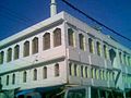 Khanua Mosque


Notable people
- Dr. Rajendra Prasad, freedom fighter and first president of India.
- Khuda Bakhsh 1842-1908, Muslim lawyer, collector of books and manuscripts and founder of Khuda Bakhsh Oriental Library, Patna
- Bhikhari Thakur, poet and singer, "Shakespeare of Bhojpuri"
- Rajiv Pratap Rudy, Minister of State (Independent Charge) Skill Development and Entrepreneurship
- Brajkishore Prasad, National Activitist
- Daroga Prasad Rai, 10th Chief Minister Of Bihar.
- Laloo Prasad Yadav, Past Member of Parliament from Saran Constituency, Past Chief Minister of Bihar, Past Railway Minister Of India.
- Surur Hoda, Socialist leader and Order of British Empire (OBE) recipient.
- Chitragupta (composer), music director and father of composers Anand-Milind
- Anand-Milind, Music Composer and the sons of Chitragupta (composer).
- Mansur Hoda, Technologist, An alumnus of Surrey University, England.
- Akhilendra Mishra, Bollywood actor.
See also
References
- ^ "CPRS Patna About Us". CRPS. Archived from the original on 5 March 2016. Retrieved 28 October 2016.
- ^ "Chapra City Census 2011 data". www.census2011.co.in.
- ^ Heritage, Atlas of Mutual. "Atlas of Mutual Heritage". www.nationaalarchief.nl.
- ^ Heritage, Atlas of Mutual. "Atlas of Mutual Heritage". www.nationaalarchief.nl.
- ^ "जानिए बिहार के तीन शक्तिपीठों में से एक सारण की अंबिका भवानी की महिमा". 29 September 2014. Archived from the original on 9 August 2016.
{{cite web}}: Unknown parameter|deadurl=ignored (|url-status=suggested) (help) - ^ "Maps, Weather, and Airports for Chapra, India". www.fallingrain.com. Archived from the original on 10 May 2008.
{{cite web}}: Unknown parameter|deadurl=ignored (|url-status=suggested) (help) - ^ "Chhapra to get Bihar's first double-decker flyover".
- ^ "Two-deck flyover cost: Rs 411cr".
- ^ "CM to open highway at Chhapra".
- ^ https://www.telegraphindia.com/1170413/jsp/bihar/story_146000.jsp
- ^ "Saran to beat Mumbai marvel".
- ^ "Flyover first on Lalu's once turf".
- ^ "Accuweather: Weather for Chhapra, India". Accuweather. 2011. Archived from the original on 3 September 2014.
{{cite web}}: Unknown parameter|deadurl=ignored (|url-status=suggested) (help) Retrieved on 22 November 2011. - ^ "Urban Agglomerations/Cities having population 1 lakh and above" (PDF). Provisional Population Totals, Census of India 2011. Archived from the original (PDF) on 13 November 2011. Retrieved 16 April 2012.
{{cite web}}: Unknown parameter|deadurl=ignored (|url-status=suggested) (help) - ^ "Constituents of urban Agglomerations Having Population 1 Lakh & above" (PDF). Provisional Population Totals, Census of India 2011. Archived from the original (PDF) on 17 June 2016. Retrieved 16 April 2012.
{{cite web}}: Unknown parameter|deadurl=ignored (|url-status=suggested) (help) - ^ "Cities having population 1 lakh and above" (PDF). Provisional Population Totals, Census of India 2011. Archived from the original (PDF) on 7 May 2012. Retrieved 16 April 2012.
{{cite web}}: Unknown parameter|deadurl=ignored (|url-status=suggested) (help)
External links
Railways in Bihar | |||||||||||
|---|---|---|---|---|---|---|---|---|---|---|---|
| Network lines Sections |
| ||||||||||
| Rail bridges | |||||||||||