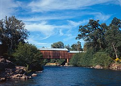
Honey Run Covered Bridge
Appearance
Honey Run Covered Bridge | |
 A picture from the Historic American Engineering Record | |
| Location | Butte County, California |
|---|---|
| Nearest city | Chico, California |
| Coordinates | 39°43′43″N 121°42′13″W / 39.72861°N 121.70361°W |
| Built | 1894 |
| Architect | Martindale, S. A. |
| Architectural style | Other |
| NRHP reference No. | 88000920 |
| Added to NRHP | June 23, 1988[1] |
Honey Run Covered Bridge is a wooden covered bridge crossing Butte Creek, in Butte County, northern California.
It is located on Honey Run Road at Centerville Road, about halfway in between Chico and Paradise.
History
The wooden Honey Run Bridge was originally built in 1886, and was later covered in 1894.
The bridge was open to vehicular traffic until a car crashed into and damaged it in 1965. An new steel bridge was built upstream for vehicular traffic.
The covered bridge is now used as a pedestrian footbridge, protected within Honey Run Covered Bridge County Park. It was rebuilt from the ruins and opened in 1972.[2]
It was listed on the National Register of Historic Places in 1988.[1]
See also
References
- ^ a b "National Register Information System". National Register of Historic Places. National Park Service. April 15, 2008.
- ^ Miller, Terry E. America's Covered Bridges. Tuttle.
External links
- Honey Run Covered Bridge
- Historic American Engineering Record (HAER) No. CA-312, "Honey Run Bridge, Spanning Butte Creek, bypassed section of Honey Run Road (originally Carr Hill Road), Paradise vicinity, Butte County, CA", 18 photos, 2 color transparencies, 9 measured drawings, 16 data pages, 2 photo caption pages
Wikimedia Commons has media related to Honey Run Covered Bridge.
Categories:
- Covered bridges in California
- Bridges in Butte County, California
- Former road bridges in the United States
- Pedestrian bridges in the United States
- Wooden bridges in California
- Covered bridges on the National Register of Historic Places in California
- Bridges completed in 1887
- History of Butte County, California
- Historic American Engineering Record in California
- Visitor attractions in Butte County, California
- National Register of Historic Places in Butte County, California
- Road bridges on the National Register of Historic Places in California
- Western United States bridge (structure) stubs
- California building and structure stubs
- California transportation stubs
- Sacramento Valley Registered Historic Place stubs
- Butte County, California geography stubs


