
Inazawa
This article needs additional citations for verification. (September 2014) |
Inazawa
稲沢市 | |
|---|---|
  Upper stage:Owari ōkunitama-jinja Lower stage:Inazawa Skyline | |
 Flag  Seal | |
 Location of Inazawa in Aichi Prefecture | |
 Inazawa | |
| Coordinates: 35°15′53″N 136°47′48.9″E / 35.26472°N 136.796917°E | |
| Country | Japan |
| Region | Chūbu (Tōkai) |
| Prefecture | Aichi Prefecture |
| Government | |
| • Mayor | Toshiaki Ōno |
| Area | |
| • Total | 79.35 km2 (30.64 sq mi) |
| Population (May 2015) | |
| • Total | 136,551 |
| • Density | 1,720/km2 (4,500/sq mi) |
| Time zone | UTC+9 (Japan Standard Time) |
| - Tree | Pine |
| - Flower | Chrysanthemum |
| Phone number | 0587-32-1111 |
| Address | 1 Inabuchō, Inazawa-shi, Aichi-ken 492-8269 |
| Website | www |

Inazawa (稲沢市, Inazawa-shi) is a city located in Aichi Prefecture, Japan.
As of May 2015, the city had an estimated population of 136,551 and a population density of 1,720 persons per km2. The total area was 79.35 square kilometres (30.64 sq mi).
Inazawa is the location of the Solae elevator testing tower, previously the highest such tower in the world, but now surpassed by the Kunshan Test Tower in China.[1][2]
Geography
Inazawa is located in the coastal flatlands of far western Aichi Prefecture, bordering Gifu Prefecture on the west.
Surrounding municipalities
- Aichi Prefecture
- Gifu Prefecture
History
Inazawa is the location of the Nara period provincial capital and provincial temple of Owari Province. The Owari Onkunitama Jinja, an important Shinto shrine located within the borders of the present city, also dates from this period. During the Edo period, Inaba and Ozawa villages formed a post town on the Minoji, a kaidō connecting Miya-juku (Atsuta on the Tōkaidō to Tarui-juku (Mino Province) on the Nakasendō. During the Meiji period, the town of Inazawa was created. The area of the town was expanded in 1907 and 1955 through the annexation of neighboring villages, and on November 1, 1958, the Inazawa was elevated to city status.
On April 1, 2005, the towns of Heiwa and Sobue (both from Nakashima District) were merged into Inazawa.
-
 Shobata Castle

Transportation
Railways
- Central Japan Railway Company – Tokaido Main Line
- Meitetsu – Nagoya Main Line
- Ōsato – Okuda – Kōnomiya – Shima-Ujinaga
- Meitetsu – Bisai Line
- Rokuwa – (Fuchidaka) – Marubuchi – Kami-Marubuchi – Morikami – Yamazaki
Highways


Education
.jpg)
- University
- College
Inazawa has 23 elementary schools, nine middle schools and four high schools.
Local attractions


- Castle
- Orizu Castle
- Shobata Castle
- Temple
- Owari Kokubunji temple - Owari Provincial temple
- Yawase Kannon Temple
- Shrine
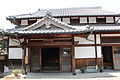
- Kōnomiya Shrine - Owari Okunitama-jinja shrine
- Dune
- Sobue Dune
- Tower
-
 Orizu Castle
 -
Shobata Castle
-
 Owari Kokubun temple
 -
 Yawase Kannon Temple
 -
 Kōnomiya Shrine
(Owari Okunitama-jinja shrine) -
 Sobue Dune


Sister city relations
This section needs additional citations for verification. (August 2016) |
 - Greece, Olympia, Greece
 – Chifeng, Inner Mongolia, China, since May 16, 1989[3]
Notable people from Inazawa
- Masaichi Kaneda – professional baseball player
- Junki Ito – professional baseball player
- Wataru Sakata – professional wrestler
References
- ^ "Japan opens 'tallest lift tower'". BBC News. 3 January 2008.
- ^ "Putting elevators to test". KONE Corporation. 17 April 2018.
- ^ "International Exchange". List of Affiliation Partners within Prefectures. Council of Local Authorities for International Relations (CLAIR). Archived from the original on 24 December 2015. Retrieved 21 November 2015.
{{cite web}}: Unknown parameter|deadurl=ignored (|url-status=suggested) (help)
External links
| Nagoya |
| |||
|---|---|---|---|---|
| Core cities | ||||
| Special city | ||||
| Cities | ||||
| Districts | ||||
| Former Districts | ||||
| International | |
|---|---|
| National | |
| Geographic | |