Letheringsett with Glandford
| Letheringsett with Glandford | |
|---|---|
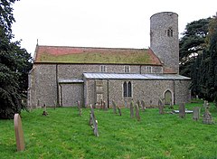
 St Andrew's Parish Church, Letheringsett | |
 Village of Letheringsett about 1910 | |
Location within Norfolk | |
| Area | 8.19 km2 (3.16 sq mi) |
| Population | 232 (2011 census)[1] |
| • Density | 28/km2 (73/sq mi) |
| • London | 126 mi (203 km) |
| Civil parish |
|
| District | |
| Shire county | |
| Region | |
| Country | England |
| Sovereign state | United Kingdom |
| Post town | HOLT |
| Postcode district | NR25 |
| Dialling code | 01263 |
| Police | Norfolk |
| Fire | Norfolk |
| Ambulance | East of England |
| UK Parliament | |
Letheringsett with Glandford is a civil parish in the English county of Norfolk. It includes the village of Letheringsett, along with the hamlet of Glandford.[2] The village straddles the A148 King’s Lynn to Cromer road. Letheringsett is 1.2 miles west of Holt, 32.2 west north east of King’s Lynn and 126 miles north north east of London. The nearest railway station is at Sheringham for the Bittern Line which runs between Sheringham, Cromer and Norwich. The nearest airport is Norwich International Airport.
Description
The village of Letheringsett is situated in the valley of the River Glaven and has two watermills, Letheringsett Brewery watermill which stands on the west side of the river next to the A148 road bridge and is now disused, and Letheringsett Watermill which lies 150 yards to the south. It is the last working watermill[citation needed] in the county of Norfolk, has won several prestigious awards for its flour production and is a tourist attraction.[3] Next to the Brewery watermill is the village pub, the King’s Head, which was built in the Georgian period.[citation needed]
Letheringsett Hall is a care home. It is a Grade II* listed building.[4]
Saint Andrew's Parish Church
The church of Letheringsett, St Andrew's, is one of 124 existing round-tower churches in Norfolk.
The church appears on a Royal Mail stamp issued on 21 June 1972 as part of a set on British Architecture (Village Churches).
The pub
The King's Head has won many awards such as family pub of the year. The pub has two bars and a restaurant and has a selection of real ale.
Notable people
- John Burrell (1762–1825), entomologist and Rector of Letheringsett from 1786 to 1825
- Herbert Hardy Cozens-Hardy, 1st Baron Cozens-Hardy (1838-1920), Liberal politician and judge
- Mary Hardy (1733–1809), diarist
References
- ^ "Civil Parish population 2011". Retrieved 31 August 2015.
- ^ OS Explorer map 24” (Edition A 1997) – “Norfolk Coast Central. ISBN 0-319-21726-4.
- ^ "EDP Food Awards". Eastern Daily Press. Retrieved 28 June 2009.
- ^ Historic England. "Letheringsett Hall (Grade II*) (1049832)". National Heritage List for England. Retrieved 23 August 2017.
External links
![]() Media related to Letheringsett with Glandford at Wikimedia Commons
Media related to Letheringsett with Glandford at Wikimedia Commons
- Website with photos of Letheringsett St. Andrew, a round-tower church
- History of Letheringsett watermill

