List of islands of Mexico

Coordinates: 24°13′17″N 109°52′14″W / 24.22139°N 109.87056°W / 24.22139; -109.87056
From Wikipedia, the free encyclopedia

This is an old revision of this page, as edited by Cdw1952 (talk | contribs) at 00:11, 15 August 2018 (→‎Islands on the continental shelf). The present address (URL) is a permanent link to this revision, which may differ significantly from the current revision.

This is an incomplete list of islands of Mexico.
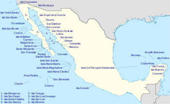
Islands of Mexico

Oceanic Islands (In the Pacific Ocean)

Oceanic Islands of the Pacific
Name Location Height Area
Clarion Island 18°21′32″N 114°43′19″W / 18.35889°N 114.72194°W / 18.35889; -114.72194 335 metres (1,099 ft) 19.80 square kilometres (7.64 sq mi)
Guadalupe Island 29°1′51″N 118°16′48″W / 29.03083°N 118.28000°W / 29.03083; -118.28000 1,298 metres (4,259 ft) 244 square kilometres (94 sq mi)
Revillagigedo Archipelago 18°49′N 112°46′W / 18.817°N 112.767°W / 18.817; -112.767 1,130 metres (3,707 ft) 157.81 square kilometres (60.93 sq mi)
Roca Partida 18°59′50″N 112°03′54″W / 18.99722°N 112.06500°W / 18.99722; -112.06500 34 metres (112 ft) 800 m2
Rocas Alijos 24°57′31″N 115°44′59″W / 24.95861°N 115.74972°W / 24.95861; -115.74972 34 metres (112 ft) <1000 m2
San Benedicto Island 19°18′16″N 110°48′52″W / 19.30444°N 110.81444°W / 19.30444; -110.81444 332 metres (1,089 ft) 10 square kilometres (3.9 sq mi)
Socorro Island 18°47′04″N 110°58′30″W / 18.78444°N 110.97500°W / 18.78444; -110.97500 1,150 metres (3,773 ft) 132 square kilometres (51 sq mi)

Islands on the continental shelf

Pacific Coast

Pacific Coast Islands
Name Location Height Area
Cedros 28°10′58″N 115°13′04″W / 28.18278°N 115.21778°W / 28.18278; -115.21778 348.3 square kilometres (134.5 sq mi)
Isla Coronados 32°24.5′N 117°14.75′W / 32.4083°N 117.24583°W / 32.4083; -117.24583
Isla Grande
Isla Magdalena 24°35′N 112°00′W / 24.583°N 112.000°W / 24.583; -112.000
Islas Marías Archipelago 21°31′N 106°29′W / 21.517°N 106.483°W / 21.517; -106.483 245 square kilometres (95 sq mi)
Isla Natividad 27°52′33″N 115°11′05″W / 27.87583°N 115.18472°W / 27.87583; -115.18472
Islas San Benito 28°18′12″N 115°35′24″W / 28.30333°N 115.59000°W / 28.30333; -115.59000 3.899 square kilometres (1.505 sq mi)
Isla San Martin 30°29′20.07″N 116°06′50.61″W / 30.4889083°N 116.1140583°W / 30.4889083; -116.1140583 125m
Santa Margarita 24°35′N 112°00′W / 24.583°N 112.000°W / 24.583; -112.000
Isla Todos Santos 31°47′59″N 116°47′20″W / 31.79972°N 116.78889°W / 31.79972; -116.78889

Gulf of California

Islands in Gulf of California
Name Location Height Area
Isla Altamura
Isla Ángel de la Guarda 29°15′36″N 113°22′13″W / 29.26000°N 113.37028°W / 29.26000; -113.37028 1,300 metres (4,265 ft) 931 square kilometres (359 sq mi)
Isla Aremar aka Isla Rasita 29°00′52.30″N 113°30′19.40″W / 29.0145278°N 113.5053889°W / 29.0145278; -113.5053889 tbd
Isla Ballena 24°28′55.97″N 110°24′15.60″W / 24.4822139°N 110.4043333°W / 24.4822139; -110.4043333 30 metres (98 ft)
Isla Bota - The Boot 29°00′38.69″N 113°30′51.92″W / 29.0107472°N 113.5144222°W / 29.0107472; -113.5144222 100 feet (30 m)
Isla Cabeza de Caballo - Head of the Horse 28°58′17.45″N 113°28′43.28″W / 28.9715139°N 113.4786889°W / 28.9715139; -113.4786889 331 feet (101 m)
Isla Calavera - The Skull 29°01′39.60″N 113°29′55.50″W / 29.0276667°N 113.4987500°W / 29.0276667; -113.4987500 100 feet (30 m)
Isla Cerraja - The Lock 28°59′48.33″N 113°31′9.10″W / 28.9967583°N 113.5191944°W / 28.9967583; -113.5191944 49 feet (15 m)
Isla Carmen 25°12′01.0″N 110°41′53.0″W / 25.200278°N 110.698056°W / 25.200278; -110.698056 37,000 acres (58 sq mi)
Isla Cerralvo aka Jacques Cousteau Island 24°13′17″N 109°52′14″W / 24.22139°N 109.87056°W / 24.22139; -109.87056
Isla Coronadito - Volcano (diminutive) 29°05′54.30″N 113°31′43.10″W / 29.0984167°N 113.5286389°W / 29.0984167; -113.5286389 tbd
Isla Coronado (aka. Smith Island) 29°04′26.19″N 113°30′31.34″W / 29.0739417°N 113.5087056°W / 29.0739417; -113.5087056 1,554 feet (474 m) tbd
Isla Costanazo 29°59′36.4″N 114°23′23.7″W / 29.993444°N 114.389917°W / 29.993444; -114.389917 tbd
Isla Danzante 25°47′11.06″N 111°15′3.85″W / 25.7864056°N 111.2510694°W / 25.7864056; -111.2510694 320 metres (1,050 ft)
Isla Espíritu Santo 24°28′17″N 110°19′57″W / 24.47139°N 110.33250°W / 24.47139; -110.33250
Isla El Muerto 30°5′19.2″N 114°32′35.8″W / 30.088667°N 114.543278°W / 30.088667; -114.543278 490 feet (149 m)
Isla Flecha - The Arrow 29°00′18.78″N 113°31′20.28″W / 29.0052167°N 113.5223000°W / 29.0052167; -113.5223000 203 feet (62 m)
Isla Huivili - Long Neck 27°03′43″N 109°58′37″W / 27.062°N 109.977°W / 27.062; -109.977
Isla Jalme 30°01′8.6″N 114°28′23.2″W / 30.019056°N 114.473111°W / 30.019056; -114.473111 tbd
Isla Jorobado - The Hunchback 29°00′43.90″N 113°31′27.50″W / 29.0121944°N 113.5243056°W / 29.0121944; -113.5243056 tbd
Isla La Ventana - The Window 28°59′46.09″N 113°30′35.08″W / 28.9961361°N 113.5097444°W / 28.9961361; -113.5097444 112 feet (34 m)
Isla Llave - The Key 28°59′56.10″N 113°31′13.80″W / 28.9989167°N 113.5205000°W / 28.9989167; -113.5205000 tbd
Isla Lobos
Isla of Rosemary Lambert
Isla Región 30°1′8.8″N 114°27′58.6″W / 30.019111°N 114.466278°W / 30.019111; -114.466278
Isla Saliaca
Isla Miramar
Isla Mitlan 29°04′1.44″N 113°31′3.90″W / 29.0670667°N 113.5177500°W / 29.0670667; -113.5177500 tbd
Isla Montserrat
Isla Partida 24°33′45″N 110°22′42″W / 24.56250°N 110.37833°W / 24.56250; -110.37833
Isla Pata - The Paw 29°00′51.64″N 113°30′50.85″W / 29.0143444°N 113.5141250°W / 29.0143444; -113.5141250 tbd
Isla Patos - Ducks 29°16′19.1″N 112°27′37.3″W / 29.271972°N 112.460361°W / 29.271972; -112.460361
Isla Piojo - Lice 29°01′4.43″N 113°27′54.58″W / 29.0178972°N 113.4651611°W / 29.0178972; -113.4651611 223 feet (68 m)
Isla Raza
Isla Sacuo 30°3′4.8″N 114°29′21.3″W / 30.051333°N 114.489250°W / 30.051333; -114.489250
Isla San Diego 25°12′01″N 110°41′53″W / 25.20028°N 110.69806°W / 25.20028; -110.69806
Isla San Esteban 28°41′51″N 112°34′39″W / 28.69750°N 112.57750°W / 28.69750; -112.57750
Isla San Francisco 24°49′50.90″N 110°34′29.25″W / 24.8308056°N 110.5747917°W / 24.8308056; -110.5747917
Isla San Ignacio
Isla San Lorenzo
Isla San Luis 29°58′17.41″N 114°24′26.30″W / 29.9715028°N 114.4073056°W / 29.9715028; -114.4073056 150 metres (492 ft)
Isla San Luis Gonzaga 29°48′51.3″N 114°23′4.1″W / 29.814250°N 114.384472°W / 29.814250; -114.384472
Isla San Marcos
Isla San Pedro Nolasco 27°57′59″N 111°22′42″W / 27.96639°N 111.37833°W / 27.96639; -111.37833
Isla Santa Catalina 25°39′9.53″N 110°46′51.25″W / 25.6526472°N 110.7809028°W / 25.6526472; -110.7809028
Island Santa Cruz
Isla Santa Ines
Isla Tachichilte
Isla Tiburón 28°59′20″N 112°22′23″W / 28.98889°N 112.37306°W / 28.98889; -112.37306
Isla Tortuga 27°26′42″N 111°52′51″W / 27.44500°N 111.88083°W / 27.44500; -111.88083
Islas Twins aka Islas Los Gemelitos 28°57′20.10″N 113°28′43.70″W / 28.9555833°N 113.4788056°W / 28.9555833; -113.4788056

Gulf of Mexico / Caribbean

Islands in the Gulf of Mexico or Caribbean Sea
Name Location Height Area
Bermeja (Phantom) 22°38′47.6″N 90°51′23.2″W / 22.646556°N 90.856444°W / 22.646556; -90.856444
Isla Blanca, Quintana Roo 21°24′37″N 86°48′37.9″W / 21.41028°N 86.810528°W / 21.41028; -86.810528
Carmen Island 18°38′N 91°50′W / 18.633°N 91.833°W / 18.633; -91.833 3m 28,449 acres (44.452 sq mi)
Isla Contoy 21°30′23″N 86°47′54″W / 21.50639°N 86.79833°W / 21.50639; -86.79833 3.17 square kilometres (1.22 sq mi)
Cozumel 20°25′N 86°55′W / 20.417°N 86.917°W / 20.417; -86.917 14m 647.33 square kilometres (249.94 sq mi)
Cayos Arcas 22°06′52.5″N 91°23′53.2″W / 22.114583°N 91.398111°W / 22.114583; -91.398111 56.3 acres (0.0880 sq mi)
Great Island
Isla Holbox 21°32′16″N 87°13′12″W / 21.53778°N 87.22000°W / 21.53778; -87.22000 55.95 square kilometres (21.60 sq mi)
Isla Mujeres 21°14′N 86°44′W / 21.233°N 86.733°W / 21.233; -86.733
Arrecife Alacranes 22°22′58″N 89°40′57.8″W / 22.38278°N 89.682722°W / 22.38278; -89.682722
Western Triangle Keys

Inner Islands

Lake Chapala

Lake Pátzcuaro

Lake Texcoco

See also

External links

Media related to Islands of Mexico at Wikimedia Commons