Luanping County
Appearance
Luanping County
滦平县 | |
|---|---|
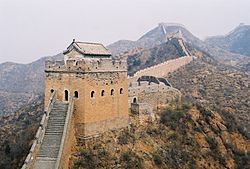
 Jinshanling Great Wall | |
 | |
| Country | People's Republic of China |
| Province | Hebei |
| Prefecture-level city | Chengde |
| County seat | Luanping Town (滦平镇) |
| Area | |
• Total | 3,195 km2 (1,234 sq mi) |
| Elevation | 515 m (1,690 ft) |
| Population | |
• Total | 340,000 |
| • Density | 110/km2 (280/sq mi) |
| Time zone | UTC+8 (China Standard) |
| Postal code | 068250 |
| Area code | 0314 |
| Website | http://www.lpx.gov.cn/ |
Luanping County (simplified Chinese: 滦平县; traditional Chinese: 灤平縣; pinyin: Luánpíng Xiàn) is a county of northeastern Hebei province, China, with the Great Wall demarcating its border with Miyun County, Beijing. It is under the administration of Chengde City, and has a population of 340,000[when?] residing in an area of 3,195 km2 (1,234 sq mi). The G45 Daqing–Guangzhou Expressway, China National Highways 101 and 112, and the Beijing–Tongliao Railway pass through the county.
Administrative divisions
There is 1 subdistrict, 7 towns, 4 townships, and 9 ethnic townships under the county's administration.[1]
The only subdistrict is Zhongxing Road Subdistrict (中兴路街道)
|
Towns:
|
Townships:
|
References
- ^ 2011年统计用区划代码和城乡划分代码:滦平县 (in Chinese). National Bureau of Statistics of the People's Republic of China. Retrieved 2012-07-19.
