
Madan Upazila
Madan
মদন | |
|---|---|
 Madan Location in Bangladesh | |
| Coordinates: 24°43′N 90°58′E / 24.717°N 90.967°E | |
| Country | |
| Division | Mymensingh Division |
| District | Netrokona District |
| Area | |
| • Total | 225.85 km2 (87.20 sq mi) |
| Population (1991) | |
| • Total | 117,613 |
| • Density | 520/km2 (1,300/sq mi) |
| Time zone | UTC+6 (BST) |
| Website | Official Map of Madan |
Madan (Bengali: মদন) is an upazila of Netrokona District[1] in the Division of Mymensingh, Bangladesh.
Geography
Madan is located at 24°43′00″N 90°58′00″E / 24.7167°N 90.9667°E. It has 21,808 households and total area 225.85 km².
Demographics
As of the 1991 Bangladesh census, Madan has a population of 117613. Males constitute 50.99% of the population, and females 49.01%. This Upazila's eighteen up population is 58127. Madan has an average literacy rate of 18.7% (7+ years), and the national average of 32.4% literate.[2]
Administration
Madan has 1 Pourashava, 8 Unions/Wards, 95 Mauzas/Mahallas, and 120 villages.
See also
Gallary
-
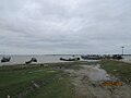 Uchitpur Ghat at Madan.
 -
 Mogra River from the bridge at Madan Upazila.


References
- ^ Syed Marufuzzaman (2012), "Madan Upazila", in Sirajul Islam and Ahmed A. Jamal (ed.), Banglapedia: National Encyclopedia of Bangladesh (Second ed.), Asiatic Society of Bangladesh
- ^ "Population Census Wing, BBS". Archived from the original on 27 March 2005. Retrieved 10 November 2006.
Capital: Netrokona | ||
| Upazilas | ||
| Constituencies | ||
| Attractions and sites | ||
| History | ||
| Inhabited areas | ||
| Rivers | ||
| Educational institutions | ||
| Transport | ||
Headquarters: Mymensingh | ||
| Jamalpur District |  | |
| Mymensingh District | ||
| Netrokona District | ||
| Sherpur District | ||
This Mymensingh Division location article is a stub. You can help Wikipedia by expanding it. |