Main (river): Difference between revisions
Ptbotgourou (talk | contribs) m robot Adding: be:Рака Майн |
No edit summary |
||
| Line 32: | Line 32: | ||
The river has gained enormous importance as a vital part of European "[[Pan-European corridors|Corridor VII]]", the inland waterway link from [[North Sea|the North Sea]] to the [[Black Sea]].<ref>{{cite web | url=http://www.noordersoft.com/indexen.html | title=NoorderSoft Waterways Database | accessdate=2007-10-24}}<!-- This link is actually somewhat borderline. We can probably do better than this. --></ref> |
The river has gained enormous importance as a vital part of European "[[Pan-European corridors|Corridor VII]]", the inland waterway link from [[North Sea|the North Sea]] to the [[Black Sea]].<ref>{{cite web | url=http://www.noordersoft.com/indexen.html | title=NoorderSoft Waterways Database | accessdate=2007-10-24}}<!-- This link is actually somewhat borderline. We can probably do better than this. --></ref> |
||
this is all bakwas..=D |
|||
==References== |
==References== |
||
{{reflist}} |
{{reflist}} |
||
Revision as of 16:21, 24 May 2010
| Main | |
|---|---|
 | |
 | |
| Physical characteristics | |
| Mouth | Rhine 49°59′40″N 8°17′36″E / 49.99444°N 8.29333°E |

The Main (German pronunciation: [ˈmaɪn]) is a river in Germany, 524 km (329 miles) long (including the White Main, 574 km (357 mi)), and it is one of the more significant tributaries of the Rhine. The Main flows through the German states of Bavaria, Baden-Württemberg (forming the border with Bavaria for some distance) and Hesse. Its watershed competes with the Danube for water; as a result, many of its boundaries are identical with those of the European Watershed. The Main begins near Kulmbach at the joining of its two headstreams, the Red Main (Roter Main) and the White Main (Weißer Main). The Red Main rises in the Frankish Alb, 50 km (30 mi) in length, and runs through Creussen and Bayreuth. The White Main rises in the mountains of the Fichtelgebirge; it is 41 km (25 mi) long. In its upper and middle section it runs in valleys of the German Highlands. In its lower section it crosses the Lower Main Lowlands (Hanau-Seligenstadt Basin and northern Upper Rhine Plain) where it discharges into the Rhine River. Major tributaries of the Main are the Regnitz, the Fränkische Saale, the Tauber, and the Nidda.
The name derives from the Latin Moenus or Menus, and is not related to the name of the city Mainz (Latin Moguntiacum).
Navigation
The Main is navigable for shipping from its mouth at the Rhine close to Mainz for 396 km to Bamberg. Since 1992, the Main has been connected to the Danube via the Rhine-Main-Danube Canal and the highly regulated Altmühl river. The river has been canalized with 34 large locks (300 m × 12 m (984 ft × 39 ft)) to allow CEMT class V (110 m × 11.45 m (360.9 ft × 37.6 ft)) vessels to navigate the total length of the river. The 16 locks in the adjacent Rhine-Main-Danube Canal and the Danube itself are of the same dimensions.
-
The Main in Frankfurt
-
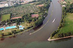
Confluence into the Rhine.
Ports and municipalities
Around Frankfurt are several large inland ports. Because the river is rather narrow on many of the upper reaches, navigation with larger vessels and push convoys requires great skill.
The largest cities along the Main are Frankfurt am Main and Würzburg. The Main also passes the following towns and cities: Burgkunstadt, Lichtenfels, Bad Staffelstein, Eltmann, Haßfurt, Schweinfurt, Volkach, Kitzingen, Marktbreit, Ochsenfurt, Karlstadt, Gemünden, Lohr, Marktheidenfeld, Wertheim, Miltenberg, Obernburg, Aschaffenburg, Seligenstadt, Hainburg, Hanau, Offenbach, Hattersheim, Flörsheim, and Rüsselsheim.
The river has gained enormous importance as a vital part of European "Corridor VII", the inland waterway link from the North Sea to the Black Sea.[1] this is all bakwas..=D
References
- ^ "NoorderSoft Waterways Database". Retrieved 2007-10-24.
External links
- Main River Website on the River Main by the Tourist Board of Franconia. Template:En icon


