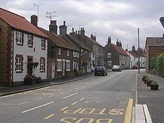
Muston, North Yorkshire
| Muston | |
|---|---|
 Muston | |
| Population | 339 (2011 census)[1] |
| OS grid reference | TA096796 |
| • London | 185 mi (298 km) S |
| Civil parish |
|
| District | |
| Shire county | |
| Region | |
| Country | England |
| Sovereign state | United Kingdom |
| Post town | FILEY |
| Postcode district | YO14 |
| Dialling code | 01723 |
| Police | North Yorkshire |
| Fire | North Yorkshire |
| Ambulance | Yorkshire |
| UK Parliament | |
Muston is a village and civil parish, in the Scarborough district of North Yorkshire, England. The village is situated 1.5 miles (2.4 km) south-west from the centre of the coastal town of Filey, and on the A1039 road.
History
According to the A Dictionary of British Place Names 'Muston' is derived from either the 12th-century "mouse infected farmstead", or a "farmstead of a man called Musi", being an Old Norse person name with the Old English 'tun' (farmstead or enclosure).[2]
Muston is listed in the Domesday Book as "Mustone", in the Torbar Hundred of the East Riding of Yorkshire. The settlement included seven households, twenty-one villagers, six smallholders, and ten ploughlands. In 1066 Karli son of Karli held the Lordship, this transferring in 1086 to Gilbert of Ghent who also became Tenant-in-chief to King William I.[3]
In 1823 Muston was a village and civil parish in the Wapentake of Dickering in the East Riding of Yorkshire. The ecclesiastical parish was a Vicarage held by the Archdeacon of Cleveland, Francis Wrangham. Population at the time was 350. Occupations included fourteen farmers, two butchers, two carpenters, three grocers, a tanner, a bricklayer, a corn miller, a shoemaker, an earthenware dealer, a tailor, a blacksmith, and the landlady of The Cross Keys public house. A daily coach linked Muston to Hull and Scarborough. A carrier operated between the village and Bridlington, Hunmanby and Filey twice weekly.[4]
The 1863 parish church of All Saints' was designated a Grade II listed building in 1966.[5]
There is a derelict windmill on the outskirts of the village, just off the A1039 road. References to a mill first appear in 1341.[citation needed] The current mill is thought to have been built in 1826 and was in use until 1932.[6]
Community
According to the 2011 UK Census, Muston parish had a population of 339,[1] an increase on the 2001 UK census figure of 325.[7]
Muston is on the Yorkshire Wolds Way National Trail, a long distance footpath.
In July and August, Muston hosts its annual week-long scarecrow festival.[8]
The village cricket team, Muston CC, plays in the Derwent Valley 'A' league.[9]
Gallery
- widths="180px"
-
All Saints' Church, Muston
-
Scarecrow Festival 2008
References
- ^ a b "Key Figures for 2011 Census: Key Statistics: Area: Muston CP (Parish)". Neighbourhood Statistics. Office for National Statistics. Retrieved 9 February 2013.
- ^ Mills, Anthony David (2003); A Dictionary of British Place Names, Oxford University Press, revised edition (2011), p. 338. ISBN 019960908X
- ^ "Muston", Open Domesday, University of Hull. Retrieved 10 December 2014
- ^ Baines, Edward (1823): History, Directory and Gazetteer of the County of York, p. 370
- ^ Historic England. "Church of All Saints, King Street (1316466)". National Heritage List for England. Retrieved 10 December 2014.
- ^ Whitworth, A (2002). Tyke Towers Yorkshire's Windmills. Landy Publishing. ISBN 1-87289557-3.
- ^ "2001 Census: Key Statistics: Parish Headcounts: Area: Muston CP (Parish)". Neighbourhood Statistics. Office for National Statistics. Retrieved 7 July 2008.
- ^ "Muston Scarecrow Festival". North Yorkshire — Entertainment. BBC. Retrieved 5 June 2009.
- ^ "Derwent Valley Cricket League Division 'A'". Scarborough Derwent Valley Cricket League. Retrieved 6 February 2014.
External links
 Media related to Muston, North Yorkshire at Wikimedia Commons
- All Saints Church, Muston
- Muston Scarecrow Festival (Gallery)
- "The Ancient Parish of Muston", Genuki


