Paraíso (canton)
Appearance
Paraíso | |
|---|---|
Cantón
| |
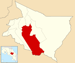
 Location of Paraíso Canton in Cartago Province | |
| Country | Costa Rica |
| Province | Alajuela |
| Capital | Paraíso |
| Area | |
• Total | 411.91 km2 (159.04 sq mi) |
| Population (June 2013) | |
• Total | 59,259 |
| • Density | 140/km2 (370/sq mi) |
Paraíso is the name of the second canton in the province of Cartago in Costa Rica.[1] The canton covers an area of 411.91 square kilometres (159.04 sq mi),[2] and has a population of 59,259 (estimate as of 2013).[3]
The capital city of the canton is also called Paraíso.
Geography
Paraíso is an elongated canton that stretches southeast from its capital city to encompass a swatch of the Cordillera de Talamanca (Talamanca Mountain Range).
Districts
The canton of Paraíso is subdivided into five districts (distritos)[1]
| District | Population |
|---|---|
| Paraíso | 20,725 |
| Santiago | 5,954 |
| Orosi | 9,490 |
| Cachí | 5,559 |
| Llanos de Santa Lucía | 17,531 |
History
Paraíso was first mentioned as a canton in a decree dated December 7, 1848.
References
- ^ a b "División Territorial Administrativa de Costa Rica" (PDF) (in Spanish). Instituto de Fomento y Asesoria Municipal (IFAM). 5 May 2009.
{{cite web}}: Italic or bold markup not allowed in:|publisher=(help) - ^ Instituto Geográfico Nacional (IGN), 2001.
- ^ Estadísticas Vitales 2013 - INEC
9°50′N 83°52′W / 9.833°N 83.867°W
