
Phitsanulok Airport
Phitsanulok Airport ท่าอากาศยานพิษณุโลก | |||||||||||
|---|---|---|---|---|---|---|---|---|---|---|---|
_%E0%B8%97%E0%B9%88%E0%B8%B2%E0%B8%AD%E0%B8%B2%E0%B8%81%E0%B8%B2%E0%B8%A8%E0%B8%A2%E0%B8%B2%E0%B8%99%E0%B8%9E%E0%B8%B4%E0%B8%A9%E0%B8%93%E0%B8%B8%E0%B9%82%E0%B8%A5%E0%B8%81_-_IMG_02.jpg) | |||||||||||
| Summary | |||||||||||
| Airport type | Public | ||||||||||
| Owner | Royal Thai Air Force | ||||||||||
| Operator | Department of Airports | ||||||||||
| Serves | Phitsanulok, Phitsanulok province, Thailand | ||||||||||
| Opened | 1941 | ||||||||||
| Elevation AMSL | 154 ft / 47 m | ||||||||||
| Coordinates | 16°46′23″N 100°16′56″E / 16.77306°N 100.28222°E | ||||||||||
| Maps | |||||||||||
 | |||||||||||
 PHS/VTPP Location of airport in Thailand | |||||||||||
 | |||||||||||
| Runways | |||||||||||
| |||||||||||
| Statistics (2023) | |||||||||||
| |||||||||||
Phitsanulok Airport (IATA: PHS, ICAO: VTPP) is an airport serving Phitsanulok, a city in the Phitsanulok province of northern Thailand. The airport is south of the city's downtown area.
Airlines and destinations[edit]
In 2019 it handles 689,392 passengers, 5,661 flights and 150,980 kilograms (332,850 lb) of cargo.[3]
| Airlines | Destinations |
|---|---|
| Nok Air | Bangkok–Don Mueang |
| Thai AirAsia | Bangkok–Don Mueang |
| Thai Lion Air | Bangkok–Don Mueang |
Miscellaneous[edit]
To the right and to the left of the tarmac are two decommissioned Boeing 747 jets from Orient Thai Airlines. The airline ceased operations and filed for bankruptcy in October 2018.
-
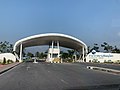 Entrance gate to Phitsanulok Airport (2022)
 -
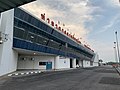 Terminal of Phitsanulok Airport (2022)
 -
 Nok-Air Boeing 737-400 at Phitsanulok (2011)
 -
 Decommissioned Orient Thai Airlines Boeing 747 (2011)
 -
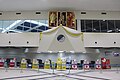 Phitsanulok Airport check in counters (2019)
_%E0%B8%97%E0%B9%88%E0%B8%B2%E0%B8%AD%E0%B8%B2%E0%B8%81%E0%B8%B2%E0%B8%A8%E0%B8%A2%E0%B8%B2%E0%B8%99%E0%B8%9E%E0%B8%B4%E0%B8%A9%E0%B8%93%E0%B8%B8%E0%B9%82%E0%B8%A5%E0%B8%81_-_IMG_16.jpg)
_%E0%B8%97%E0%B9%88%E0%B8%B2%E0%B8%AD%E0%B8%B2%E0%B8%81%E0%B8%B2%E0%B8%A8%E0%B8%A2%E0%B8%B2%E0%B8%99%E0%B8%9E%E0%B8%B4%E0%B8%A9%E0%B8%93%E0%B8%B8%E0%B9%82%E0%B8%A5%E0%B8%81_-_IMG_03.jpg)
_at_Phitsanulok_Airport.jpg)

Notes[edit]
References[edit]
- ^ "Airport information for VTPP". World Aero Data. Archived from the original on 2019-03-05.
{{cite web}}: CS1 maint: unfit URL (link) Data current as of October 2006. Source: DAFIF. - ^ Airport information for PHS at Great Circle Mapper. Source: DAFIF (effective October 2006).
- ^ Phitsanulok Provincial Statistical Report 2562-2019: Statistics of Domestic Air Transport:2019. Phitsanulok Provincial Statistical Office (Report). National Statistical Office (NSO). 2020. p. 147. ISSN 1905-8314.
External links[edit]
 Phitsanulok travel guide from Wikivoyage
- Phitsanulok Airport, Dept of Civil Aviation
- Current weather for VTPP at NOAA/NWS
- Accident history for PHS at Aviation Safety Network