RAF Bourn
This article needs additional citations for verification. (February 2013) |
RAF Bourn | |||||||||||||||||||||||||||
|---|---|---|---|---|---|---|---|---|---|---|---|---|---|---|---|---|---|---|---|---|---|---|---|---|---|---|---|
 Corporal J Patterson records the 203rd sortie on the operations tally of De Havilland Mosquito B Mark IX, LR503 'GB-F', of 'C' Flight, No. 105 Squadron RAF at Bourn, Cambridgeshire, watched by its crew, Flight Lieutenant T P Lawrenson (pilot, far left) and Flight Lieutenant D W Allen RNZAF (navigator, right). "F-Bar for Freddie" went on to complete 213 sorties, a Bomber Command record. | |||||||||||||||||||||||||||
| Summary | |||||||||||||||||||||||||||
| Airport type | Military | ||||||||||||||||||||||||||
| Owner | Air Ministry | ||||||||||||||||||||||||||
| Operator | Royal Air Force | ||||||||||||||||||||||||||
| Location | Bourn, Cambridgeshire | ||||||||||||||||||||||||||
| Built | 1940 | ||||||||||||||||||||||||||
| In use | 1941-1948[1] | ||||||||||||||||||||||||||
| Elevation AMSL | 236 ft / 72 m | ||||||||||||||||||||||||||
| Coordinates | 52°12′58″N 000°02′26″W / 52.21611°N 0.04056°W | ||||||||||||||||||||||||||
| Map | |||||||||||||||||||||||||||
 | |||||||||||||||||||||||||||
| Runways | |||||||||||||||||||||||||||
| |||||||||||||||||||||||||||
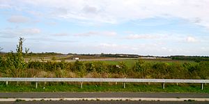
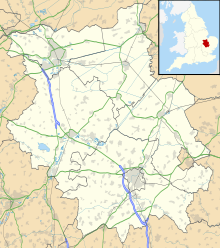
Royal Air Force Bourn or more simply RAF Bourn is a former Royal Air Force station located 2 miles (3.2 km) north of Bourn, Cambridgeshire and 6.9 miles (11.1 km) west of Cambridge, Cambridgeshire, England.
History

Bourn Airfield was constructed for RAF Bomber Command in 1940 as a satellite airfield for nearby RAF Oakington.[1] It was used by No. 101 Squadron RAF Vickers Wellingtons for training purposes from 23 July 1941, and from October of that year 101 and 7 Squadrons used the airfield when Oakington became unavailable.[2]
On 9 April 1941, the airfield was subjected to the first of four raids when a Junkers Ju88C strafed the airfield buildings and bombed the runway; however, little damage was done and there were no injuries. Two more raids on 8 and 23 May 1944 were made, the latter damaging two parked de Havilland Mosquitoes.
As the strategic bombing offensive intensified, the losses mounted. By the time of the last operational sortie on 4 April 1945, a total of 164 aircraft had been lost, either from the squadrons based at Bourn or from others trying, and failing, to land on the field. The average age of aircrew was 23 and over a third of these were under 20 years of age. Of the 886 listed names, 648 were killed and many of the 35 injured subsequently died of their wounds. The number killed was probably greater than that of the entire population of the village at the time.
97 Squadron's Avro Lancasters were replaced by the Mosquito IXs of 105 Sqn in March 1944. These Oboe-equipped aircraft were able to identify targets with great precision and then mark them accurately.[3]
In December 1944, 162 Squadron was formed at Bourn with Canadian-built Mosquito XXs and XXVs which flew almost nightly to Berlin, target-marking for the Light Night Strike Force.[4] The two squadrons operated together from Bourn for much of the rest of the war.
From 1941 to 1945, damaged Short Stirlings were repaired and test-flown from Bourn. These were transported to the airfield from the Sebro factory near Madingley which later continued its work with RAF and United States Army Air Forces (USAAF), Consolidated B-24 Liberators.[4] The Bourn and Madingley units together employed up to 4,500 personnel.
The following units were here at some point:[5]
- No. 23 Operational Training Unit RAF
- No. 1323 Automatic Gun Laying Turret Flight RAF
- No. 1409 Meteorological Flight RAF
- No. 1696 (Bomber) Defence Training Flight RAF
- No. 2708 Squadron RAF Regiment
Post-war
The airfield was passed on to RAF Maintenance Command in 1947. By 1948, the station was closed and the last sections were sold off for agricultural use in 1961.[6]
Current use

Now the Rural Flying Corps uses part of the runway for light aircraft; small industrial developments occupy other areas of the site. On Bank Holidays, Bourn Market uses much of the old runways for stalls.[7]
See also
References
- ^ a b Falconer 1995, p. 20.
- ^ Bowyer 1979, p. 72.
- ^ Bowyer 1979, p. 70.
- ^ a b Bowyer 1979, p. 73.
- ^ "Bourn". Airfields of Britain Conservation Trust. Retrieved 3 June 2016.
- ^ "RAF Bourn". Bourn. Archived from the original on 27 February 2013. Retrieved 1 October 2012.
{{cite web}}: Unknown parameter|deadurl=ignored (|url-status=suggested) (help) - ^ "Welcome to The Rural Flying Corps". Rural Flying Corps. Archived from the original on 22 July 2012. Retrieved 1 October 2012.
{{cite web}}: Unknown parameter|deadurl=ignored (|url-status=suggested) (help)
Bibliography
- Falconer, Jonathan. RAF Bomber Airfields of World War 2. Shepperton, Surrey, UK: Ian Allan Publishing, 1995. ISBN 0 7110 2080 9.
- Bowyer, Michael. Wartime military airfields of East Anglia. Cambridge, Cambridgeshire, UK: Patrick Stephens, 1979. ISBN 0 85059 335 2.

