Remaisnil
Appearance
From Wikipedia, the free encyclopedia
This is an old revision of this page, as edited by EP111 (talk | contribs) at 18:21, 24 May 2018 (ibx img). The present address (URL) is a permanent link to this revision, which may differ significantly from the current revision.
Commune in Hauts-de-France, France
Remaisnil | |
|---|---|
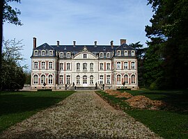
 The chateau in Remaisnil | |
| Coordinates: 50°12′03″N 2°14′46″E / 50.2008°N 2.2461°E / 50.2008; 2.2461 | |
| Country | France |
| Region | Hauts-de-France |
| Department | Somme |
| Arrondissement | Amiens |
| Canton | Doullens |
| Intercommunality | CC Territoire Nord Picardie |
| Government | |
| • Mayor (2001–2008) | Bernard Joncquet |
| Area 1 | 2.92 km2 (1.13 sq mi) |
| Population (2006) | 38 |
| • Density | 13/km2 (34/sq mi) |
| Time zone | UTC+01:00 (CET) |
| • Summer (DST) | UTC+02:00 (CEST) |
| INSEE/Postal code | 80666 /80600 |
| Elevation | 65–153 m (213–502 ft) (avg. 154 m or 505 ft) |
| 1 French Land Register data, which excludes lakes, ponds, glaciers > 1 km2 (0.386 sq mi or 247 acres) and river estuaries. | |
Remaisnil is a commune in the Somme department in Hauts-de-France in northern France. The village contains the Château de Remaisnil, which was owned by Jules Elby and Laura Ashley. In the field across from the mansion, remnants of a German V-1 Flying Bomb launch site are visible as well.
Geography
Remaisnil is situated 15 miles (24 km) northeast of Abbeville, on the D459 road
Population
| 1962 | 1968 | 1975 | 1982 | 1990 | 1999 | 2006 |
|---|---|---|---|---|---|---|
| 48 | 54 | 45 | 53 | 40 | 35 | 38 |
| Starting in 1962: Population without duplicates | ||||||
See also
References
External links
Wikimedia Commons has media related to Remaisnil.
- Remaisnil on the Quid website Template:Fr
- Remaisnil on the Communauté de Communes du Doullennais website Template:Fr
- Portail du Syndicat Mixte des Vals d'Authie, Nièvre et Somme Doullens and communes Template:Fr
Retrieved from "https://en.wikipedia.org/w/index.php?title=Remaisnil&oldid=842795449"
Hidden categories:


