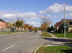
Rouge, Toronto
Rouge | |
|---|---|
Neighbourhood | |
 Old Finch Avenue near the Toronto Zoo | |
 Location of Rouge within Toronto | |
| Coordinates: 43°49′15″N 79°12′22″W / 43.82083°N 79.20611°W | |
| Country | |
| Province | |
| City | |
| Community | Scarborough |
| Changed Municipality | 1998 Toronto from |
| Government | |
| • MP | Gary Anandasangaree (L) |
| • MPP | Raymond Cho (C) Tracey MacCharles (L) |
| • Councillor | Vacant |
Rouge is a neighbourhood in the northeastern area of Toronto, Ontario, within the former city of Scarborough. It is Toronto's largest neighbourhood by surface area, however unlike other neighbourhoods, most of its area remains undeveloped due to the presence of Rouge Park.
Location and features
It is bounded on the north by Steeles Avenue East, on the east by the Pickering Town Line and the Rouge River, on the south by Lake Ontario, and on the west by Port Union Road, Kingston Road, Highway 401, Morningside Avenue, Finch Avenue East, and Markham Road. It is one of the largest neighbourhoods officially recognized by the City of Toronto, and is dominated by the Rouge River, its tributaries, and associated wilderness areas. North of Sheppard Avenue the neighbourhood has a strong suburban quality, with seventy-four percent of households single-family residences.
Subdivisions
Beyond its official categorization, Rouge can be subdivided into smaller neighbourhoods more commonly known as West Rouge, Rouge Hill, and Hillside, among others. The Toronto Zoo and Rouge Valley are major points of interest in the neighbourhood
Education
Schools
- Joseph Howe Senior Public School - A public elementary school located on winter Gardens Trail. It is grades seven and eight and West Rouge Junior Public School, William G Davis Public School, Centennial Public school, Charlottetown Public School all feed into Howe.
- Rouge Valley Public School
- St Dominic Savio Catholic School
- Sir Oliver Mowat Collegiate Institute - A public highschool (for grades 9 - 12) located near the intersection of Port Union Road and Lawrence Avenue East.
- John G. Diefenbaker PS
- St Jean de Brebeuf Catholic School
- Chief Dan George Public School - Kindergarten - Grade 8
Although there are no public separate high schools in Rouge Hill, many of students in that neighborhood usually attend St. John Paul II Catholic Secondary School and St. Mother Teresa Catholic Academy in most cases.
