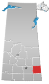
Rural Municipality of Rocanville No. 151
Rocanville No. 151 (2006 Population 554) is a rural municipality in south-eastern Saskatchewan, Canada encompassing 758.64 square kilometers in area. The rural municipality maintains its office in Rocanville, Saskatchewan.[1] The rural municipality in conjunction with the provincial government is in charge of maintenance of highways in its area. As well, the municipality provides policing, fire protection and municipal governance for the rural district, with a reeve as its administrator. The historic Fort Espérance is located within the rural municipality. Agriculture is the major industry in the rural municipality.
Statistics
| Population |
|---|
| Land area |
| Population density |
| Median age |
| Private dwellings |
| Median household income |
Transportation
The Rocanville Airport is a private airport owned by Potash Corporation of Saskatchewan located within the rural municipality.
References
- ^ Saskatchewan Municipal Database
- ^ "2006 Community Profiles". 2006 Canadian Census. Statistics Canada. August 20, 2019.
- ^ "2001 Community Profiles". 2001 Canadian Census. Statistics Canada. July 18, 2021.

