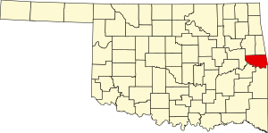
Sequoyah County, Oklahoma
This article needs additional citations for verification. (August 2008) |
Sequoyah County | |
|---|---|
 Location within the U.S. state of Oklahoma | |
 Oklahoma's location within the U.S. | |
| Coordinates: 35°30′N 94°45′W / 35.5°N 94.75°W | |
| Country | |
| State | |
| Founded | 1907 |
| Seat | Sallisaw |
| Area | |
| • Total | 715 sq mi (1,850 km2) |
| • Land | 674 sq mi (1,750 km2) |
| • Water | 41 sq mi (110 km2) 5.74% |
| Population (2000) | |
| • Total | 38,972 |
| • Density | 60/sq mi (22/km2) |
Sequoyah County is a county located in the U.S. state of Oklahoma. It is part of the Fort Smith, Arkansas-Oklahoma Metropolitan Statistical Area. As of 2000, the population was 38,972. Its county seat is SallisawTemplate:GR.
History
Sequoyah County was created in 1907 when Oklahoma became a state. It was named after Sequoyah, who created the Cherokee syllabary.
Geography
According to the U.S. Census Bureau, the county has a total area of 1,852 km² (715 mi²). 1,745 km² (674 mi²) of it is land and 106 km² (41 mi²) of it (5.74%) is water.
Cities and towns
Adjacent counties
- Cherokee County & Adair County (north)
- Crawford County, Arkansas (east)
- Sebastian County, Arkansas (southeast)
- Le Flore County (south)
- Haskell County (southwest)
- Muskogee County (west)
National protected areas
State parks
Brushy Lake State Park and Tenkiller State Parks are within Sequoyah county.
Transportation infrastructure
Interstate 40 runs east and west through Sequoyah county. US-59 runs north and south through the county.
Demographics
| Sequoyah County Sheriff's Office | |
|---|---|
 | |
| Jurisdictional structure | |
| Operations jurisdiction | Sequoyah, Oklahoma, United States |
| Legal jurisdiction | As per operations jurisdiction |
| General nature | |
| Operational structure | |
| Agency executives |
|
| Facilities | |
| Stations | 1 |
| Jails | 1 |
| Boats | 1 |
As of the censusTemplate:GR of 2000, there were 38,972 people, 14,761 households, and 10,982 families residing in the county. The population density was 22/km² (58/mi²). There were 16,940 housing units at an average density of 10/km² (25/mi²). The racial makeup of the county was 68.12% White, 1.86% Black or African American, 19.64% Native American, 0.22% Asian, 0.03% Pacific Islander, 0.74% from other races, and 9.39% from two or more races. 2.03% of the population were Hispanic or Latino of any race. 95.8% spoke English, 2.1% Cherokee and 1.7% Spanish as their first language.
There were 14,761 households out of which 34.20% had children under the age of 18 living with them, 58.20% were married couples living together, 11.90% had a female householder with no husband present, and 25.60% were non-families. 22.40% of all households were made up of individuals and 10.20% had someone living alone who was 65 years of age or older. The average household size was 2.61 and the average family size was 3.05.
In the county, the population was spread out with 27.40% under the age of 18, 8.20% from 18 to 24, 26.90% from 25 to 44, 24.00% from 45 to 64, and 13.50% who were 65 years of age or older. The median age was 36 years. For every 100 females there were 97.30 males. For every 100 females age 18 and over, there were 92.50 males.
The median income for a household in the county was $27,615, and the median income for a family was $32,673. Males had a median income of $26,613 versus $19,751 for females. The per capita income for the county was $13,405. About 16.10% of families and 19.80% of the population were below the poverty line, including 24.80% of those under age 18 and 18.10% of those age 65 or over.
NRHP sites
The following sites in Sequoyah County are listed on the National Register of Historic Places:
|
|
Law Enforcement
The county law enforcement is the Sequoyah County, Oklahoma Sheriff's Office. The department patrols all of the county's rural areas and provides at least three investigators in the department. The current sheriff is Ron Lockhart, a 21 year veteran of the Fort Smith, Arkansas police department.

