
Yangon
Yangon
officially renamed from Rangoon | |
|---|---|
 Downtown Yangon, facing Sule Pagoda and Hlaing River | |
| Country | Myanmar (Burma) |
| Admin. division | Yangon Division |
| Government | |
| • Mayor | Brigadier General Aung Thein Lynn |
| Area | |
| • City | 400 sq mi (1,000 km2) |
| • Urban | 222 sq mi (576 km2) |
| Population | |
| • City | 5,000,000 (nearly) |
| • Ethnicities | Bamar Anglo-Burmese Burmese Chinese Burmese Indians Kayin |
| • Religions | Buddhism Christianity Islam |
| Time zone | UTC+6:30 |
| • Summer (DST) | MST |
| Website | www.yangoncity.com.mm |
Yangon (Burmese: ရန္ကုန္မ္ရုိ့, population nearly 5,000,000 (2007 census)), also known as Rangoon, is the largest city and former capital of Myanmar (also known as Burma). The city is located at the convergence of the Yangon and Bago Rivers about 19 miles (30 km) away from the Gulf of Martaban. At 16°48' North, 96°09' East (16.8, 96.15), its standard time zone is UTC/GMT +6:30 hours. In November 2005, the military junta began relocating the capital to Naypyidaw, a new city in Mandalay Division, which was officially named as the new capital on 26 March 2006.[1]
Yangon is a combination of the two words yan (ရန္) and koun (ကုန္), which mean "enemies" and "run out of" respectively. It is also translated as "end of strife". "Rangoon" most likely comes from the British corruption of the pronunciation of "Yangon" in the Arakanese dialect of Burmese.
After military leader General Ne Win took over the country in 1962, Yangon was and still is relatively undeveloped compared to other major cities in Southeast Asia. Construction is booming, mostly through the influx of foreign investment (from Singapore and China). Many multi-storied residential and commercial buildings (taik) have been reconstructed or remodeled throughout Downtown and the Greater Yangon areas. Yangon has the largest number of colonial buildings in Southeast Asia today.[2] Government offices inside colonial buildings (e.g. High Court, City Hall, Bogyoke Market and General Hospital) have been listed for renovation.[3] New Towns (မ္ရုိ့သစ္) and other suburban areas, such as Thaketa Township continue to be impoverished.
Yangon is a member of Asian Network of Major Cities 21.
History
Yangon was founded as Dagon in the 6th century by the Mon, who had dominated the lower portions of present-day Myanmar at the time. Dagon was a small fishing village centred about the Shwedagon Pagoda. In 1753, King Alaungpaya conquered Lower Burma, and renamed Dagon, "Yangon". The city was destroyed by a fire in 1841, and suffered extensive damage in the Second Anglo-Burmese War of 1852.
The British Empire seized Yangon in 1852 and transformed it into the commercial and political hub of Burma, and Anglicized the name to "Rangoon." As Lower Burma became integrated into British India, the city's present boundaries were established, with the Cantonment's streets (Downtown) paved in a chessboard fashion along the eastern banks of the Yangon River following the Second Anglo-Burmese War, planned by military engineers Fraser and Montgomerie, and developed by the Public Works Department and the Bengal Corps of Engineers. In addition, the British introduced a westernised educational system to Burma, establishing major colleges, such as Government College (merged with Judson College to form the modern-day Yangon University) and the Theological College for Karens (modern-day Myanmar Institute of Theology). In addition, many religiously-affiliated boarding schools were built to teach English, Anglo-Burmese and Christian Karen children. During the colonial period, Rangoon's main industries were rice and timber, although other exports, such as raw cotton, precious stones, cheroots, and ivory were also exported. By the early 1900s, Rangoon had public services and infrastructure on par with London.[4]

Rangoon was heavily damaged by an earthquake and tsunami in 1930, and again during World War II. After the war, it retained its position as capital of Burma. Before WWII, Indians formed the majority in Rangoon; after independence, the population became more Bamar although the Anglo-Burmese continued to form around a quarter of the total population of the city through to the late 1960s. (Note: Currently, ethnic minority populations in the city are gradually increasing). Because of the dismantling of the colonial policies that encouraged Indian and Chinese immigration, as well as the departure of most of the Caucasian population with its intermixing with the local Bamar, the presence of these ethnicities has dwindled significantly. The English name Rangoon was officially changed in 1989 to Yangon, at the same time as many names throughout the country were changed. While this change does reflect the correct pronunciation of the city in the local dialect, it was nonetheless controversial because the military junta that changed the name is not officially recognised as legitimate by some governments and citizens. For example, the United States government still maintains the usage of the old names of "Rangoon" and "Burma". At the same time, street names were changed to Burmese names. However, many locals continue to use British names for major streets. In 1996, to protect some colonial buildings under government jurisdiction, the Burmese government devised a "Heritage List", of buildings to preserve. Yangon was the site of the World Buddhist Summit in December 2004, which was attended by over 1,000 monks and world leaders including Thaksin Shinawatra, Prime Minister of Thailand. On 6 November 2005, the junta began its move from Yangon to the newly-developed city of Naypyidaw, Template:Mi to km north in Mandalay Division. The motives for this were unclear. The leading theory in Myanmar states that the leader Than Shw, who places great faith in astrology, moved the capital based on an astrological prediction to prevent a looming doom.[5] It has also been suggested that the regime moved further inland for a better position in the event of an Iraq-style invasion. Other theories include easier control of Karen, Shan, and Chin States, and that the regime wanted a capital free from foreign telecommunications.
As of mid-2006, residents living in certain townships of Yangon have been required to hang family photographs (of members inhabiting a home) for security purposes.[6] Likewise, residents of Yangon must keep a list of family members.[6] Visitors and guests living in the homes of Yangon residents must register with local authorities prior to moving in.[7]
Administration

Yangon is administered by the Yangon City Development Committee (YCDC). YCDC also coordinates urban planning.[8] The city is divided into four districts. The districts combined have a total of 32 townships. The mayor of Yangon currently is Brigadier General Aung Thein Lynn. Each township is administered by a committee of township leaders, who make decisions regarding city beautification and infrastructure.
Administrative divisions
Yangon Municipality's jurisdictions are inclusive of 32 townships. Myo-thit (lit. "New Towns", or satellite towns) are not within such jurisdictions.
Western District (Downtown)
- Ahlone Township-
- Bahan Township
- Dagon Township-is the home for the historic Shwedagon Pagoda. The township is famous for its luxury apartments and houses along Pyay (once Prome) road and U Wisara Road.
- Kyauktada Township
is the home of many historic buildings: including the City Hall, the High Court, Colonial buildings at Pansodan Street, Merchant Street, and the Strand. The Embassies of the United States of America, the United Kingdom, Australia, and India are also located in this township.
- Kyeemyintdine Township
- Lanmadaw Township
Lanmadaw Township
Lanmadaw Township (Burmese: လမ္းမတော္မ္ရုိ့နယ္; MLCTS: lam: ma. taw mrui. nai; IPA: [lánmədɔ̀ mjo̰ʊnɛ̀]; population 37,339; abbreviated LMDW) is one of 34 townships in Yangon (formerly Rangoon), Myanmar. It is located in downtown, formally known as the Western District. Encompassing an area of Template:Mi2 to km2, Lanmadaw Township shares borders with Latha Township in the est, Ahlone Township in the west, Seikkan Township in the south, and Dagon Township in the north. The township has a large population of ethnic Chinese and contains 17 joss houses (Burmese bon-chaung). The Ministry of Energy has headquarters in Lanmadaw Township.

- Latha Township
-is the chinatown of Yangon, and is also located in downtown. Mahabandoola Street starting from Lanmadaw street to Latha Street is one of the major shopping districts in downtown Yangon, with many street vendors, local shops, and goldsmiths.
- Pabedan Township
-is located in the center of so called six major downtown townships. Thus, it is the home for many bazaars in Yangon; famous General Aung San Market is located here. ShweDagon Paya Street, and Bo Gyoke Aung San Street are always crowded with shoppers, and merchants during daytime.
- Sanchaung Township
- Seikkan Township
Eastern District

- Dagon Seikkan Township
- East Dagon Township
- North Dagon Township
- North Okkalapa Township
- South Dagon Township
- South Okkalapa Township
- Thingangyun Township
- Botahtaung Township
Northern District
- Hlaing Township
- Hlaingthaya Township
- Insein Township
- Kamayut Township
- Mayangone Township
- Mingaladon Township
- Pazundaung Township
- Shwepyitha Township
Southern District
- Dala Township
- Dawbon Township
- Mingalataungnyunt Township
- Thaketa Township
- Tamwe Township
- Yankin Township
- Seikkyi Kanaungto Township
Road Layout
Yangon had been a model city in Southeast Asia. Three kinds of roads were incorporated into the design. Roads running west to east were broad roads Template:Ft to m wide. Roads running south consisted of two small Template:Ft to m wide roads, one medium-sized road Template:Ft to m wide, two more 35 feet wide roads and then one broad Template:Ft to m wide road. This order was repeated from west to east. The smaller roads were numbered, while the medium and broad roads were given names, some for eminent persons of that time.
As laid down, there was the 100 foot wide Lanmadaw Road, followed by 17th and 18th street, which were small roads, then the medium 58 foot road Sint-O-Dan Road, next the smaller 19th and 20th streets, followed by 100 foot wide Latha Road, followed again by the two numbered small roads 21st and 22nd streets.
The roads running parallel west to east were the Strand Road, Merchant Road, Dalhousie Road (Maha Bandoola), Fraser Road, (Anawrahta) and Montgomery Commissioner Road (Bogyoke Aung San).
Climate
Yangon has an equatorial monsoon climate under the Köppen climate classification system.
| Month | Jan | Feb | Mar | Apr | May | Jun | Jul | Aug | Sep | Oct | Nov | Dec | Year |
|---|---|---|---|---|---|---|---|---|---|---|---|---|---|
| Avg high °C (°F) |
31 (89) |
34 (94) |
36 (97) |
37 (99) |
33 (92) |
30 (86) |
29 (85) |
29 (85) |
30 (86) |
31 (88) |
31 (89) |
31 (88) |
32 (90) |
| Avg low temperature °C (°F) |
18 (65) |
19 (67) |
21 (71) |
24 (76) |
25 (78) |
25 (77) |
24 (76) |
24 (76) |
24 (76) |
25 (77) |
22 (73) |
19 (67) |
22 (73) |
Source: Weatherbase
Culture
The vernacular language of Yangon is Burmese. English is widely spoken among the elder generation and educated Burmese.
Yangon is home to the oldest university in Myanmar. A former affiliated college of the University of Calcutta, Yangon University was officially founded as a separate institute of higher learning in 1920. Two of the four Universities of Medicine in Myanmar are located in Yangon.
Media
Television Stations
The main TV Stations are located in Yangon. There are two local TV channels: TV Myanmar and Myawaddy with programs running from 7 am to 4 am; and from 4 pm to 11 pm. Most hotels also have satellite TV. Myawaddy was started on the 27th March, 1995. The average broadcasting hours is about 8 hours per day when it started. But now there's more, MRTV3, MRTV4 and Channel 5.
MRTV 3 - English programs are telecast for viewers in Myanmar from 9:00 A.M. to 10:00 A.M. The transmission hours for viewers from abroad are from 13:00 P.M. to 14:00 P.M., 18:00 P.M. to 19:00 P.M., and from 02:00 A.M. to 04:00 A.M. It is an English channel for oversea audience. It can be received from 126 countries and is transmitted from Thaicom-3 C Band Global beam. In addition, the Ministry have also broadcast the MRTV3 programs pm the Internet using web based video streaming system via the gateway of Myanma Posts and Telecommunications. It can be accessed on Internet through http://www.mrtv3.net.mm web site.
MRTV 4 - It was launched on (15-5-2004) like a streaming video via satellite. MRTV 4 contains non-formal education programs and other entertainment programs. But for receiving, it can be matched by MMBox (Myanmar Media Box). This transmission contains educational programs from Ministries, Myanmar movies, English movies with Myanmar subtitles, cartoon programs and other entertainment programs. The transmission time is from 7 am to 11pm daily. For more quality and convenience, MRTV 4 will soon be broadcasting with Digital Video Broadcasting Technology (DVBT) terrestrial system.
Channel 5 - Broadcasts movies in different languages such as English, Chinese, Indian etc ... but all the movies are subtitled in Myanmar language. There are great cartoon programs for the children too.
Radio
Radio Myanmar broadcasts English on the following schedule: 8:30 am to 9:00am 1:30 pm to 2:00 pm; and 9:00 pm to 10:30 pm. The new City FM broadcasts from 08:00 A.M. to 10:00 A.M., and from 13:00 P.M. to 17:00 P.M. daily, starting from January 1, 2002. City FM broadcasts from 7 am in the morning till 9pm in the evening. Myanmar & English songs, Entertainment programs, Live Interviews with Movie Stars are broadcast from this Channel.
Newspapers and Magazines
Three morning newspapers Myanmar Ah Lin and Kye mon in Myanmar and The New Light of Myanmar in English are published in Yangon and The Yadanabon News in Myanmar is published in Mandalay. Myanmar Times Journal (English Version) is distributed every Monday, and the Myanmar Version is distributed every Friday. Both journals are published in Yangon. The locally published magazines in English; Golden Myanmar, Myanmar Chronicle, and Myanmar Perspective, are available in bookshops. Foreign newspapers such International Herald Tribune, as Singapore Straits Times. and some foreign magazines and periodicals are available at In-wa (Ava) Bookshop, No.232, Sule Pagoda Road. There are also a number of journals and magazines issued weekly and monthly. Magazines have somewhat taken over the new generation and youth of the past few decades are turning to more Westernized publications dealing with issues such as fashion, the superstar life, and glamour.There are large amounts of paparazzi magazines and fashion publications.
There are a variety of ways to enjoy Yangon through the performing arts. There is also a large number of "cafes", or nightclubs in the city. Yangon has dozens of cinema multiplexes
Museums and art galleries
- National Museum (History and Ancient Art)
- Defense Service Museum (Military)
- Gems and Jewelry Museum
- Bogyoke Aung San Museum
- Drugs Elimination Museum
- Planetarium
Concert halls and theatres
Nightlife
Most bigger Hotels in Yangon and elsewhere offer some kind of nightlife entertainment.Some offer native shows with Myanmar dancing and a Myanmar orchestra as background music and maybe some artistic show.Pubs and bars in the big hotels offer just more or less the same as elsewhere in Asia. Other Myanmar nightlife variant are plenty of disco, karaoke and pub - restaurants in certain places like Yangon China Town.
Urban lifestyle
Bogyoke Aung San Market, one of Yangon's oldest shopping places, has also been a tourist hotspot and a hangout for teenagers. Although a major Asian city, the pace of life is somewhat relaxed, as the city offers enormous amounts of getaway locations. Many people of the city of Yangon go shopping, hanging out with friends or go to places such as Peoples' Park and Peoples' Square, Kandawgyi Park, Hlawgar Park on weekends. Some people leave the city on weekends to visit beach resorts such as Chaung Tha Beach and Ngwe Saung Beach which are in Ayerwaddy Division. Youths of Yangon tend to stay within the city and use the weekends to relax. Most Yangonites spend their time at the almost ubiquitous tea-shops, which can be found in any corner or street of the city. Religion does not play a very influential role in the capital as it would compared to other cities. A good proportion of the population remains devout and daily offers the monks who walk their neighbourhoods alms. Christians and Muslims live freely throughout the city as there are many churches and mosques in the downtown.
Cultural sites


- Allied War Memorial
- Alan Pya Paya (formerly Signal Pagoda)
- Bogyoke Market (Scott Market)
- Botahtaung Pagoda
- Chaukhtatgyi Paya
- Inya Lake (formerly Lake Victoria)
- Kandawgyi Lake (formerly Royal Lake)
- Kyaukdawgyi Paya
- The People's Square and Park
- Mahabandoola Park (formerly Fitche Square)
- National Race Village
- St. Mary's Cathedral
- Shwedagon Pagoda
- Sule Pagoda
- University of Yangon
- Yangon General Hospital
- Yangon Zoological Gardens
- Zafar Shah's Daragah
Economy
Yangon is the economic centre of Myanmar. The currency is known as the "Kyat". The majority of imports and exports come through Yangon, mostly through the Yangon River (Hlaing River), which merges with the Ayeyarwady River (also known as the Irrawaddy River, the main river of Myanmar. In 2004, the government authorised Shanghai Jingqiao Export Processing Zone Development Corporation to create plans for Myanmar's largest Special Economic Zone, to be built in Thanlyin Township, adjacent to Thilawa Port. The plans were finished in 2006, and approval is pending.[9]
Education
Universities and Colleges
- Yangon University
- East Yangon University
- West Yangon University
- University of Medicine-1, Yangon
- University Of Medicine-2, Yangon
- Yangon University of Dental Medicine
- Yangon Institute of Nursing
- Yangon University of Para-medical Science
- Yangon University of Phamacy
- Yangon Technological University
- Yangon University of Foreign Languages
- Yangon University of Computer Studies(UCSY)
- Yangon Institute of Economics
- Yangon Institute of Marine Technology
- Yangon University of Culture
- Yangon University of Distant Education
- Yangon Institute of Education
- Yankin Education College
- Thingangyun Education College
Famous High School In Yangon
Public
- Dagon-1
- Dagon (2) High School
- TTC Yangon
- Latha-2
- Latha-1
- Lanmadaw-1
- Lanmadaw-2
- Botahtaung-5
- Botahtaung-6
- Sangyoung-2
Private
- International School, Yangon
- Yangon International Educare Centre(YIEC)
- Horizon International Education Centre (HIEC)
Health Care
In Yangon, there are several hospitals and clinics. Some of them are under the management of Ministry of Health and the rest are operated privately. Myanmar has many internationally qualified surgeons and physicians in all branches of medical field. There is, however, a wide range of variability in quality, expertise, expenses and services offered. Frequently medical experts from abroad visit Yangon to take care of medical and surgical cases together with Myanmar counterparts.
Hospitals and Polyclinics

- Yangon General Hospital(run by government)
- New Yangon General Hospital (run by government)
- Easten Yangon Hospital (run by government)
- Western Yangon Hospital (run by government)
- Workers' Hospital (run by government)
- Thingangyun San Pya Hospital (run by government)
- Wai Bar Gee Hospital (run by government)
- Ywar Tha Gyi Psychiatric Hospital (run by government)
- Pun Hlaing International Hospital (Private)
- Shwe Gone Dine Hospital (Private)
- Bahosi Medical Clinic (Private)
- Jivitadana Sangha Hospital (with free services for monks)
Transport
Air Transport
All international air travel arrives at the Yangon International Airport, which is located about 12 mi (19 km) from Downtown Yangon. Yangon International Airport recently opened a new passenger terminal to accommodate bigger aircraft and to promote tourism.
Buses and Cars
Buses are cramped with daily commuters. Cars, although expensive, have become increasingly common on Yangon's streets, and there is much traffic congestion. The government regularly places restrictions on car imports. As a result, the black market is the primary source of used and new cars (which primarily come from Thailand, Japan and China). Drivers travel on the right side of the road. In addition, because the government rations petrol, the majority of cars utilise both government-supplied and black market-supplied gasoline. Within Yangon, it is illegal to drive trishaws, bicycles, and motorcycles.
Rail Roads
The railroads extend to upper Myanmar from Yangon Central Railway Station . There is a circuit rail system inside the city which connects all parts of the city.
Changes
After Burma obtained independence in 1948, many street names were changed, although some continue to be used interchangeably. The following list presents major thoroughfare name changes within Yangon city limits:
- Campbell Road → Ngahtatgyi Pagoda Road
- Dalhousie Street → Mahabandoola Road
- Lower Kemmendine Road → Lower Kyimyindi Road
- Montgomery Street → Bogyoke Aung San Road
- Pagoda Road → Shwedagon Pagoda Road
- Prome Road → Pyay Road
- Upper Phayre Road → Upper Pansodan Road
- Sparks Street → Bo Aung Kyaw Street
- Stockade Road and Judah Ezekiel Road → Theinbyu Road
- Voyle Road → U Wisara Road
- Lancaster Road → Nawaday Road
- Windermere Road → Than Lwin Road
- Windsor Road → Shin Sawpu Road
- Stevenson Road → Hledan Road
- Fraser Road → Anawratha Road
- Lewis Street → Seikkanthar Street
- Bar Street → Mahahbandula Park Street
- York Street→ Yaw Min Gyi Street
More photos
-
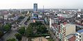 Downtown Yangon, facing Sule Pagoda and Hlaing River
 -
 Downtown Yangon by night
 -
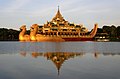 Karaweik Palace on Kandawgyi Lake
 -
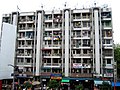 Downtown flats
 -
The High Court as seen from Mahabandoola Garden
-
 Shwedagon Pagoda, a landmark of Yangon
 -
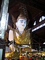 Ngahtatgyi Buddha image
 -
Downtown Yangon In The Evening
-
Central Yangon
-
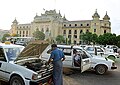 Taxi at Yangon City Hall
 -
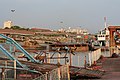 Yangon River Jetty


References
- The Popular Encyclopedia or Conversation Lexicon. Blackie & Son, 1890.
Notes
- ^ "Burma's new capital stages parade". BBC News. 2006-03-27. Retrieved 2006-08-03.
- ^ Martin, Steve (2004-03-30). "Burma maintains bygone buildings". BBC News. Retrieved 2006-05-22.
- ^ "Special Report". Myanmar Times. Retrieved 2006-08-13.
- ^ Falconer, John; et al. (2001). Burmese Design & Architecture. ISBN 9-6259-3882-6.
{{cite book}}: Explicit use of et al. in:|first=(help) - ^ http://www.boston.com/news/world/asia/articles/2006/01/01/abrupt_relocation_of_burma_capital_linked_to_astrology/
- ^ a b "Rangoon Residents Told to Show Photos". The Irrawaddy. 2006-06-05. Retrieved 2006-08-31.
- ^ "Lawyer Aye Myint warns oppression could lead to implosion in Burma". Democratic Voice of Burma. 2006-08-24. Retrieved 2006-08-31.
- ^ "Yangon". Asian Network of Major Cities 21. Retrieved 2006-08-13.
- ^ Parker, Clive (May 2006). "Rangoon Bets on Business". The Irrawaddy. Retrieved 2006-05-22.
External links
- Yangon Travel Guide by Wikitravel
- Yangon Impressions - Mashup of up-to-date photos, events, hotel information, maps and articles on Rangoon and Shwedagon (German/English)
- Satellite picture by Google Maps
- Yangon City Hall website
- BBC article about British colonial architecture in Yangon
- YCDC website
- Rangoon Photo Gallery