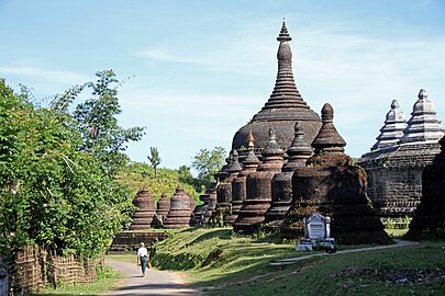
Arakan
Arakan | |
|---|---|
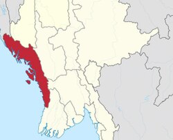 Arakan lies on the west coast of Burma facing the Bay of Bengal | |
| Status | Waithali Kingdom (8th century-10th century) Lemro Period (11th century) Vassal state of Bengal (15th century) Mrauk U Kingdom (15th century-18th century) Part of the Sur dynasty (16th century) Part of the Third Burmese Empire (18th century) Division of British Burma (19th century) Province of Myanmar (1948–present) |
| Capital | Dhanyawadi Waithali Pyinsa Parein Nareinzara Toungoo Launggyet (1251–1429 Mrauk-U (1430–1785) Sittwe (19th century-present) |
| Common languages | Arakanese, Burmese, Bengali |
| Religion | Buddhism |
Arakan (/ˈærəkæn/ or /ˈɑːrəkɑːn/[1]) is the historical geographical name of Rakhine State, Myanmar (formerly Burma). The region was called Arakan for centuries until the Burmese military junta changed its name in 1989. The people of the region were known as Arakanese.[2][3][4]
Arakan's first states can be traced to the 4th century. Arakan was one of the first Indianized kingdoms in Southeast Asia. It was home to the sacred Mahamuni sculpture of Buddha, which was later transferred to Mandalay by Burmese conquerors in the 18th century. For 356 years between 1428 and 1784, Arakan was ruled by the Kingdom of Mrauk U from the city of Mrauk U. The kingdom was founded as a vassal state of the Bengal Sultanate. It later asserted its independence and adopted the customs of the Bengal Sultanate, including Muslim titles for its kings. All of the Kingdoms of Arakan were ruled by Buddhist kings; therefore, Buddhism was considered the state religion. Minorities including Muslims and Hindus were also present in the region. It was also home to Hindus and Christians. The Portuguese were active in the region.[3]
Arakan Division was a part of British India and later fell under British rule in Burma. Arakan was a major rice exporter in the world during the 19th and early 20th centuries. During World War II, several Arakan Campaigns were conducted by Allied forces against the Japanese as part of the Burma Campaign. After Burma became independent in 1948, Arakan saw a movement for autonomy. Human rights deteriorated in the country after the 1962 Burmese coup d'état. In 1974, a discriminatory citizenship law was enacted. In 1982, most Arakanese Muslims were stripped of citizenship. A segregated system of citizenship was introduced by Burma's military rulers. Both Arakanese Buddhists and Muslims experienced growing nationalism, including hopes for self-rule. After Burma's controversial citizenship law in 1974, the Buddhists became known as Rakhines and Muslims became known as Rohingya. The region was the site of the Rohingya genocide in 2016 and 2017.
Etymology
[edit]According to Arthur Purves Phayre, a report by the Royal Geographical Society in November 1882 included a paper by one Colonel Yule who discussed the oldest records of a sea route to China from the Middle East. Yule identified Arakan with the country of "Argyre" which means The Land of Silver or Silverland mentioned by the Greco-Roman geographer Claudius Ptolemy.[5]

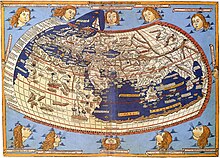
Portuguese records spelled the name as Arracao.[6] The name was spelled as Araccan in many old European maps and publications.[7] The area constituted Arakan Division under British rule in Burma.[8] The name “Arakan” was in use until 1989 when the military government of Burma changed the name to Rakhine State.[9]
Geography
[edit]
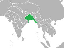
Arakan is a coastal geographic region in Lower Burma. It comprises a long narrow strip of land along the eastern seaboard of the Bay of Bengal and stretches from the Naf River estuary on the border of the Chittagong Hills area (in Bangladesh) in the north to the Gwa River in the south. The Arakan region is about 400 miles (640 km) long from north to south and is about 90 miles (145 km) wide at its broadest. The Arakan Mountains (also called Arakan Yoma), a range that forms the eastern boundary of the region, isolates Arakan from the rest of Burma. The coast has several sizable offshore islands, including Cheduba and Ramree.
The region's principal rivers are the Nāf estuary and the Mayu, Kaladan, and Lemro rivers. One-tenth of Arakan's generally hilly land is cultivated. Rice is the dominant crop in the delta areas, where most of the population is concentrated. Other crops include fruits, chilies, dha and tobacco.[10]
The main towns are coastal and include Sittwe (Akyab), Sandoway, Kyaukpyu and Taungup.[10]
History
[edit]Antiquity
[edit]
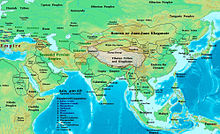

Arakan has been recognized “as one among other Burmese kingdoms competing for the control of power in Lower Burma”.[11] The cities of Bago, Bagan and Inwa were the centres of political power in Burma proper. In contrast, independent Arakanese states were based in the capital cities of Dhanyawadi, Vesali, Laungyet and Mrauk-U. The ruins of these cities are located in northern Arakan in proximity to the borderland of Bengal.
It is unclear who the earliest inhabitants were; some historians believe the earliest settlers included the Burmese Mro tribe but there is a lack of evidence and no clear tradition of their origin or written records of their history.[12] Arakanese traditional history holds that Arakan was inhabited by the Rakhine since 3000 BCE, but there is no archaeological evidence to support the claim.[13]: 17 According to British historian Daniel George Edward Hall, who wrote extensively on the history of Burma, "The Burmese do not seem to have settled in Arakan until possibly as late as the tenth century AD. Hence earlier dynasties are thought to have been Indian, ruling over a population similar to that of Bengal. All the capitals known to history have been in the north near modern Akyab".[14]
Arakan came under strong Indic influence from the Indian subcontinent, particularly the ancient kingdoms of the Ganges delta. Arakan was one of the first regions in Southeast Asia to adopt Dharmic religions. It became one of the earliest Indianized kingdoms in Southeast Asia. Buddhist missionaries from the Mauryan Empire traveled through Arakan to other parts of Southeast Asia.[15][16] Paul Wheatley chronicled the "Indianization" of Arakan.[17]
According to Pamela Gutman, "Arakan was ruled by kings who adopted Indian titles and traditions to suit their own environment. Indian Brahmins conducted royal ceremonies, Buddhist monks spread their teachings, traders came and went and artists and architects used Indian models for inspiration. In the later period, there was also influence from the Islamic courts of Bengal and Delhi".[18] Gutman writes that “the maintenance of a state appropriate to kingship required the ministrations of increasing numbers of craftsmen and artisans, the most skilled of whom were often accommodated within the royal compound. It required the labour of a peasantry who contributed the surplus produce of their fields as a kind of tax in kind for the support of the court, and a band of armed retainers who acted as household guards, organised the peasantry as militia and enforced the authority of the ruler. Material defences – walls and moats protecting the palace and the city – were constructed and the city-state, the nagara, evolved. These transformations saw the tribal chieftain replaced by a divine king, shaman by brahmin priest, tribesman as cultivators by peasants, tribesmen as warriors by an army, and favoured the development of occupational specialisation. They were reflected in the conversion of the chief’s hut into a palace, the spirit house into a temple, the object of the spirit cult into the palladium of the state, and the boundary spirits which previously had protected the village into Indianized Lokapalas presiding over cardinal directions. This process can clearly be traced in Arakan, which received Indian culture by land from Bengal and by sea from other parts of India”.[18]
First states and cities
[edit]
Due to the evidence of Sanskrit inscriptions found in the region, historians believe the founders of the first Arakanese state were Indian.[13]: 17 The first Arakanese state flourished in Dhanyawadi between the 4th and 6th centuries. The city was the center of a large trade network linked to India, China and Persia.[13]: 18 Power then shifted to the city of Waithali, where the Candra dynasty ruled. Waithali became a wealthy trading port.[13]: 18 The Candra-ruled Harikela state was known as the Kingdom of Ruhmi to the Arabs.[19] Evidence points to the use of the ancient Bengali script in Arakan.[20] The Anandacandra inscription recorded the reign of the Candra dynasty.[21]
Since in the 8th century, Arab merchants began conducting missionary activities in southeast Asia.[22] Some researchers have speculated that Muslims used trade routes in the region to travel to India and China.[23] A southern branch of the Silk Road connected India, Burma and China since the neolithic period.[24][25] It is unclear whether the Rakhine people were one of the tribes of the Burmese Pyu city-states because the people in those states at the time spoke a Tibeto-Burman language while Arakan (Rakhine) speakers are from the Sino-Tibetan language family. They began migrating to Arakan through the Arakan Mountains in the 9th century. The Rakhines settled in the valley of the Lemro River. Their cities included Sambawak I, Pyinsa, Parein, Hkrit, Sambawak II, Myohaung, Toungoo and Launggret.[13]: 18–20
Kingdom of Mrauk U
[edit]
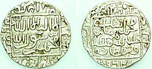
Arakan was a kingdom under siege in the 14th and 15th centuries. Mon invaders from Lower Burma conquered southern Arakan, including Sandoway. In 1404, Burmese forces from Upper Burma conquered Laungyet. The ruler of Laungyet fled to the Bengal Sultanate during the Burmese invasion. According to Jacques Leider, Min Saw Mun fled to Bengal in 1406 and returned to Arakan in 1428. Min Saw Mun arrived in Bengal for self-imposed exile during the reign of Sultan Ghiyasuddin Azam Shah (1389–1410) and left for Arakan during the reign of Sultan Jalaluddin Muhammad Shah (1415–1432).[26] An academic consensus prevails that Min Saw Mun returned to Arakan, regained the throne and shifted the capital from Laungyet to Mrauk-U (erstwhile Mrohaung). The establishment of the capital at Mrauk-U heralded the most significant period in the history of Arakan. A new cosmopolitan kingdom emerged. In Arakanese traditional history, the restoration of the throne is glorified.
Bengali literary texts and coinage are among the chief primary sources to detail the history of Arakan during the Mrauk-U period. Min Saw Mun regained control of the throne with military assistance from the Bengal Sultanate. Arakan emerged as a vassal state of Bengal.[27] Burhanuddin became the first Muslim defense minister of Arakan.
Evidence points to an alliance between Bengal and Arakan to restore Min Saw Mun to the throne. The most significant evidence is that all post-restoration Arakanese rulers adopted Muslim titles in addition to native titles. This indicates a relationship with the Islamic court of Bengal. Restoring the throne of a neighbouring kingdom was not unprecedented for Bengal. The throne of Tripura was also restored by the Bengal Sultanate. Arakanese traditional history states that Arakan was a tributary state of the Bengal Sultanate for a certain period.[27]
The kings of Arakan adopted both Buddhist and Muslim titles after the restoration. In the accounts of foreign travelers like Fray Sebastian Manrique and Bengali members of the Arakanese court, the kings are referred with their Muslim titles. But the kings did not convert to Islam and remained Buddhists. It appears that Arakan’s kings were following ancient footsteps by imitating royal customs from the subcontinent. Arakan not only integrated Hindu-Buddhist rituals from the subcontinent; but it also integrated the influence of Islamic India, particularly the Bengal Sultanate. Between 1430 and 1638, a total of 16 kings are recorded to have used Muslim titles.[28]
In conclusion, the Arakan State has always been predominantly Buddhist, with the majority known today as the Rakhine people. Although all the kings of Arakan had Muslim titles, none of them adopted the religion; they remained as Buddhists.
-
King Min Hti of Arakan
-
Maha Thammada, the last king of Arakan
-
Anawrahta, king of Launggyet Arakan
-
King Min Bin Statue

| Native name | Muslim title | Reign | |
|---|---|---|---|
| 1. | Min Saw Mon | Suleiman Shah | 1430–1434 |
| 2. | Min Khari | Ali Shah I | 1434–1459 |
| 3. | Basawpyu | Kalima Shah | 1459–1482 |
| 4. | Min Dawlya | Maw Ku Shah | 1482–1492 |
| 5. | Basawnyo | Muhammad Shah | 1492–1494 |
| 6. | Ranaung | Nuri Shah | 1494 |
| 7. | Salingatha | Sheikh Abdullah Shah | 1494–1501 |
| 8. | Min Raza | Ilyas Shah | 1501–1513 |
| 9. | Min Saw O | Zala Shah | 1515 |
| 10. | Thazata | Ali Shah II | 1515–1521 |
| 11. | Kasabadi | Jali Shah | 1523–1525 |
| 12. | Min Bin | Zabauk Shah | 1531–1553 |
| 13. | Min Palaung | Sikandar Shah I | 1571–1593 |
| 14. | Min Raza Gyi | Salim Shah | 1593–1612 |
| 15. | Min Khamaung | Hussain Shah | 1612–1622 |
| 16. | Thiri Thudamma Raja | Sikandar Shah II | 1622–1638 |

Arakan became home to a growing Muslim community. They included Muslim traders from the Indian Ocean trade network and Sufi missionaries who established themselves along the coasts of Arakan. More Muslims were found among the thousands of inhabitants of Bengal who were forcibly deported to Arakan. They included artists, craftsmen, soldiers, and highly educated people who were employed by the royal court.[29] The slave trade was the backbone of the Arakanese economy. Leider explains that “Arakan was sadly famed as the main provider of slaves in the Bay of Bengal” unlike Bengal's trade in muslin, silk, shipbuilding, and saltpeter.[30]
The kings imported labour, bureaucrats and artisans by raiding Lower Burma and southeast Bengal. They provided the craftsmen, guards, and artists at the palace; the rowers for the fleet, or the farmers on the royal lands. Some became ministers in the royal court. The heavy presence of Bengali Muslims was documented by Arakanese and European records. The Mons were deported after the fall of Pegu; they formed a group which could still be identified until the end of the eighteenth century. Afghan soldiers fleeing the Mughal advance and Portuguese traders and adventurers settled in Arakan. They accepted appointments in the army. The hill chiefs of northern and southern Arakan provided troops who were ethnic Thet, Mrung, Chin, or from other small minority groups. The elite were ethnically and culturally diverse.[31]
Min Khayi (Ali Khan) was the first to challenge Bengali hegemony. Ba Saw Phyu (Kalima Shah) defeated Bengal Sultan Rukunuddin Barbak Shah in 1459. Min Bin (Zabuk Shah) conquered Chittagong. Taking advantage of the Mughal Empire's invasion campaign of Bengal, the Arakan navy and pirates dominated a coastline of 1000 miles, spanning from the Sundarbans to Moulmein. The kingdom's coastline was frequented by Arab, Dutch, Danish and Portuguese traders. Control of the Kaladan River and Lemro River valleys led to increased international trade, making Mrauk U prosperous. The reigns of Min Phalaung (Sikender Shah), Min Rajagiri (Salim Shah I) and grandson Min Khamaung (Hussein Shah) strengthened the wealth and power of Mrauk U.[13]: 20–21 Arakan colluded in the slave trade with the Portuguese settlement in Chittagong. After conquering the port city of Syriam in the early 1600s, Arakan appointed the Portuguese mercenary Philip De Brito e Nicota as the governor of Syriam. But Nicota later transferred Syriam to the authority of Portuguese India.[13]: 21 Even after independence from the Sultans of Bengal, the Arakanese kings continued the custom of maintaining Muslim titles.[32] They compared themselves to Sultans and fashioned themselves after Mughal rulers. They also continued to employ Indians and Muslims in prestigious positions within the royal administration.[33] The court adopted Indian and Islamic fashions from neighbouring Bengal.[33][34] Mrauk U hosted mosques, temples, shrines, seminaries and libraries.[13]: 22 Syed Alaol and Daulat Qazi were prominent poets of Arakan.[35] The Santikan Mosque was built in Mrauk U.[36] Indian and Muslim influence continued on Arakanese affairs for 350 years.

In 1660, Shah Shuja, the brother of Emperor Aurangzeb and a claimant of the Peacock Throne, received asylum in Mrauk U. Members of Shuja's entourage were recruited in the Arakanese army and court. They were kingmakers in Arakan until the Burmese conquest.[37] Arakan suffered a major defeat to the forces of Mughal Bengal during the Battle of Chittagong in 1666, when Mrauk U lost control of southeast Bengal. The Mrauk U dynasty's reign continued until the 18th century.
- Ruins of Mrauk U
-
Skyline of Mrauk U
-
Koe-Thaung Gateway
-
Ratanabon
-
Pagodas in Mrauk U
Burmese conquest
[edit]The Konbaung Dynasty conquered Arakan in 1784. Mrauk U was devastated during the invasion.[13]: 22 The Burmese Empire executed thousands of men and deported a considerable portion of people from the Arakanese population to central Burma.[38] The independence of Arakan ended in 1784 when Burmese forces conquered Mrauk-U. The Arakanese royal court was deported to central Burma. The religious relics of the kingdom, including the sacred Mahamuni sculpture of Buddha, were seized and transferred to Amarapura in Mandalay.
Rakhine rebellions were suppressed. Many Rakhine Buddhists fled by sea to the Barisal region of Bengal, where their descendants continue to live today.[39] It is also likely that Arakanese Muslims became dispersed across Burma and Bengal as either deportees or refugees due to the conflict. Arakan experienced a demographic vacuum as a result of the Burmese conquest. There were several uprisings against Burmese rule, including a rebellion by Chin Bya in 1811.[40] The uprisings caused recurrent Burmese raids into British India, which led to the First Anglo-Burmese War.
British Empire
[edit]


The Burmese Empire ceded Arakan to the British East India Company in the 1826 Treaty of Yandabo. Arakan became one of the divisions of British India. Initially governed as part of the Bengal Presidency, it received many settlers from neighboring Chittagong Division. The settlers became influential in commerce, agriculture and shipping.

During British rule, Arakan Division was one of the largest rice exporters in the world.[41] Arakan was the pioneer of the rice industry in British Burma. The emergence of Burma as a global rice exporter in the 20th century can be traced to Arakan. As one of the earliest regions to be conquered by the British, Arakan saw the removal of export restrictions imposed by the Burmese Empire. Rice was exproted to Bengal and beyond.[42] Akyab (now Sittwe), the divisional capital of Arakan, was located in proximity to the Chittagong Division of British Bengal. In 1840, Akyab exported 74,500 tons of rice valued at an estimated 1.2 million rupees. In 1855, Akyab exported 162,000 tons of rice valued at an estimated 3 million rupees. The growth in rice exports was driven by the expansion of farmland – by clearing out jungles and cultivating paddy fields.

| Period | In Thousands of Tons |
|---|---|
| 1865 to 1870 | 308 |
| 1871 to 1875 | 484 |
| 1876 to 1880 | 557 |
| 1881 to 1885 | 707 |
| 1886 to 1890 | 657 |
Agriculturalists from Chittagong played an important role in the development of the rice economy in Arakan. When the British took control of Arakan, the borderland with Bengal was filled with dense vegetation. British objectives in Arakan centred on stimulating the rice economy. Transforming forests and barren land into paddy fields offered the potential of generating revenue by taxing rice farmers. The colonial economy in South and Southeast Asia depended on the taxation of farmers. Arakan neighboured the densely populated province of Bengal where demand for rice was high. Rice was a staple food of Bengal and demand for rice surged during periods of food shortages and famine. Arakan met this demand and profited from the rice trade. Akyab had shipping links with the ports of Bengal, including Calcutta, Chittagong, Narayanganj, Goalundo and Dacca. By the 20th century, Akyab enjoyed shipping links with Europe, Malaya, China, Ceylon and the Dutch East Indies. Arakanese rice was being exported to many parts of the world. The American Civil War disrupted the rice supply chain from the southern states of the United States of America. European traders and millers looked for an alternative location for rice imports. British Burma, with its expanding and low cost rice production, provided a lucrative alternative to the United States. The arrival of leading European banking and shipping companies in Burma propelled the rice trade into the single most important cash crop sector of the Burmese economy. In 1864, Liverpool imported an estimated 1000 tons of rice from Burma.[44] The opening of the Suez Canal lowered the cost of shipping from Burma. European firms began to set up rice mills in Burma itself. Indian and Chinese merchants proliferated Burma’s ports. The rice economy supported the development of infrastructure, public services and other sectors of commerce. Rice from Lower Burma and Arakan became the backbone of the Burmese economy.
In 1869, Muslims constituted 12.24% of the population in Arakan. In 1931, they constituted 25.56%. In the divisional capital Akyab, the share of the Muslim population increased from 20.67% in 1869 to 38.41% in 1931. The British administration considered Chittagonian migration from Bengal as a key factor in the growth of the Muslim population. The colonial government encouraged Chittagonian migration as part of its policy to expand the rice economy in Arakan. The northern part of Arakan received the largest influx of settlers. The township of Naaf (now Maungdaw), which bordered Chittagong Division, became an extension of farmlands in Cox’s Bazar. The Naaf economy was essentially integrated with the greater Chittagong economy. Between the 1870s and 1880s, the Naaf experienced a surge in population growth due to immigration. Settlers included not only Muslims and Hindus from Chittagong; but also returning Buddhist refugees who were displaced by earlier wars. Muslims formed the overwhelming majority of settlers. This was complemented by the transformation of waste lands into rice fields. Settlers constituted 70% of Naaf’s population, owned 79% of cultivated land and held 84% of tax-paying landed property.[45] Colonial census reports in 1921 and 1931 described Arakanese Muslims with various terms, including “Arakan Mahomedans”, “Chittagonian Mahomedans born in Burma”, “Chittagonian Mahomedans born outside of Burma”, “Bengali Mahomedans born in Burma”, “Bengali Mahomedans born outside of Burma”, “Indian Muslims” and “Indo-Burmans”.[2] In 1937, Arakan became part of Burma Province, which was separated from India into a distinct crown colony.
World War II
[edit]
During World War II, Arakan endured the Japanese occupation of Burma. The Burma National Army and the pro-British V Force were active in the region. Sectarian tensions flared during the Arakan massacres in 1942. Japanese rule ended with the successful Burma Campaign by Allied forces.
The division's seaport and capital Akyab were dominated by Arakanese Indians who were aligned with the British, which caused tension with Arakanese Burmese, many of whom were aligned with the Japanese.[46] Both groups were represented as natives in the Legislative Council of Burma and the Legislature of Burma. In the 1940s, Arakanese Muslims appealed to Muhammad Ali Jinnah to incorporate the townships of the Mayu River valley into the Dominion of Pakistan.[47]
Burmese independence
[edit]Arakan became one of the Union of Burma's divisions after independence from British rule. Burma was a parliamentary democracy until the 1962 Burmese coup d'état. The northern part of Arakan was governed by the central government in Rangoon in the early 1960s. Known as the Mayu Frontier District, it covered townships near the border with East Pakistan.
In 1982, the Burmese junta enacted the Burmese nationality law which did not recognize Arakanese Indians as one of Burma's ethnic groups, thereby stripping them of their citizenship. In 1989, the Burmese government altered the country's name from Burma to Myanmar. In the 1990s, the State Peace and Development Council changed the name of Arakan State to Rakhine State. The province was renamed after the Rakhine ethnic group. However, the new name is not accepted as legitimate by many in both the Rakhine and Rohingya communities, instead preferring the historical term Arakan.
Rakhine-led groups like the Arakan Liberation Army have sought independence for the region. Other groups, including the Arakan Rohingya National Organization, have demanded autonomy. The region witnessed military crackdowns during Operation King Dragon in 1978; in 1991 and 1992 after the 8888 uprising and 1990 Burmese general election; the 2012 Rakhine State riots, the 2015 Rohingya refugee crisis and Rohingya persecution in Myanmar (2016-present).
Demographics
[edit]The people of Arakan have historically been called the Arakanese.[2] The population consists of Tibeto-Burmans and Indo-Aryans. Tibeto-Burman Arakanese mostly speak the Arakanese language, also known as Rakhine and closely related to Burmese. Most Indo-Aryan Arakanese speak the Rohingya language. Other languages spoken by smaller communities in Rakhine state include the Tibeto-Burman Chak, Asho Chin, Ekai, Kumi, Laitu, Mru, Songlai, Sumtu, Uppu and Chakma.[48]
The government of Myanmar recognizes Tibeto-Burman Arakanese as the Rakhine people. It also recognizes sections of the Muslim community, including the Kamein.[citation needed] But Myanmar does not recognize the Rohingya.
Arakan Division had the largest percentage of Indians in British Burma.[49]
See also
[edit]References
[edit]- ^ Columbia Encyclopedia, s.v. "Rakhine State".
- ^ a b c "The long history of the Rohingyas that Myanmar refuses to acknowledge". 29 September 2021.
- ^ a b "Arakanese | Definition, Location, & Ancient Kingdom | Britannica".
- ^ Sheikh, Nur-Mohammad (19 March 2023). "The return of the Arakanese Muslims: Could this be the beginning of a resolution to the Rohingya crisis?". Dhaka Tribune. Archived from the original on 13 Feb 2024. Retrieved 13 Feb 2024.
- ^ Lieut.-General Sir Arthur P. Phayre G.C.M.G, K.C.S.I., AND C.B., ‘Chapter V: Arakan’, History of Burma including Burma Proper, Pegu, Taungu, Tenasserim, and Arakan: From the Earliest Time to the End of the First War with British India (2nd edn, 1967). 42
- ^ Frederick Charles Danvers (1988). The Portuguese in India: Being a History of the Rise and Decline of Their Eastern Empire. Asian Educational Services. p. 528. ISBN 978-81-206-0391-2.
- ^ Thomas Bankes; Edward Warren Blake; Alexander Cook; Thomas Lloyd (1800). A New, Royal, and Authentic System of Universal Geography, Ancient and Modern: Including All the Late Important Discoveries ... and a Genuine History and Description of the Whole World ... Together with a Complete History of Every Empire, Kingdom, and State ... to which is Added a Complete Guide to Geography, Astronomy, the Use of the Globes, Maps ... p. 247.
- ^ Cheng Siok-Hwa (2012). The Rice Industry of Burma, 1852–1940: (First Reprint 2012). Institute of Southeast Asian Studies. p. 86. ISBN 978-981-230-439-1.
- ^ Jacques Leider, Territorial Dispossession and Persecution in North Arakan (Rakhine), 1942–43 (2020) <https://www.toaep.org/pbs-pdf/101-leider/> accessed 5 August 2021.
- ^ a b The Editors (1959-08-21). "Arakan | state, Myanmar". Britannica.com. Retrieved 2017-09-18.
{{cite web}}:|author=has generic name (help) - ^ Jacques Leider, 'Arakan's Ascent During The Mrauk U Period', Recalling Local Pasts: Autonomous History in Southeast Asia (Silkworm Books 2002). 58
- ^ Beniison, J.J (1933). Census of India, 1931: Burma Part I – Report. Rangoon: Office of Superintendent, Government Printing and Stationery, Burma. p. 149.
- ^ a b c d e f g h i William J. Topich; Keith A. Leitich (9 January 2013). The History of Myanmar. ABC-CLIO. ISBN 978-0-313-35725-1.
- ^ D. G. E Hall, A History of South East Asia, New York, 1968, P. 389.
- ^ British Academy (4 December 2003). Proceedings of the British Academy, Volume 121, 2002 Lectures. OUP/British Academy. p. 76. ISBN 978-0-19-726303-7.
- ^ Singer, Noel F. (1980-11-24). Vaishali and the Indianization of Arakan - Noel F. Singer - Google Books. APH. ISBN 9788131304051. Retrieved 2017-09-17.
- ^ Pamela Gutman and Zaw Min Yu, Burma's Lost Kingdoms: Splendours of Arakan (Orchid Press 2001). 3
- ^ a b Pamela Gutman and Zaw Min Yu, Burma's Lost Kingdoms: Splendours of Arakan (Orchid Press 2001). p. 8
- ^ "Harikela – Banglapedia". En.banglapedia.org. 2014-05-05. Retrieved 2017-09-17.
- ^ “Three medallions above the head contain sacred syllables in proto-Bengali script”. Pamela Gutman and Zaw Min Yu, ‘Vesali’, Burma's Lost Kingdoms: Splendours of Arakan (Orchid Press 2001). p. 57
- ^ Pamela Gutman and Zaw Min Yu, Burma's Lost Kingdoms: Splendours of Arakan (Orchid Press 2001). p. 3
- ^ Sunil S. Amrith (7 October 2013). Crossing the Bay of Bengal. Harvard University Press. p. 37. ISBN 978-0-674-72846-2.
- ^ "The thoroughfare of Islam – Dhaka Tribune". www.dhakatribune.com.
- ^ Foster Stockwell (30 December 2002). Westerners in China: A History of Exploration and Trade, Ancient Times through the Present. McFarland. p. 15. ISBN 978-0-7864-8189-7.
- ^ Fuxi Gan (2009). Ancient Glass Research Along the Silk Road. World Scientific. p. 70. ISBN 978-981-283-357-0.
- ^ Jacques Leider, 'Arakan's Ascent During The Mrauk U Period', Recalling Local Pasts: Autonomous History in Southeast Asia (Silkworm Books 2002). 63
- ^ a b In the Arakanese tradition, we find that “The restored king agreed to be tributary to the king of Bengal”.” Mohammad Ali Chowdhury, ‘Bengal-Arakan Relations at the turn of the 15th century’, Bengal-Arakan Relations (1430–1666 A.D.) (1st edn, 2004). 32
- ^ a b Bengal-Arakan Relations (1430–1666 A.D.) by Mohammed Ali Chowdhury
- ^ Jacques Leider, 'Arakan's Ascent During The Mrauk U Period', Recalling Local Pasts: Autonomous History in Southeast Asia (Silkworm Books 2002). 55
- ^ Jacques Leider, 'Arakan's Ascent During The Mrauk U Period', Recalling Local Pasts: Autonomous History in Southeast Asia (Silkworm Books 2002). 79
- ^ Jacques Leider, 'Arakan's Ascent During The Mrauk U Period', Recalling Local Pasts: Autonomous History in Southeast Asia (Silkworm Books 2002). 81
- ^ Yegar 2002, pp. 23–24.
- ^ a b Yegar 2002, p. 24.
- ^ Aye Chan 2005, p. 398.
- ^ Francesca Orsini; Katherine Butler Schofield (5 October 2015). Tellings and Texts: Music, Literature and Performance in North India. Open Book Publishers. p. 424. ISBN 978-1-78374-102-1.
- ^ "The Hidden City of Myanmar".
- ^ Mohamed Nawab Mohamed Osman (19 June 2017). Islam and Peacebuilding in the Asia-Pacific. World Scientific. p. 24. ISBN 978-981-4749-83-1.
- ^ Aye Chan 2005, p. 399.
- ^ "Rakhain, the – Banglapedia".
- ^ "Burma/Bangladesh: Burmese Refugees in Bangladesh – Historical Background".
- ^ Georg Hartwig (1863). The Tropical World: a Popular Scientific Account of the Natural History of the Animal and Vegetable Kingdoms in the Equatorial Regions. Longman, Green, Longman, Roberts, and Green. p. 159.
- ^ Cheng Siok Hwa, 'The Development of the Burmese Rice Industry in the Late Nineteenth Century' (1965) 6 Journal of Southeast Asian History. 69
- ^ Cheng Siok Hwa, 'The Development of the Burmese Rice Industry in the Late Nineteenth Century' (1965) 6 Journal of Southeast Asian History.
- ^ Cheng Siok Hwa, 'The Development of the Burmese Rice Industry in the Late Nineteenth Century' (1965) 6 Journal of Southeast Asian History. 74–75
- ^ Jacques Leider, 'The Chittagonians In Colonial Arakan: Seasonal And Settlement Migrations', Colonial Wrongs and Access to International Law (Torkel Opsahl Academic EPublisher 2020).
- ^ Christopher Alan Bayly; Timothy Norman Harper (2005). Forgotten Armies: The Fall of British Asia, 1941–1945. Harvard University Press. p. 91. ISBN 978-0-674-01748-1.
- ^ Yegar 1972, p. 10.
- ^ Eberhard, David M.; Simons, Gary F.; Fennig, Charles D., eds. (2019). "Myanmar – Languages". Ethnologue. SIL International.
- ^ Robert H. Taylor (1987). The State in Burma. C. Hurst & Co. Publishers. pp. 126–127. ISBN 978-1-85065-028-7.
Sources
[edit]- Aye Chan (Autumn 2005). "The Development of a Muslim Enclave in Arakan (Rakhine) State of Burma (Myanmar)" (PDF). SOAS Bulletin of Burma Research. 3 (2). Archived from the original (PDF) on 12 July 2013. Retrieved 11 September 2017.
- Yegar, Moshe (1972). Muslims of Burma (PDF). Wiesbaden: Verlag Otto Harrassowitz.
- Yegar, Moshe (2002). Between integration and secession: The Muslim communities of the Southern Philippines, Southern Thailand, and Western Burma / Myanmar. Lanham, MD: Lexington Books. ISBN 978-0-7391-0356-2.
External links
[edit] Media related to Arakan at Wikimedia Commons


