Beatrice, Mississippi
Appearance
Beatrice, Mississippi | |
|---|---|
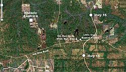
 Aerial view of Beatrice community | |
| Country | United States |
| State | Mississippi |
| County | Stone |
| Elevation | 164 ft (50 m) |
| Time zone | UTC-6 (Central (CST)) |
| • Summer (DST) | UTC-5 (CDT) |
| Area code | Area code 601 |
| GNIS feature ID | 692497[1] |
Beatrice is an unincorporated community in Stone County, Mississippi, and is located approximately 23 miles (37 km) southeast of Wiggins. Beatrice is part of the Gulfport-Biloxi metropolitan area. The main period of significance was between 1894 and 1915.[2]
Surrounded by the De Soto National Forest, Beatrice has long been a timber and sawmill community. In the wake of Hurricane Katrina, the Beatrice Sawmill served as a distribution center for portable sawmills that were needed to convert storm-ravaged trees into lumber.[3]
Little Creek Baptist Church and headquarters for Red Creek Wildlife Management Area are located in the Beatrice community.
Education
- The Beatrice community is served by the Stone County School District.
Transportation
- The Beatrice community is served by Mississippi Highway 15.
References
- ^ GNIS (Beatrice, Mississippi) Retrieved 2014-01-01
- ^ Mississippi History and Genealogy Place Names Retrieved 2014-01-01
- ^ Wood-Mizer Mississippi, TimberLine Magazine (September 1, 2006) Retrieved 2014-01-01

