Stara Zagora
Stara Zagora
Стара Загора | |
|---|---|
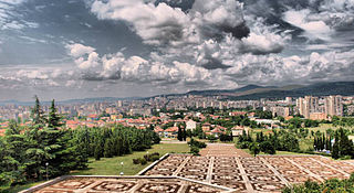
 Stara Zagora from the Samarsko Zname Monument | |
|
| |
| Nickname: The city of the linden-trees | |
| Country | |
| Province | Stara Zagora |
| Government | |
| • Mayor | Svetlin Tanchev |
| Area | |
| • City | 85,786 km2 (33,122 sq mi) |
| Elevation | 196 m (643 ft) |
| Population (Census February 2011)[1] | |
| • City | 136,363 |
| • Density | 1,590/km2 (4,100/sq mi) |
| • Urban | 157,831 |
| Time zone | UTC+2 (EET) |
| • Summer (DST) | UTC+3 (EEST) |
| Postal Code | 6000 |
| Area code | 042 |
| Website | www.starazagora.bg |
Stara Zagora (Bulgarian: Стара Загора) is the sixth largest city in Bulgaria, and a nationally important economic center. Located in Southern Bulgaria, it is the administrative capital of the homonymous Stara Zagora Province. As of February 2011, the city has a population of 136,363 inhabitants.[1] According to Operative Program Regional Development of Bulgaria the agglomeration of Stara Zagora is the fifth largest in Bulgaria and has a population of 213,444 inhabtans [1](page 39).
Stara Zagora is known as the city of straight streets, linden trees, and poets.
History


The city of Stara Zagora is one of the oldest cities in Europe with an eight thousand-year history. The favourable geographic and climatic conditions of the territory around Stara Zagora contributed to the establishment of several prehistoric settlements in the remote past. More than 100 prehistoric mounds from the 6th to 3rd millennium BC were found in the vicinity of Stara Zagora. One of them, the Bereketska mound, is the largest in Bulgaria, containing traces of people that lived there from the New Stone Age (6th millennium BC) to the Middle Ages (12th century). A prehistoric settlement can be found within the city itself. Two dwellings from the New Stone Age are preserved in the Neolithic Dwellings Museum. These are the best preserved dwellings from the New Stone or Neolithic Age (6th millennium BC) in Europe and contain a rich collection of tools and artefacts. The oldest copper mines in Europe (5th millennium BC) were found 8 km (4.97 mi) east of the city, A considerable amount of copper ore was extracted from the 11 mines by the ancient inhabitants of this land who traded with it throughout the continent.
The city of Stara Zagora is one of the oldest cities in Europe. Located at the cross-roads of multiple civilizations, Stara Zagora is an important piece in the European cultural routes mosaic. Inhabited by Thracians, ancient Greeks, Romans, Ottomans and Bulgarians, this unique city bears the historical imprint of those past civilizations along with many of their historical treasures. Proof of its longevity can be found in the multiples names of the city, each one connected with a different era of its development.
Augusta Traiana
Founded around 106 AD by the Emperor Marcus Ulpius Traianus (98-117 AD), Augusta Traiana, "the most flamboyant city of the Traians" was the second largest city in the Roman province of Thrace during 2nd - 3rd c. AD, after Philipopolis. It occupied an area of 38 hectares and was fortified by strong fortress walls.
Augusta Traiana had the statute of an autonomous city of the ‘polis' type (i.e. city-state). From the time of Emperor Marcus Aurelius (161-180 AD) to the Emperor Galienus (253-268 AD) it had the right to mint its own bronze coins, which were in circulation all over the Balkan Peninsula.
Beroe
Between 4th and 7th centuries the city had the name of Beroe. It was a religious centre of the early Christians on these lands and the residence of an archbischop.
Irinopolis
For a short period it was named after the Byzantine Empress Irina who visited the city in 784 AD.
Vereya
In 812 AD the city became part of the First Bulgarian State under the name of Vereya or also found as Bereya, Beroya.
Boruy
During the Second Bulgarian State (12th through 14th centuries) the city had the name of Boruy. It became the centre of an administrative region within Medieval Bulgaria. Some of the most remarkable Medieval stone plastic arts date back from this period - five bareliefs featuring animals. One of them, a lioness with its cub, became the symbol of Stara Zagora.
Eski Zagra
In 1364 the medieval city was captured by the Turks who called it Eski (Hissar) Zagra (the Old fortress Zagora). During the Bulgarian Revival it evolved into an important centre of crafts and trade.
Zheleznik
At the end of the 1850s, the Turkish name was replaced by the Bulgarian name Zheleznik.
Stara Zagora
The city's current name, Stara Zagora, appeared for the first time in documents from the Church Council of Tsarigrad in 1875.
July 31, 1877 is a tragic date in the city's history. On that day, the first major clash between the two belligerent armies of the Russian-Turkish Liberation War took place near Stara Zagora. The large Turkish army consisting of several thousand soldiers was launched on the town, which was merely defended by a small Russian detachment and a small unit of Bulgarian volunteers. After a six-hour fight for Stara Zagora, the Russian soldiers and Bulgarian volunteers surrendered to the pressure of the larger enemy army. The town then soon experienced its greatest tragedy. It was burned down and razed to the ground during the three days following the battle. The only public building surviving the fire was the mosque, Eski Dzhamiya. The number of the casualties from Stara Zagora and its neighboring villages reached 14,500. While the people of Bulgaria lost this particular battle for Stara Zagora, they did ultimately win the war. Today, several monuments witness the gratitude of the Bulgarian people to its liberators.
October 5, 1879. Stara Zagora's restoration from the destruction began immediately after the liberation of Bulgaria. The first symbolic foundation stone was laid on October 5, 1879 by prince Aleko Bogoridi. The city was rebuilt on plans designed by the Czech architect Lyubor Bayer, and became the first modern-looking Bulgarian city after the Liberation with its large straight streets and spacious squares.
Geography and climate
Stara Zagora is the administrative centre of its municipality and the Stara Zagora Province. It is located about 231 kilometres (144 mi) away from Sofia, near the Bedechka river in the historic region of Thrace.
The city is located in an area of transitional continental climate with considerable Mediterranean influence. The average yearly temperature is about 13 °C (55 °F).
| Climate data for Stara Zagora | |||||||||||||
|---|---|---|---|---|---|---|---|---|---|---|---|---|---|
| Month | Jan | Feb | Mar | Apr | May | Jun | Jul | Aug | Sep | Oct | Nov | Dec | Year |
| Mean daily maximum °C (°F) | 5 (41) |
7 (45) |
11 (52) |
17 (63) |
22 (72) |
26 (79) |
29 (84) |
29 (84) |
24 (75) |
18 (64) |
11 (52) |
6 (43) |
17 (63) |
| Daily mean °C (°F) | 2 (36) |
3.5 (38.3) |
6.5 (43.7) |
12 (54) |
17 (63) |
21 (70) |
23.5 (74.3) |
23.5 (74.3) |
19 (66) |
13.5 (56.3) |
7.5 (45.5) |
2.5 (36.5) |
12.6 (54.8) |
| Mean daily minimum °C (°F) | −1 (30) |
0 (32) |
2 (36) |
7 (45) |
12 (54) |
16 (61) |
18 (64) |
18 (64) |
14 (57) |
9 (48) |
4 (39) |
−1 (30) |
8 (47) |
| Average precipitation mm (inches) | 21.9 (0.86) |
24 (0.9) |
26.5 (1.04) |
32.8 (1.29) |
44.6 (1.76) |
36 (1.4) |
38.8 (1.53) |
27.7 (1.09) |
35 (1.4) |
24.4 (0.96) |
33.6 (1.32) |
39.6 (1.56) |
384.9 (15.11) |
| Source: http://weather.msn.com | |||||||||||||
Population
Stara Zagora was the biggest town in today's Bulgarian territory before liberation from Ottoman rule. But the town was fired and destroyed by Turkish army during the Liberation war in 1877-1877. During the first decade after the liberation of Bulgaria, in the 1880s the population of Stara Zagora decreased and numbered about 16,000 inhabitants.[2] Since then it started growing decade by decade, mostly because of the migrants from the rural areas and the surrounding smaller towns, reaching its peak in the period 1989-1991 exceeding 160,000.[3] After this time, the population has started decreasing in consequence of the low birth rate. Stara Zagora is one of the richest cities in Bulgaria with much better economic situation than average for the Bulgarian provinces.
| Stara Zagora | |||||||||||||||
|---|---|---|---|---|---|---|---|---|---|---|---|---|---|---|---|
| Year | 1887 | 1910 | 1934 | 1946 | 1956 | 1965 | 1975 | 1985 | 1992 | 2001 | 2005 | 2009 | 2011 | 2021 | |
| Population | 16,039 | 22,003 | 29,825 | 38,325 | 55,094 | 88,857 | 122,454 | 151,163 | 150,451 | 143,420 | 141,597 | 140,710 | 136,363 | ?? | |
| Highest number 151,163 in 1985 | |||||||||||||||
| Sources: National Statistical Institute,[1][3][4] citypopulation.de,[5] pop-stat.mashke.org,[6] Bulgarian Academy of Sciences[2] | |||||||||||||||
Main sights
- Historical sites
- Regional Historical Museum
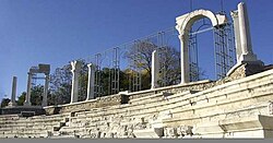
- The Antique Forum
- Thracian Tomb
- The Roman Baths
- The Samarsko Zname Monument
- Ayazmoto Park
- Defenders of Stara Zagora Memorial Complex
- Memorial House of Geo Milev
- The South Gate of Augusta Trajana
- The Opera House, built in 1925
- Stara Zagora Transmitter with one of the few Blaw-Knox Towers in Europe
- Neolithic Dwellings
Districts

- Bedechka - Gradinski (Бедечка - Градински, named at river Bedechka)
- Central City Part (includes Supercenter, Chayka & Zagorka) (Централна градска част (Суперцентър, Чайка и Загорка) - Chayka - Sea-gull, Zagorka - named at Zagorka brewery)
- Makedonski (Македонски - Macedonian) know also as Chumleka (Чумлека)
- Dabrava (Дъбрава - former village of Dabrava)
- Eastern Industrial Zone (Източна индустриална зона)
- Geo Milev (Гео Милев - named at Bulgarian poet)
- Golesh (Голеш)
- Industrial Zone (Индустриална Зона)
- Kazanski (Казански)
- Kolyo Ganchev (Кольо Ганчев - named at famous Bulgarian revolutionary)
- Lozenets (Лозенец - from лозе - vineyard)
- Mitropolit Metodiy Kusev (Митрополит Методий Кусев - named at famous Starozagorian bishop)
- Opalchenski (Опълченски - Volunteer's district named at Bulgarian voluntary army units) also known as Chaika (Чайка - Sea-Gull)
- Samara 1, 2 & 3- (Самара 1, 2 и 3 - named at sister city of Samara, Russia)
- Slaveykov (Славейков - named at famous Bulgarian poet Petko Slaveykov)
- Studentski grad - (Студентски град - Student town)
- Tri Chuchura north, center & south - (Три чучура север, център и юг - "Three spouts")
- Vasil Levski - (Васил Левски - named at famous Bulgarian revolutionary)
- Vazrazhdane - (Възраждане - Renaissance)
- Zheleznik (small & big) (Железник - named at former name of the city)
- Zora (Зора - Dawn)
Future districts :
- Atyuren (Атюрен - future district of the city)
- Bogomilovo (Богомилово - village of Bogomilovo)
- Hrishteni (Хрищени - village of Hrishteni)
- Malka Vereya (Малка Верея - Vereya - old name of the city, Malka - small, village of Malka Vereya)
Famous people
- Anna Tomowa-Sintow, dramatic soprano opera singer
- Vesselina Kasarova, coloratura mezzo soprano opera singer
- Vesselin Stoykov, Bass-bariton opera singer Web page
- Kiril Hristov, writer
- Stefan Kisyov, writer
- Anelia, pop-folk singer
- Maria, pop-folk singer and commercial model of Ariana beer.
Other
- Beroe Hill on Livingston Island, West Antarctica is named after this city, in its previous incarnation as Beroe.
- One of the two lighting factories Svetlina is situated here.
Twin towns and sister cities
Stara Zagora is twinned with:
 Radom, Poland[7]
 Larissa, Greece
 Samara, Russia
 County Down, United Kingdom
 Kruševac, Serbia
 Barreiro, Portugal
See also
References
- ^ a b c Template:Bg iconNational Statistical Institute - Main Towns Census 2011
- ^ a b Template:Bg icon Bulgarian Academy of Sciences
- ^ a b Template:Bg iconNational Statistical Institute - Towns population 1956-1992
- ^ Template:En icon Bulgarian National Statistical Institute - Census 2011
- ^ Template:En icon „WorldCityPopulation“
- ^ „pop-stat.mashke.org“
- ^ "Radom Official Website - Partner Cities".

 (in English and Polish) © 2007 Urząd Miasta Radom. Retrieved 2008-10-23.
External links
- Stara Zagora Regional museum of history
- Stara Zagora Tourist Information Centre
- Stara Zagora Economic Development Agency
- Maps, Population, Info & Facts about cities and villages in Stara Zagora municipality
- Programata Stara Zagora — the free cultural guide of Stara Zagora
- Information and links about Stara Zagora
- Information from Visit Bulgaria
- Chamber of commerce
- Real Photos from Stara Zagora
- News and videos from Stara Zagora


