
Tokushima (city)
Tokushima
徳島市 | |
|---|---|
 Top:Yoshino River Bridge, Second:Awa Odori on August, Tokushima Station, Third:Mount Bizan, Senshukaku Garden in Tokushima Castle, Bottom:Awa Jūrōbei House, Aibahama Park, all item for left to right | |
 Flag  Seal | |
 Location of Tokushima in Tokushima Prefecture | |
 | |
| Coordinates: 34°4′N 134°33′E / 34.067°N 134.550°E | |
| Country | |
| Region | Shikoku |
| Prefecture | |
| City Status | October 1, 1889 |
| Government | |
| • Mayor | Sawako Naitō |
| Area | |
| • Total | 191.52 km2 (73.95 sq mi) |
| Population (July 1, 2022) | |
| • Total | 249,865 |
| • Density | 1,300/km2 (3,400/sq mi) |
| Time zone | UTC+9 (JST) |
| Symbols | |
| • Tree | Elaeocarpus sylvestris |
| • Flower | Prunus serrulata |
| Phone number | 088-621-5111 |
| Address | 2-5 Saiwaichō, Tokushima-shi, Tokushima-ken 770-8571 |
| Website | Official website |
| Tokushima | |||||
|---|---|---|---|---|---|
| Japanese name | |||||
| Kanji | 徳島市 | ||||
| Hiragana | とくしまし | ||||
| |||||
Tokushima (徳島市, Tokushima-shi, Japanese: [tokɯ̥ꜜɕima]) is the capital city of Tokushima Prefecture on Shikoku island in Japan. As of 1 July 2022[update], the city had an estimated population of 249,865 in 122085 households and a population density of 1305 persons per km².[1] The total area of the city is 191.52 square kilometres (73.95 sq mi).
Geography[edit]
The city is situated in the north-eastern part of Tokushima Prefecture at the mouth of the Yoshino River. In terms of layout and organization, Tokushima displays the typical characteristics of a Japanese castle town. Most of the city is located in the Tokushima plain and is flat, but the symbol of the city, Mt. Bizan, rises in the center, creating a scenic landscape. The southern part is a mountainous area with forests.
Mountains[edit]
| Name | Height | Notes |
|---|---|---|
| Bizan (眉山) |
277 m | |
| Shiroyama (城山) |
62 m | |
| Nakatsu Mineyama (中津峰山) |
773 m | The highest mountain in the Tokushima City district. |
| Nishi Ryuo-san (西竜王山) |
495 m | |
| Higashi Ryuo-san (東龍王山) |
408m | |
| Kinobeyama (気延山) |
212 m | |
| Bentenyama (弁天山) |
6.1 m | Claimed to be the smallest natural mountain in Japan. |
Rivers[edit]
Neighbouring municipalities[edit]
Tokushima Prefecture
Demographics[edit]
Per Japanese census data,[2] the population of Tokushima has been growing steadily for the past century.
| Year | Pop. | ±% |
|---|---|---|
| 1920 | 140,534 | — |
| 1930 | 158,688 | +12.9% |
| 1940 | 164,572 | +3.7% |
| 1950 | 177,363 | +7.8% |
| 1960 | 203,326 | +14.6% |
| 1970 | 223,451 | +9.9% |
| 1980 | 249,343 | +11.6% |
| 1990 | 263,356 | +5.6% |
| 2000 | 268,218 | +1.8% |
| 2010 | 264,764 | −1.3% |
Climate[edit]
Tokushima has a humid subtropical climate (Köppen climate classification Cfa) with hot summers and cool winters. Precipitation is high, but there is a pronounced difference between the wetter summers and drier winters.
| Climate data for Tokushima (1991−2020 normals, extremes 1891−present) | |||||||||||||
|---|---|---|---|---|---|---|---|---|---|---|---|---|---|
| Month | Jan | Feb | Mar | Apr | May | Jun | Jul | Aug | Sep | Oct | Nov | Dec | Year |
| Record high °C (°F) | 22.5 (72.5) |
23.2 (73.8) |
26.4 (79.5) |
30.1 (86.2) |
32.9 (91.2) |
35.7 (96.3) |
38.4 (101.1) |
38.2 (100.8) |
36.2 (97.2) |
33.4 (92.1) |
27.1 (80.8) |
26.7 (80.1) |
38.4 (101.1) |
| Mean daily maximum °C (°F) | 10.0 (50.0) |
10.8 (51.4) |
14.3 (57.7) |
19.6 (67.3) |
24.0 (75.2) |
26.8 (80.2) |
30.6 (87.1) |
32.3 (90.1) |
28.5 (83.3) |
23.1 (73.6) |
17.7 (63.9) |
12.5 (54.5) |
20.9 (69.6) |
| Daily mean °C (°F) | 6.3 (43.3) |
6.8 (44.2) |
9.9 (49.8) |
15.0 (59.0) |
19.6 (67.3) |
23.0 (73.4) |
26.8 (80.2) |
28.1 (82.6) |
24.8 (76.6) |
19.3 (66.7) |
13.8 (56.8) |
8.7 (47.7) |
16.8 (62.2) |
| Mean daily minimum °C (°F) | 2.9 (37.2) |
3.1 (37.6) |
5.8 (42.4) |
10.6 (51.1) |
15.6 (60.1) |
19.8 (67.6) |
23.9 (75.0) |
24.9 (76.8) |
21.6 (70.9) |
15.9 (60.6) |
10.1 (50.2) |
5.2 (41.4) |
13.3 (55.9) |
| Record low °C (°F) | −5.4 (22.3) |
−6.0 (21.2) |
−3.6 (25.5) |
−0.7 (30.7) |
4.6 (40.3) |
9.7 (49.5) |
15.3 (59.5) |
16.6 (61.9) |
11.9 (53.4) |
4.5 (40.1) |
−1.3 (29.7) |
−4.3 (24.3) |
−6.0 (21.2) |
| Average precipitation mm (inches) | 41.9 (1.65) |
53.0 (2.09) |
87.8 (3.46) |
104.3 (4.11) |
146.6 (5.77) |
192.6 (7.58) |
177.0 (6.97) |
193.0 (7.60) |
271.2 (10.68) |
199.5 (7.85) |
89.2 (3.51) |
63.9 (2.52) |
1,619.9 (63.78) |
| Average snowfall cm (inches) | 1 (0.4) |
1 (0.4) |
0 (0) |
0 (0) |
0 (0) |
0 (0) |
0 (0) |
0 (0) |
0 (0) |
0 (0) |
0 (0) |
0 (0) |
2 (0.8) |
| Average precipitation days (≥ 0.5 mm) | 6.5 | 7.1 | 10.3 | 10.1 | 9.7 | 13.2 | 11.2 | 9.0 | 11.4 | 9.4 | 7.7 | 6.5 | 112.2 |
| Average relative humidity (%) | 61 | 61 | 61 | 62 | 67 | 75 | 77 | 73 | 72 | 69 | 66 | 63 | 67 |
| Mean monthly sunshine hours | 160.3 | 152.5 | 179.8 | 197.9 | 205.7 | 151.9 | 192.0 | 230.6 | 162.0 | 163.6 | 150.4 | 160.1 | 2,106.8 |
| Source: Japan Meteorological Agency[3] | |||||||||||||
History[edit]
As with all of Tokushima Prefecture, the area of Tokushima was part of ancient Awa Province. Tokushima was developed around Tokushima Castle, the seat of the Hachisuka clan, daimyo of Tokushima Domain under the Edo Period Tokugawa shogunate. Its prosperity was built on a strong indigo dye industry. Following the Meiji restoration, the city of Tokushima was established on October 1, 1889 with the creation of the modern municipalities system. At the time, it was the 10th largest city in Japan.
World War II air raid[edit]
Tokushima was selected as a target by the United States' XXI Bomber Command during World War II because of the city's role as an agricultural center for the region. On July 3, 1945, at 5:45 PM (JST) 137 aircraft took off to bomb Tokushima. 1,050 tons of incendiary bombs were dropped on Tokushima, destroying 74% of the built up areas of the city.[4] Over 1000 people were killed in the bombing (431 men, 553 women, 17 of unknown gender) and over 2000 people were injured. The number of incendiary bombs dropped on Tokushima City was enormous at 354,664, and since the population of Tokushima City was 115,508 in 1944, it is calculated that 3.07 incendiary bombs were dropped per citizen.
Government[edit]
Tokushima has a mayor-council form of government with a directly elected mayor and a unicameral city council of 30 members. Tokushima contributes ten members to the Tokushima Prefectural Assembly. In terms of national politics, the city is part of Tokushima 1st district of the lower house of the Diet of Japan.
Economy[edit]
Tokushima has been the economic center of eastern Shikoku since the Edo period, when prospered as a distribution center for indigo and timber, and was one of the leading commercial cities in Japan. It has a deep connection with the Kansai region especially Osaka, which has become even more prominent in modern times after the opening of the Akashi Kaikyo Bridge. Following the decline of the indigo industry, the accumulated wealth of the merchant class led to the development of banks and financial institutions, which in turn led to modern industries such as spinning, papermaking, pharmaceuticals, food processing and electric power. Although the city area was burnt to the ground due to the Tokushima air raid in World War II, it was quickly reconstructed. There are numerous industrial parks.
Agriculture and forestry both remain as major contributors the local economy. The Tokushima Plain in the Yoshino and Katsuura river basins have fertile agricultural land, and in addition to rice, some items such as cauliflower and carrots are major local products.
Education[edit]
Universities and colleges[edit]
Primary and secondary education[edit]
Tokushima has 30 public elementary schools and 18 public middle schools operated by the city government and nine public high schools operated by the Tokushima Prefectural Department of Education. There are also one private elementary school, three private middle schools and five private high schools. The prefecture also operates one night school and four special education schools for the disabled.
Transportation[edit]
Airport[edit]
- Tokushima Airport, which is located in neighboring town of Matsushige
Railway[edit]
![]() Shikoku Railway Company – Kōtoku Line
Shikoku Railway Company – Kōtoku Line
![]() Shikoku Railway Company – Mugi Line
Shikoku Railway Company – Mugi Line
- Tokushima - Awa-Tomida - Niken'ya - Bunkanomori - Jizōbashi
![]() Shikoku Railway Company – Tokushima Line
Shikoku Railway Company – Tokushima Line
Highways[edit]
 Tokushima Expressway
 Tokushima-Nanbu Expressway
 National Route 11
 National Route 28
 National Route 55
 National Route 192
 National Route 195
 National Route 318
 National Route 438
 National Route 439
Sister cities[edit]
 Saginaw, Michigan, United States, since December 1961
 Leiria, Portugal, since October 1969
 Dandong, Liaoning, China, since October 1991
Local attractions[edit]
- Tokushima Castle
- Tokushima Castle Museum
- Tokushima Archaeological Museum
- Tokushima Prefectural Museum
- Tokushima Domain Hachisuka clan cemetery, National Historic Site
- Dainichi-ji, 13th temple on the Shikoku Pilgrimage
- Jōraku-ji, 14th temple on the Shikoku Pilgrimage
- Awa Kokubun-ji, 15th temple on the Shikoku Pilgrimage
- Kan'on-ji, 16th temple on the Shikoku Pilgrimage
- Ido-ji, 17th temple on the Shikoku Pilgrimage
- Shibunomaruyama Kofun, National Historic Site
- Ichinomiya Jinja, one of the ichinomiya of former Awa Province
Culture[edit]
Every August, during the Obon Festival, Tokushima holds a cultural dance festival, the Awa Odori. Awa Odori literally translates as "Awa Dance" (Awa being Tokushima Prefecture's ancient name). During the festival, residents ranging from young children to professional dance troupes perform a distinctive style of Japanese traditional dance in regional costumes, accompanied by strings, drums, and singing (usually by the dancers themselves).
Sports[edit]
The city's Asty Tokushima arena hosted the official 2007 Asian Basketball Championship.
Gallery[edit]
-
 Tokushima Station Bus Terminal
 -
 Awa Dancing Festival, well-known Bon Festival
 -
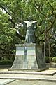 statue of Hachisuka Iemasa


References[edit]
- ^ "Tokushima city official statistics" (in Japanese). Japan.
- ^ Tokushima population statistics
- ^ 気象庁 / 平年値(年・月ごとの値). Japan Meteorological Agency. Retrieved May 19, 2021.
- ^ "21st Bomber Command Tactical Mission Report 247, 250, Ocr | PDF | Aviation | Armed Conflict".
External links[edit]
- Tokushima City official website (in Japanese)
- Tokushima City official website (in English)
 Tokushima travel guide from Wikivoyage
 Geographic data related to Tokushima (city) at OpenStreetMap
| Cities | |
|---|---|
| Districts | |
| International | |
|---|---|
| National | |
| Geographic | |
| Academics | |