
Nagorno-Karabakh: Difference between revisions
Providing more historucal details with reference to the sources |
RV unilateral POV edits. Rovoam, stop renewed revert and edit war. Stop manipulating with facts and people! All your deeds will be reported in your case in ArbCom one by one. |
||
| Line 58: | Line 58: | ||
The region has a total area of 4,400 km², and in [[1989]] it had a population of 192,000. The population at that time was mainly Armenian (76%) and [[Azeris|Azeri]] (23%), with [[Russia]]n and [[Kurds|Kurdish]] minorities. The capital is called ''[[Stepanakert]]'' (''Xankəndi'' in Azeri). Its other major city is [[Shusha]], which today lies in ruins. |
The region has a total area of 4,400 km², and in [[1989]] it had a population of 192,000. The population at that time was mainly Armenian (76%) and [[Azeris|Azeri]] (23%), with [[Russia]]n and [[Kurds|Kurdish]] minorities. The capital is called ''[[Stepanakert]]'' (''Xankəndi'' in Azeri). Its other major city is [[Shusha]], which today lies in ruins. |
||
Nagorno-Karabakh was one of the historical parts of [[Aghbania]], or [[Caucasian Albania]]. In ancient times the region was called [[Artsakh]]. In [[95 BCE]] it was conquered by [[Tigranes II]], ruler of the [[Kingdom of Armenia]]. Following the defeat of Tigranes II at the hands of the [[Romans]] in [[66 BCE]], Albanians regained Artsakh. Ancient Albanians and Armenians switched control over the territory until the early [[4th century]] CE, when the Albanians managed to reclaim Artsakh; eventually, in [[387]] CE, it became a part of Aghbania again. |
|||
[[Artsakh]] (Nagorno-Karabakh) was one of the historical parts of [[Armenia]]. |
|||
[[Christianity]] first came to Aghbania with the mission of St Eliseus yet in [[1st century]] CE. Christianity was widely accepted in the 5th century after [[Gregory the Illuminator|St Gregory the Illuminator]] converted and baptized Albanian king [[Urnayr]]. In [[488]] CE, following a church assembly near Aluan (situated in present-day Karabakh area), Christianity become the official religion in Aghbania. |
|||
For the first time Artsakh appeared under the name '''"Urtehke"''' or '''"Urtehini"''' as it is mentioned in [[Urartu|Urartianian]] cuneiform writings. |
|||
In the [[7th century|7th]] and [[8th century|8th]] centuries, the region was invaded by [[Arabs]], who pillaged it and converted a portion of the population to [[Islam]]. Under the Arabs, the Albanian church was subordinated to the [[Armenian Church]], which prompted rapid [[Gregorianization]] of the local population. Since the [[8th century]] Albania has diminished in size, and came to exist only as a [[principality]] of [[Khachen]] in Artsakh. |
|||
In the I century BC '''Artsakh''' is mentioned under the name of '''"Orhistene"'''. '''[[Strabo]]''' (born 63 BC or 64 BC, died ca. 24 AD) mentions '''Orhistene''' among the Armenian provinces (as well as ''Phavneni'' and ''Kombiseni''). |
|||
In the [[15th century]], the territory of Karabakh was part of the states of [[Kara Koyunlu]] and then [[Ak Koyunlu]]. In the early [[16th century]], after the fall of the Ak-Koyunlu state, control of the region passed to the [[Safavids|Safavid]] dynasty of [[Iran]], which created a [[Ganje-Karabakh province]] (beglarbekdom, bəylərbəyliyi); and in the mid-[[18th century]] the [[Karabakh khanate]] was formed. Karabakh passed to [[Imperial Russia]] by the [[Treaty of Gulistan]] in [[1813]], before the rest of Russia-controlled Armenian territories, which were incorporated into the Empire in [[1828]]. In [[1822]], the Karabakh khanate was dissolved, and the area became part of a Russian province which later formed Azerbaijan. |
|||
'''[[Ptolemy|Clavdius Ptolemeus]]''' (Κλαύδιος Πτολεμαίος; c. [[85]] – c. [[165]]) in his "Geography" informs, that "Great Armenia is located from the north to a part of Colchida, Iberia and Albania alone the line, which goes through the river Kir (Kura)" (see: ''Ptolemaios Klaudios'', "Geography", V, XII). |
|||
'''[[Pliny the Elder|Plinius Secundos]]''' ([[23]]–[[79]] AD, better known as Pliny the Elder) writes, that "the tribe of Albanians settled on the Caucasian mountains, reaches … the river Kir making border of Armenia and Iberia" (see ''Plinius the Second'', "The Natural history ", VI, 39). |
|||
'''[[Moses of Chorene|Movses Khorensky]]''' (V century AD) names Artsakh "Small Sunik" (Armenian "Pokr Sunik"). According to Moses, here, in Artsakh, young Grigorius (grandson of [[Gregory the Illuminator]]) was buried after he was killed on the field of Vatnyan (see ''Moves Khorensky'', "History of Armenia", III, chapter 3). |
|||
Other Armenian historian of V century - '''Egishe''' (Elishe) writes, that after defeat in battle (451 AD) many of the Armenians rising against Persians, ran "in the impassable countries Tmorika and in dense woods of Arstakh" (see ''Egishe'', "The Word about Armenian War", sec 6-th). |
|||
'''Busand''' (V century BC) tells, that Musheh Mamikonian has restored border between Armenia and Albania on the river Kura (Kir). |
|||
In "The Armenian Geography" (VII cent. AD) Artzakh is mentioned as 9-th of 15 provinces of ''Great Armenia''. |
|||
Since X century AD in historical works and sources Artzakh is mentioned under the name ''Khachen'' (the named of fortresses, the residence of the Armenian prince Sahla Smbatjan). The Byzantian emperor '''Konstantin Bagrjanorodny''' addressed his letters "to prince of Hachen - to Armenia". |
|||
The name ''Karabakh'' for the first time is mentioned on XIV century. At this time Artzakh has been broken up to tens Armenian princedoms, with the center in Gandzasar, under the Catholicos ruling. In 1672 Catholicos Pyotr in the letter to Russian tsar Alexey (Mihajlovich) names himself "the Catholicos of all Armenians". |
|||
After the [[Russian Revolution]] in [[1917]], Karabakh became part of the [[Transcaucasian Federation]], which soon dissolved into separate [[Armenia|Armenian]], [[Azerbaijan|Azeri]], and [[Georgia (country)|Georgian]] states. Azerbaijan claimed sovereignty over the province and sought to secure its claims with help from [[Ottoman Empire|Ottoman Turkey]]. Despite the fact that the Ottomans were defeated in the course of [[World War I]], Karabakh’s de-facto ownership by Azerbaijan was recognized in 1919 by the [[Allies#World_War_I|Allies]], who recognized [[Khosrov-bey Sultanov]] (appointed by the Azerbaijan government) as general-governor of Karabakh. Whereas Azerbaijan commended this decision as a recognition of its rights to the territory, the Armenian side criticized it, arguing that this decision was made because of the Allies' economic interests in the [[oil]] fields near Azerbaijan's capital, [[Baku]]. |
After the [[Russian Revolution]] in [[1917]], Karabakh became part of the [[Transcaucasian Federation]], which soon dissolved into separate [[Armenia|Armenian]], [[Azerbaijan|Azeri]], and [[Georgia (country)|Georgian]] states. Azerbaijan claimed sovereignty over the province and sought to secure its claims with help from [[Ottoman Empire|Ottoman Turkey]]. Despite the fact that the Ottomans were defeated in the course of [[World War I]], Karabakh’s de-facto ownership by Azerbaijan was recognized in 1919 by the [[Allies#World_War_I|Allies]], who recognized [[Khosrov-bey Sultanov]] (appointed by the Azerbaijan government) as general-governor of Karabakh. Whereas Azerbaijan commended this decision as a recognition of its rights to the territory, the Armenian side criticized it, arguing that this decision was made because of the Allies' economic interests in the [[oil]] fields near Azerbaijan's capital, [[Baku]]. |
||
Revision as of 06:19, 15 March 2005
Nagorno-Karabakh (from the Russian (Нагорный Карабах) variant of the Azeri name Dağlıq Qarabağ meaning mountainous black garden, the Armenian name is Լեռնային Ղարաբաղ — Lernayin Gharabagh, also referred to – mostly by Armenians – as Artsakh (Armenian: Արցախ)) is a region of Azerbaijan, in the southern Caucasus, located about 270 km (about 170 miles) west of the Azerbaijani capital of Baku. The region is predominantly ethnic Armenian, and is effectively under Armenian control. The local Armenian separatists declared independence from Azerbaijan on December 10 1991, and formed the "Nagorno-Karabakh Republic" (NKR). The NKR's sovereign status is not recognized by any country in the world.
| |||||
| Map of the region | |||||
| Map of the region. (Orange area indicates Armenian-controlled territory) | |||||
| Political status | Unrecognized | ||||
| Languages | Hayeren / Armenian | ||||
| Capital | Stepanakert / Xankəndi | ||||
| President | Arkadi Gukasian | ||||
| Independence – Declared – Celebrated1 – Recognition |
From Azerbaijan December 10 1991 September 2 1991 none | ||||
| Area | 4,400 km² | ||||
| Population2 Ethnic Composition3 |
145,000 (est. 2002) Over 95% Armenian 5% minorities | ||||
| Currency | Dram (AMD) (Armenian) | ||||
| Time zone | UTC +4 (DST +5) | ||||
| Internet TLD | none | ||||
| Calling Code | 374 ??? | ||||
| 1,2,3 nkrusa.org | |||||

The region has a total area of 4,400 km², and in 1989 it had a population of 192,000. The population at that time was mainly Armenian (76%) and Azeri (23%), with Russian and Kurdish minorities. The capital is called Stepanakert (Xankəndi in Azeri). Its other major city is Shusha, which today lies in ruins.
Nagorno-Karabakh was one of the historical parts of Aghbania, or Caucasian Albania. In ancient times the region was called Artsakh. In 95 BCE it was conquered by Tigranes II, ruler of the Kingdom of Armenia. Following the defeat of Tigranes II at the hands of the Romans in 66 BCE, Albanians regained Artsakh. Ancient Albanians and Armenians switched control over the territory until the early 4th century CE, when the Albanians managed to reclaim Artsakh; eventually, in 387 CE, it became a part of Aghbania again.
Christianity first came to Aghbania with the mission of St Eliseus yet in 1st century CE. Christianity was widely accepted in the 5th century after St Gregory the Illuminator converted and baptized Albanian king Urnayr. In 488 CE, following a church assembly near Aluan (situated in present-day Karabakh area), Christianity become the official religion in Aghbania.
In the 7th and 8th centuries, the region was invaded by Arabs, who pillaged it and converted a portion of the population to Islam. Under the Arabs, the Albanian church was subordinated to the Armenian Church, which prompted rapid Gregorianization of the local population. Since the 8th century Albania has diminished in size, and came to exist only as a principality of Khachen in Artsakh.
In the 15th century, the territory of Karabakh was part of the states of Kara Koyunlu and then Ak Koyunlu. In the early 16th century, after the fall of the Ak-Koyunlu state, control of the region passed to the Safavid dynasty of Iran, which created a Ganje-Karabakh province (beglarbekdom, bəylərbəyliyi); and in the mid-18th century the Karabakh khanate was formed. Karabakh passed to Imperial Russia by the Treaty of Gulistan in 1813, before the rest of Russia-controlled Armenian territories, which were incorporated into the Empire in 1828. In 1822, the Karabakh khanate was dissolved, and the area became part of a Russian province which later formed Azerbaijan.
After the Russian Revolution in 1917, Karabakh became part of the Transcaucasian Federation, which soon dissolved into separate Armenian, Azeri, and Georgian states. Azerbaijan claimed sovereignty over the province and sought to secure its claims with help from Ottoman Turkey. Despite the fact that the Ottomans were defeated in the course of World War I, Karabakh’s de-facto ownership by Azerbaijan was recognized in 1919 by the Allies, who recognized Khosrov-bey Sultanov (appointed by the Azerbaijan government) as general-governor of Karabakh. Whereas Azerbaijan commended this decision as a recognition of its rights to the territory, the Armenian side criticized it, arguing that this decision was made because of the Allies' economic interests in the oil fields near Azerbaijan's capital, Baku.
In 1920, Transcaucasia was taken over by the Bolsheviks who, in order to attract public support, promised that they would give Karabakh to Armenia along with Nakhchivan and Zangezur (presently part of Armenia, separating Azerbaijan from Nakhchivan proper). However, Moscow also had a far-reaching plans concerning Turkey, hoping that it would, with a little help from Russia, develop along Communist lines. Needing to appease Turkey, Moscow agreed to a compromise solution that gave Zangezur to Armenia while leaving Karabakh and Nakhchivan in Azerbaijan. As a result, the Nagorno-Karabakh Autonomous Region was established in the Azerbaijan SSR in 1923. Most of the decisions on the transfer of the territories and the establishment of new autonomous entities were made under pressure from Stalin, who is still blamed by both Azeris and Armenians for arbitrary decisions made against their national interests.
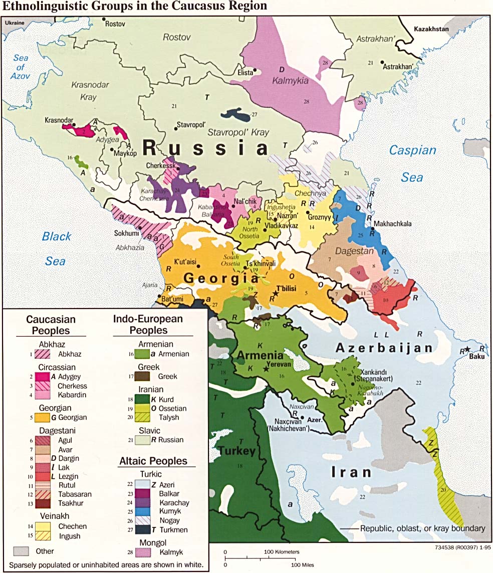
.png)
|
| Ethnic groups of the region in 1995: (See entire map) |
With the beginning of the dissolution of the Soviet Union in the late 1980s and early 1990s, the question of Nagorno-Karabakh reemerged. Complaining about "forced Azerification" of the region, the majority Armenian population started a movement to transfer it to Armenia. In November 1991, following the Karabakh Armenians' declaration of secession from Azerbaijan, the Azerbaijan Parliament retaliated by removing the autonomous status of the region. In response, the Nagorno-Karabakh Armenians held a referendum on December 10 1991, in which the overwhelming majority of the population voted for outright independence. The Azeri community of Nagorno-Karabakh boycotted the referendum, however.
The spiralling conflict led to violent actions against Armenians living in Sumgait, Baku, and elsewhere in Azerbaijan, and against Azerbaijanis living in Vardenis, Masis, Ghukark, and other regions of Armenia. As a result, a vast number of Azerbaijanis in Armenia and Armenians in Azerbaijan (except for Nagorno-Karabakh) were displaced. A land war between Armenia and Azerbaijan followed this civil violence. Military action was heavily influenced by the Russian military, who inspired and manipulated the rivalry between the two neighbouring nations in order to keep both under control.
Azerbaijanis were driven out of Nagorno-Karabakh and the territories neighboring Nagorno-Karabakh (populated by Azerbaijanis), which are still under control of the Armenian military. An unofficial cease-fire was reached on May 12 1994 through Russian negotiation, and continues today. Armenians remain in control of the Soviet-era autonomous region, a strip of land (called the Lachin corridor) linking it with the Republic of Armenia, as well as of the so-called security zone — strips of territory along the region's borders which had been used by Azerbaijani artillery during the war.
Today, Nagorno-Karabakh is a de facto independent state, which calls itself the Nagorno-Karabakh Republic. It is closely tied to the Republic of Armenia and uses its currency, the dram. Successive Armenian governments have resisted internal pressure to unite the two, fearing reprisals from Azerbaijan and the international community, which still considers Nagorno-Karabakh part of Azerbaijan. The politics of Armenia and Nagorno-Karabakh are so intermingled that a former president of the Nagorno-Karabakh Republic, Robert Kocharian, became first the prime minister (1997) and then the president of Armenia (1998 to the present).
At present, the mediation process is stalled, as both sides are equally intransigent. Azerbaijan insists that Armenian troops withdraw from all areas of Azerbaijan outside Nagorno-Karabakh and that all displaced persons be allowed to return to their homes before the status of Karabakh can be discussed. Armenia does not admit that Nagorno-Karabakh is legally part of Azerbaijan, arguing that because the region declared independence at the same time that Azerbaijan became an independent state, both of them are equally successor states of the Soviet Union. The Armenian government insists that the government of Nagorno-Karabakh be part of any discussions on the region's future, and rejects ceding occupied territory or allowing refugees to return prior to talks on the region's status.
In the latest episode, representatives of Armenia, Azerbaijan, France, Russia and the United States met in Paris and Key West, Florida in the Spring of 2001. The details of the talks have remained largely secret, but the parties are reported to have discussed non-hierarchical relationships between the central Azerbaijani government and the Karabakh Armenian authorities. Despite rumours that the parties were again close to a solution, the Azerbaijani authorities, both during Heydar Aliyev's period of office and after the accession of his son Ilham Aliyev in the October 2003 elections, have firmly denied that any agreement was reached in Paris or Key West.
Talks between Azerbaijanian and Armenian presidents, Ilham Aliyev and Robert Kocharyan, were held in September 2004 in Astana, Kazakhstan, on the sidelines of the Commonwealth of Independent States (CIS) summit. Reportedly, one of the suggestions put forward was the withdrawal of the occupying forces from the Azeri territories adjacent to Mountainous Karabakh, and holding referenda in Mountainous Karabakh and in Azerbaijan regarding the future status of the region.
See also
External links
- Regions and territories: Nagorno-Karabakh from the BBC
- ArtsakhWorld.com – an Armenian site about Nagorno-Karabakh
- Karabakh.org– an Azeri site about Nagorno-Karabakh
- Official site of the 'NKR Ministry of Foreign Affairs'
- Office of the Nagorno Karabakh Republic in the United States
- Karabakh Travel Guide
- Special Karabakh on Caucaz.com, Weekly Online about South Caucasus
- Nagorno-Karabakh Conflict Briefing