
North Rhine-Westphalia: Difference between revisions
No edit summary |
|||
| Line 32: | Line 32: | ||
}} |
}} |
||
'''North Rhine-Westphalia''' ({{lang-de|Nordrhein-Westfalen}} {{IPA-de|ˈnɔɐ̯tʁaɪn vɛstˈfaːlən||De-Nordrhein-Westfalen.ogg}}, usually shortened to ''NRW'', official short form NW) is the westernmost, most populous, and economically most powerful [[States of Germany|state]] of [[Germany]] |
'''North Rhine-Westphalia''' ({{lang-de|Nordrhein-Westfalen}} {{IPA-de|ˈnɔɐ̯tʁaɪn vɛstˈfaːlən||De-Nordrhein-Westfalen.ogg}}, usually shortened to ''NRW'', official short form NW) is the westernmost, most populous, and economically most powerful [[States of Germany|state]] of [[Germany]]. |
||
North Rhine-Westphalia includes the plains of the [[Lower Rhine]] region and parts of the [[Central Uplands]] (''Mittelgebirge'') up to the gorge of [[Porta Westfalica (gorge)|Porta Westfalica]]. The state comprises a land area of [[1 E+10 m²|34,083 km²]] (13,158 square miles) and shares borders with [[Belgium]] in the southwest and the [[Netherlands]] in the west and northwest. It has borders with the German states of [[Lower Saxony]] to the north and northeast, [[Rhineland-Palatinate]] to the south and [[Hesse]] to the southeast. |
North Rhine-Westphalia includes the plains of the [[Lower Rhine]] region and parts of the [[Central Uplands]] (''Mittelgebirge'') up to the gorge of [[Porta Westfalica (gorge)|Porta Westfalica]]. The state comprises a land area of [[1 E+10 m²|34,083 km²]] (13,158 square miles) and shares borders with [[Belgium]] in the southwest and the [[Netherlands]] in the west and northwest. It has borders with the German states of [[Lower Saxony]] to the north and northeast, [[Rhineland-Palatinate]] to the south and [[Hesse]] to the southeast. |
||
Revision as of 02:13, 11 April 2011
North Rhine-Westphalia (German: Nordrhein-Westfalen [ˈnɔɐ̯tʁaɪn vɛstˈfaːlən] , usually shortened to NRW, official short form NW) is the westernmost, most populous, and economically most powerful state of Germany.
North Rhine-Westphalia includes the plains of the Lower Rhine region and parts of the Central Uplands (Mittelgebirge) up to the gorge of Porta Westfalica. The state comprises a land area of 34,083 km² (13,158 square miles) and shares borders with Belgium in the southwest and the Netherlands in the west and northwest. It has borders with the German states of Lower Saxony to the north and northeast, Rhineland-Palatinate to the south and Hesse to the southeast.
History
Creation of the state
The state of North Rhine-Westphalia was established by the British military administration on 23 August 1946. Originally, it consisted of Westphalia and the northern parts of the Rhine Province, both formerly part of Prussia. In 1947, the former state of Lippe was merged with North Rhine-Westphalia, hence leading to the present borders of the state. The constitution of North Rhine-Westphalia was then ratified through a referendum.
Geography
Topography

Approximately half of the state is located in the relative shallow regions of the Westphalian Lowland or rather the Rhineland, both widely extending into the North German Plain. A few isolated mountain ranges are located within these lowlands, among them the Hohe Mark, the Beckum Hills, the Baumberge and the Stemmer Berge.
Towards the south as well as in the east of the state, the terrain rises. Here, the state has a stake in the Central Uplands, the Mittelgebirge. To this are counted the Weser Uplands with the Eggegebirge, the Wiehen Hills, the Wesergebirge and the Teutoburg Forest in the east, the Sauerland, the Bergisches Land, the Siegerland and the Siebengebirge in the south, as well as the left-Rhenish Eifel in the southwest of the state. The Rothaargebirge in the border region to Hesse exhibits elevations about 800 m above sea level. The highest among these mountains is the Langenberg with 843.2 m above sea level, then follow the Kahler Asten (840.7 m above sea level) and the Clemensberg (839.2 m above sea level).
The planimetrically ascertained centre of North Rhine-Westphalia is located in the south of Dortmund-Aplerbeck in the Aplerbecker Mark (51° 28' N, 7° 33' Ö). The westernmost point is situated near Selfkant close to the Dutch border, the easternmost near Höxter on the Weser. The southernmost point lies near Hellenthal in the Eifel region. The northernmost point is the NRW-Nordpunkt near Rahden in the northeast of the state. The Nordpunkt is located only 100 km to the south of the North Sea coast. The deepest natural dip is arranged in the district Zyfflich in the city of Kranenburg with 9.2 m above sea level in the northwest of the state. Though, the deepest point overground results from mining. The open-pit Hambach reaches at Niederzier a deep of 293 m below sea level. At the same time, this is the deepest man-made dip in Germany.
Rivers


The most important rivers flowing at least partially through North Rhine-Westphalia include: the Rhine, the Ruhr, the Ems, the Lippe, and the Weser. The Rhine is the by far most important river in North Rhine-Westphalia: it enters the state as Middle Rhine near Bad Honnef, where still being part of the Mittelrhein wine region. It changes into the Lower Rhine near Bad Godesberg and leaves North Rhine-Westphalia near Emmerich at a width of 730 metres. Almost immediately after entering the Netherlands, the Rhine splits into many branches.
The Pader, which flows entirely within the city of Paderborn, is considered Germany's shortest river.
Borders
The state's area covers a maximum distance of 291 km from north to south, and 266 km from east to west. The total length of the state's borders is 1,645 km. The following countries and states have a border with North Rhine-Westphalia:[1]
- Belgium (99 km)
- Netherlands (387 km)
- Lower Saxony (583 km)
- Hesse (269 km)
- Rhineland Palatinate (307 km)
For many, North Rhine-Westphalia is synonymous with industrial areas and urban agglomerations. However, the largest part of the state is used for agriculture (almost 52%) and forests (25%).[2]
Subdivisions
The state consists of five government regions (Regierungsbezirke), divided into 31 districts (Kreise) and 23 urban districts (kreisfreie Städte). In total, North Rhine-Westphalia has 396 municipalities (1997), including the urban districts, which are municipalities by themselves.
The five government regions of North Rhine-Westphalia each belong to one of the two Landschaftsverbände:
 The regional authorities Rhineland (green) and Westphalia-Lippe (red) | ||||||
(Regierungsbezirke) |
(Regierungsbezirke) |
|||||
 |
|
 |
| |||
 |
 | |||||
 | ||||||

| ||||
The ten largest cities of North Rhine-Westphalia
| align="center" Template:Highlight4|Pos. | align="center" Template:Highlight4|Name | align="center" Template:Highlight4|Pop. 2010 | align="center" Template:Highlight4|Area (km²) | align="center" Template:Highlight4|Pop. per km² | map |
|---|---|---|---|---|---|
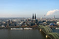
| 1 | Cologne | 1,000,660 | 405.15 | 2,470 | 
|
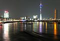
| 2 | Düsseldorf | 586,564 | 217.01 | 2,703 | |
| 3 | Dortmund | 580,688 | 280.37 | 2,071 | |
| 4 | Essen | 575,027 | 210.38 | 2,733 | |
| 5 | Duisburg | 501,564 | 232.81 | 2,154 | |
| 6 | Bochum | 385,626 | 145.43 | 2,652 | |
| 7 | Wuppertal | 359,237 | 168.37 | 2,134 | |
| 8 | Bielefeld | 326,925 | 257.83 | 1,268 | |
| 9 | Bonn | 312,818 | 141.22 | 2,215 | |
| 10 | Münster | 270,868 | 302.91 | 894 |
Demographics
North Rhine-Westphalia has a population of approximately 18 million inhabitants, and is centred around the polycentric Rhine-Ruhr metropolitan region, which includes the formerly industrial Ruhr region and the Rhenish cities of Bonn, Cologne and Düsseldorf. 30 of the 80 largest cities in Germany are located within North Rhine-Westphalia. The state's capital is Düsseldorf, the state's largest city is Cologne.
Religion
Roman Catholics make up 42%[3] of the people, while 28%[4] of the people are members of the Evangelical Church in Germany.
Culture
Flag and anthem
The flag of North Rhine-Westphalia is green-white-red with the combined coats of arms of the Prussian Rhine province (white line before green background, symbolizing the river Rhine), Westfalen (the white horse) and Lippe (the red rose.)
According to legend the horse in the Westphalian coat of arms is the horse that the Saxon leader Widukind rode after his baptism. Other theories attribute the horse to Henry the Lion. Some connect it with the Germanic rulers Hengist and Horsa.[citation needed]
A regional anthem is the Lied für NRW (Song for NRW).
Economy


In the 1950s and 1960s, Westphalia was known as Land von Kohle und Stahl or the land of coal and steel. In the post-WWII recovery, the Ruhr was one of the most important industrial regions in Europe, and contributed to the German Wirtschaftswunder. As of the late 1960s, repeated crises led to contractions of these industrial branches. On the other hand, producing sectors, particularly in mechanical engineering and metal and iron working industry, experienced substantial growth. Some of former coal mining areas retain high unemployment rates. Despite this structural change and an economic growth which was under national average, the 2007 GDP of 529.4 billion euro (21.8 percent of the total German GDP) made the land the economically most important in Germany, as well as one of the most important economical areas in the world.[5] Of Germany’s top 100 corporations, 37 are based in North Rhine-Westphalia. On a per capita base, however, Northrhine-Westfalia remains one of the weaker among the Western German lands.[6] As of November 2010, the unemployment rate is 8.1%, second highest among all western German states.[7]
North Rhine-Westphalia attracts companies from both Germany and abroad, with 26 of the 50 largest German companies based in Germany's most westerly federal state. These include leading German corporations such as E.ON (energy), Deutsche Telekom (telecommunications), Deutsche Post World Net (logistics), Metro AG (food trade), ThyssenKrupp (automotive supplier), RWE (energy) and Rewe Gruppe (trade). The state can rightly claim the most foreign direct investments (FDI) anywhere in Germany.[8] With 28.7 percent (187.6 billion euros) North Rhine-Westphalia recorded by far the highest direct investment share in Germany of all 16 federal states in 2008.[9]
Around 11,500 foreign companies from the most important investment countries control their German or European operations from bases in North Rhine-Westphalia. This means that almost a quarter of the foreign companies in Germany are domiciled in North Rhine-Westphalia. These include many international global players such as 3M, BP, Ericsson, Ford, LG Electronics, QVC, Sony, Renault, Toyota, and Vodafone. The companies employ a total of over 582,000 people. Their activities range from pure production to sophisticated services.
The Ruhr region, formerly known as the "land of coal and steel" (Land von Kohle und Stahl), has - since the 1960s - undergone a significant structural change away from coal mining and steel industry. Many rural parts of Eastern Westphalia, Bergisches Land and the Lower Rhine ground their economy on "Hidden Champions" in various sectors.
Education
[[File:1196-18-rwth-aachen-hg-von-hendrik-brixius.jpg|thumb|RWTH Aachen is one of Germany's leading universities of technology and was chosen by DFG as one of nine German Universities of Excellence North Rhine-Westphalia is home to 14 universities and over 50 partly postgraduate colleges, with a total of over 500,000 students.[10] Largest and oldest university is the University of Cologne (Universität zu Köln), originally founded in 1388 AD.
Politics
History of politics in North Rhine-Westphalia
From 1966 to 2005, North Rhine-Westphalia was continuously governed by the Social Democrats or SPD-led governments. The 2005 state election granted the CDU an unexpected victory. Their top candidate Jürgen Rüttgers formed a coalition government with the FDP. With the result of the 2010 state elections, this government lost its majority in parliament. After many coalition talks, SPD and the Greens have agreed on a minority government.
List of Ministers-President
These are the Ministers-president (German: Ministerpräsident) of the Federal State (German: Bundesland) of North-Rhine Westphalia (NRW):
| Ministers-president of North Rhine-Westphalia | |||||
|---|---|---|---|---|---|
| No. | Name | Born-Died | Party affiliation | Start of Tenure | End of Tenure |
| 1 | Rudolf Amelunxen | 1888–1969 | Zentrum | 1946 | 1947 |
| 2 | Karl Arnold | 1901–1958 | CDU | 1947 | 1956 |
| 3 | Fritz Steinhoff | 1897–1969 | SPD | 1956 | 1958 |
| 4 | Franz Meyers | 1908–2002 | CDU | 1958 | 1966 |
| 5 | Heinz Kühn | 1912–1992 | SPD | 1966 | 1978 |
| 6 | Johannes Rau | 1931–2006 | SPD | 1978 | 1998 |
| 7 | Wolfgang Clement | *1940 | SPD | 1998 | 2002 |
| 8 | Peer Steinbrück | *1947 | SPD | 2002 | 2005 |
| 9 | Jürgen Rüttgers | *1951 | CDU | 2005 | 2010 |
| 10 | Hannelore Kraft | *1961 | SPD | 2010 | incumbent |
The results of the North Rhine-Westphalia state election, 2010 were as follows. Voter turnout was at 59%, a decrease of 4% over the previous election in 2005. Template:North Rhine-Westphalia state election, 2010
Photo gallery
-
-
-

-

-
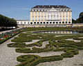 Augustusburg Palace in Brühl, North Rhine-Westphalia.


Notes and references
- ^ Length of borders taken from Statistisches Jahrbuch NRW 2005, 47. Jahrgang, Landesamt für Datenverarbeitung und Statistik Nordrhein-Westfalen, p. 22
- ^ Tatsachen über Deutschland (2003) Nordrhein-Westfalen, p. 44
- ^ chiesa cattolica http://www.dbk.de/imperia/md/content/kirchlichestatistik/bev-kath-l__nd-2008.pdf
- ^ EKD http://www.ekd.de/download/kirchenmitglieder_2007.pdf
- ^ Ministerium für Wirtschaft, Mittelstand und Energie des Landes Nordrhein-Westfalen: Konjunkturindikatoren NRW
- ^ Arbeitskreis Volkswirtschaftliche Gesamtrechnungen der Länder: Volkswirtschaftliche Gesamtrechnungen der Länder
- ^ Bundesagentur für Arbeit: Arbeitslosenzahlen im November 2010. -Länder und Kreise-
- ^ Rivergate | Federal States of Germany[dead link]
- ^ New European Economy | FDI
- ^ innovation.nrw.de: students in NRW by university or college, 2010
External links
- Official Government Portal
- The Landtag of North Rhine-Westphalia
- Tourism
- Information and resources on the history of Westphalia on the Web portal "Westphalian History"
- Guidelines for the integration of the Land Lippe within the territory of the federal state North-Rhine-Westphalia of 17th January 1947
- North Rhine-Westphalia images from Cologne and Duesseldorf to Paderborn and Muenster
| States |
|  |
|---|---|---|
| City-states | ||
| Former states |
| |
