
Ranville: Difference between revisions
Content deleted Content added
mention of book featuring Ranville. |
No edit summary |
||
| Line 2: | Line 2: | ||
|name = Ranville |
|name = Ranville |
||
|image = FranceNormandieRanvilleEgliseClocher.jpg |
|image = FranceNormandieRanvilleEgliseClocher.jpg |
||
|image coat of arms = |
|image coat of arms = Blason Fam Fr Guernon.svg |
||
|region = Basse-Normandie |
|region = Basse-Normandie |
||
|department = Calvados |
|department = Calvados |
||
Revision as of 16:53, 2 February 2014
Ranville | |
|---|---|
 | |
 Coat of arms | |
Location of Ranville  | |
| Country | France |
| Region | Normandy |
| Department | Calvados |
| Arrondissement | Caen |
| Canton | Cabourg |
| Intercommunality | Campagne et Baie de L'Orne |
| Government | |
| • Mayor (2008–2014) | Jean-Luc Adélaïde |
| Area 1 | 8.42 km2 (3.25 sq mi) |
| Population (2008) | 1,703 |
| • Density | 200/km2 (520/sq mi) |
| Time zone | UTC+01:00 (CET) |
| • Summer (DST) | UTC+02:00 (CEST) |
| INSEE/Postal code | 14530 /14860 |
| Elevation | 1–49 m (3.3–160.8 ft) (avg. 26 m or 85 ft) |
| 1 French Land Register data, which excludes lakes, ponds, glaciers > 1 km2 (0.386 sq mi or 247 acres) and river estuaries. | |
You can help expand this article with text translated from the corresponding article in French. (December 2008) Click [show] for important translation instructions.
|
Ranville is a commune in the Calvados department in the Basse-Normandie region in northwestern France.
Ranville was the first French village liberated on D-Day. The village was liberated by the British 13th Parachute Battalion, commanded by Lieutenant-Colonel Peter Luard. The château du Heaume in the village was subsequently used by the headquarters of the British 6th Airborne Division.
The village features heavily in the book "13 - Lucky For Some" which is about the history of the 13th (Lancashire) Parachute Battalion. There are many then and now photographs as well as maps and diagrams of battles that took place in the region.
Population
| Year | Pop. | ±% |
|---|---|---|
| 1962 | 883 | — |
| 1968 | 1,005 | +13.8% |
| 1975 | 1,519 | +51.1% |
| 1982 | 1,690 | +11.3% |
| 1990 | 1,681 | −0.5% |
| 1999 | 1,896 | +12.8% |
| 2008 | 1,703 | −10.2% |
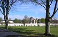
Sights
Gallery
-
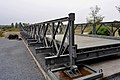 A Bailey bridge section at the Memorial Pegasus museum in Ranville
 -

-
-


See also
References
Wikimedia Commons has media related to Ranville.
This Calvados geographical article is a stub. You can help Wikipedia by expanding it. |