
Mannarkkad: Difference between revisions
Krassotkin (talk | contribs) m (GR) File renamed: File:Shareef 105.jpg → File:Mannarkkad.jpg File renaming criterion #1: At the original uploader's request.To specify the location |
m (GR) File renamed: File:Shareef 082.jpg → File:Mannarkkad82.jpg File renaming criterion #2: To change from a meaningless or ambiguous name to a name that describes what the image displays. |
||
| Line 88: | Line 88: | ||
File:Shareef 026.jpg|Kanhirappuzha Village |
File:Shareef 026.jpg|Kanhirappuzha Village |
||
File:Shareef 027.jpg|Kanhirappuzha Town |
File:Shareef 027.jpg|Kanhirappuzha Town |
||
File: |
File:Mannarkkad82.jpg|Mannarkkad |
||
</gallery> |
</gallery> |
||
Revision as of 08:09, 10 February 2016
Mannarkkad
മണ്ണാ൪ക്കാട്, மன்னார்க்காடு | |
|---|---|
city | |
 Kanhirappuzha Dam | |
| Nickname: Gateway to Silent valley National Park | |
| Country | |
| State | Kerala |
| District | Palakkad District |
| Government | |
| • Type | municipality |
| • Body | municipality |
| • Rank | 24 |
| Elevation | 76 m (249 ft) |
| Demonym | Mannarkkadans |
| Languages | |
| • Official | Malayalam, English, Tamil, Kannada, Badaga, Hindi, Tribal Language, Kodava |
| Time zone | UTC+5:30 (IST) |
| Telephone code | + 91 (0) 4924 |
| Vehicle registration | KL-50 |
Mannarkkad, formerly known as Mannarghat, is a town in the Palakkad district of Kerala State, South India. It is the headquarters of Mannarkkad Taluk, and is one of the largest revenue Taluks in Kerala.
Location
It is situated 40 km north-east of the district headquarters Palakkad, on the way to Kozhikode (NH 213) and in the foothills of the Western Ghats. Silent Valley (a tropical evergreen rain forest with an unbroken evolutionary history of 50 million years) is only 35 km from Mannarkkad and also the Well Known Tourist Place Kanjirappuzha Dam is only 12 km from Mannarkkad.
Geography
Mannarkkad is located at 10°59′N 76°28′E / 10.98°N 76.47°E.[1] It has an average elevation of 76 m (249 ft).
Notable nearby locations
- Kanjirappuzha Dam & Gardens: 12 km
- Silent Valley National Park: 23 km
- Malampuzha Dam & Gardens: 40 km
- Siruvani dam 25 km
- Salim Ali Bird Sanctuary Anakkatti:39 km
- Attappady Hills:10 km
- Nottamala Hills, 1 km
- Patrakkadavu Water falls 8 km
- Meenvallam & Atla Water Falls 20 km
Politics
Mannarkkad assembly constituency is part of Palghat (Lok Sabha constituency).[2]
Image gallery
-
 Attapady Road
 -
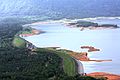 Kanhirappuzha Dam
 -
 Nellippuzha Bridge
 -
 Kanhirappuzha Village
 -
 Kanhirappuzha Town
 -
 Mannarkkad


References
- ^ Falling Rain Genomics, Inc - Mannarkkad
- ^ "Assembly Constituencies - Corresponding Districts and Parliamentary Constituencies" (PDF). Kerala. Election Commission of India. Retrieved 2008-10-19.
External links
| Taluks of Palakkad District, Kerala |
|---|
| Alathur • Chittur • Mannarkkad • Ottapalam • Pattambi • Palakkad |