
El Morro National Monument: Difference between revisions
m add/change/refine category; MOS fixes; all included cat, replaced: = hd → = hd | nocat = yes, nrhp_type = hd → nrhp_type = hd | nocat = yes, nocat = yes | nocat = yes → nocat = yes using AWB |
Rescuing 1 sources and tagging 0 as dead. #IABot (v1.5.2) |
||
| Line 21: | Line 21: | ||
| designated_other1 = New Mexico |
| designated_other1 = New Mexico |
||
| designated_other1_date = May 21, 1971 |
| designated_other1_date = May 21, 1971 |
||
| designated_other1_number = [http://www.nmhistoricpreservation.org/assets/files/registers/2012%20Report_%20Section%203_%20Arranged%20by%20Number.pdf 59] |
| designated_other1_number = [https://web.archive.org/web/20141110122215/http://www.nmhistoricpreservation.org/assets/files/registers/2012%20Report_%20Section%203_%20Arranged%20by%20Number.pdf 59] |
||
| designated_other1_num_position = bottom |
| designated_other1_num_position = bottom |
||
| image = |
| image = |
||
Revision as of 17:46, 18 September 2017
| El Morro National Monument | |
|---|---|
IUCN category V (protected landscape/seascape) | |
 | |
| Location | Cibola County, New Mexico, USA |
| Nearest city | El Morro, New Mexico |
| Coordinates | 35°2′18″N 108°21′12″W / 35.03833°N 108.35333°W |
| Area | 1,278.72 acres (5.1748 km2) 1,039.92 acres (420.84 ha) federal |
| Created | December 8, 1906 |
| Visitors | 59,422 (in 2016)[1] |
| Governing body | National Park Service |
| Website | El Morro National Monument |
El Morro National Monument | |
  | |
| Area | 221 acres (89 ha) |
| Built | 1605 |
| NRHP reference No. | 66000043[2] |
| NMSRCP No. | 59 |
| Significant dates | |
| Added to NRHP | October 15, 1966 |
| Designated NMSRCP | May 21, 1971 |
El Morro National Monument is located on an ancient east-west trail in western New Mexico. The main feature of this National Monument is a great sandstone promontory with a pool of water at its base.
As a shaded oasis in the western U.S. desert, this site has seen many centuries of travelers. The remains of a mesa top pueblo are atop the promontory where between about 1275 to 1350 AD, up to 1500 people lived in this 875 room pueblo. The Spaniard explorers called it El Morro (The Headland). The Zuni Indians call it "A'ts'ina" (Place of writings on the rock). Anglo-Americans called it Inscription Rock. Travelers left signatures, names, dates, and stories of their treks. While some of the inscriptions are fading, there are still many that can be seen today, some dating to the 17th century. Among the Anglo-American emigrants who left their names there in 1858 were several members of the Rose-Baley Party, including Leonard Rose and John Udell.[3] Some petroglyphs and carvings were made by the Ancestral Puebloan centuries before Europeans started making their mark. In 1906, U.S. federal law prohibited further carving.
The many inscriptions, water pool, pueblo ruins, and top of the promontory are all accessible via park trails.
It is on the Trails of the Ancients Byway, one of the designated New Mexico Scenic Byways.[4]
Gallery
-
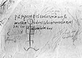 Inscription by Juan de Oñate in 1605. This is the oldest historical inscription at El Morro.
 -
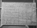 Inscription recording a 1629 expedition by Francisco Manuel de Silva Nieto
 -
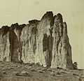 El Morro in 1868, photographed by Alexander Gardner
 -
 Native American petroglyph
 -
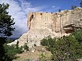 Sandstone bluff at El Morro
 -
 Ponderosa pine along Mesa Top trail loop


See also
- National Register of Historic Places listings in Cibola County, New Mexico
- List of National Monuments of the United States
References
- ^ "NPS Annual Recreation Visits Report". National Park Service. Retrieved June 12, 2017.
- ^ "National Register Information System". National Register of Historic Places. National Park Service. July 9, 2010.
- ^ Weigle, Marta and White, Peter (2003). The Lore of New Mexico, p. 56. University of New Mexico Press
- ^ Trail of the Ancients. Archived August 21, 2014, at the Wayback Machine New Mexico Tourism Department. Retrieved August 14, 2014.
- United States Government Printing Office (1995). El Morro National Monument. GPO 387-038/00173
External links
- Official National Park Service site
- American Southwest, a National Park Service Discover Our Shared Heritage Travel Itinerary
| Topics | |
|---|---|
| Lists by state |
|
| Lists by insular areas | |
| Lists by associated state | |
| Other areas | |
| Related | |
- IUCN Category V
- Petroglyphs in New Mexico
- National Park Service National Monuments in New Mexico
- Museums in Cibola County, New Mexico
- Native American museums in New Mexico
- Protected areas established in 1906
- Protected areas of Cibola County, New Mexico
- Historic districts on the National Register of Historic Places in New Mexico
- New Mexico geography stubs
- Western United States protected area stubs