Dighton Rock State Park
| Dighton Rock State Park | |
|---|---|
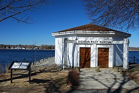
 Dighton Rock Museum
1893 1853 | |
| Location | Berkley, Bristol, Massachusetts, United States |
| Coordinates | 41°48′46″N 71°06′23″W / 41.81278°N 71.10639°W[1] |
| Area | 98 acres (40 ha)[2] |
| Elevation | 66 ft (20 m)[1] |
| Established | 1955 |
| Governing body | Massachusetts Department of Conservation and Recreation |
| Website | Dighton Rock State Park |
Dighton Rock State Park is a public recreation area and historic preserve located on the eastern shore of the Taunton River in the town of Berkley, Massachusetts. The 98-acre (40 ha) state park is the site of a small museum that houses the Dighton Rock, an 11-foot-high (3.4 m) glacial erratic, covered with petroglyphs, that once sat on the banks of the river. It is managed by the Massachusetts Department of Conservation and Recreation.[3]
Park history
[edit]From 1889 to 1955, the park was owned and managed by the Old Colony Historical Society. It was acquired by the state in 1955.[4][5]
Activities and amenities
[edit]In addition to the museum, which is only open by appointment, the park features non-motorized boating, fishing, picnicking, and trails that are used for hiking, biking, and cross-country skiing.[3]
References
[edit]- ^ a b "Dighton Rock State Park". Geographic Names Information System. United States Geological Survey, United States Department of the Interior.
- ^ "2012 Acreage Listing" (PDF). Department of Conservation and Recreation. April 2012. Archived from the original (PDF) on June 7, 2017. Retrieved March 14, 2017.
- ^ a b "Dighton Rock State Park". MassParks. Executive Office of Energy and Environmental Affairs. Retrieved August 2, 2013.
- ^ "A Guide to Related Archival Collections" (PDF). Massachusetts Department of Conservation and Recreation. June 9, 2015. p. 125. Retrieved March 14, 2017.
- ^ "Chapter 538. An act authorizing the department of natural resources to acquire certain land in the Town of Berkley" (PDF). Acts, 1955. Commonwealth of Massachusetts. July 13, 1955. pp. 437–438. Retrieved March 14, 2017.
External links
[edit]- Dighton Rock State Park Department of Conservation and Recreation
 Media related to Dighton Rock State Park at Wikimedia Commons


