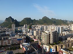
Babu District
Appearance
Babu
八步区 · Bazbu Guh Patpo | |
|---|---|
 | |
| Coordinates: 24°24′40″N 111°32′38″E / 24.41111°N 111.54389°E | |
| Country | China |
| Autonomous region | Guangxi |
| Prefecture-level city | Hezhou |
| District seat | Chengdong Subdistrict |
| Area | |
| • Total | 5,334 km2 (2,059 sq mi) |
| Population (2020 census)[1] | |
| • Total | 655,994 |
| • Density | 120/km2 (320/sq mi) |
| Time zone | UTC+8 (China Standard) |
| Website | www |
Babu (Chinese: 八步; pinyin: Bābù) is a district of the city of Hezhou, Guangxi, China.
Administrative divisions
[edit]Babu District is divided into 3 subdistricts, 12 towns and 1 ethnic township:[2]
- Babu Subdistrict (八步街道)
- Chengdong Subdistrict (城东街道)
- Jiangnan Subdistrict (江南街道)
- Hejie Town (贺街镇)
- Butou Town (步头镇)
- Liantang Town (莲塘镇)
- Daning Town (大宁镇)
- Nanxiang Town (南乡镇)
- Guiling Town (桂岭镇)
- Kaishan Town (开山镇)
- Lisong Town (里松镇)
- Xindu Town (信都镇)
- Lingfeng Town (灵峰镇)
- Renyi Town (仁义镇)
- Pumen Town (铺门镇)
- Huangdong Yao Ethnic Township (黄洞瑶族乡)
References
[edit]- ^ "贺州市2020年第七次全国人口普查主要数据公报" (in Chinese). Government of Yuling. 2021-05-28.
- ^ 2023年统计用区划代码和城乡划分代码:八步区 (in Simplified Chinese). National Bureau of Statistics of China.

