
Kurdistan
.jpg) Kurdish-Inhabited Areas | |
| Location | Parts of Turkey, Iran, Iraq, Syria, and Armenia |
|---|---|
| Area (Est.) | 190,000 km² - 390,000 km² 74,000 sq.mi - 151,000 sq.mi |
| Population | 25–30 Million (Est.)[1] |
Kurdistan (Kurdish: Kurdistan/كوردستان, literally meaning "the land of Kurds"[2]; Ancient: Corduene, old: Koordistan, Curdistan, Kurdia, also Kurdish: Kurdewarî) refers to the lands in the Middle east where Kurdish language is the traditional language in use, generally nowadays as a minority language by the Kurdish people.
As a traditional ethnographic region, Kurdistan is generally held to include the contiguous regions in northern and northeastern Mesopotamia with large Kurdish populations. From a political standpoint, Iraqi Kurdistan is the only region which has gained official recognition internationally as a federal entity.[3] Most of the Kurdish people who live in non-Kurdish majority areas of Turkey, Iran and Syria are expecting Kurdistan to be an official independent state within these countries, so that all Kurds can move to Kurdistan from other areas and start living there.
Etymology
The region was known by various cognates of the word Kurd during the ancient history of the Mesopotamia. The ancient Sumerians referred to it as Kur-a, Gutium, or Land of Karda, the Elamites as Kurdasu, the Akkadians as Kurtei, the Assyrians as Kurti, the Babylonians as Qardu, the Greeks as Carduchoi and the Romans as Corduene. The ending of —ene was the Greek suffix for satrapies, as the ending of —stan in the word Kurdistan is the Kurdish suffix for toponyms meaning 'land of', however the original Kurdish equivalent for Kurdistan used by Kurds themselves, has been the word 'Kurdewarî'. The term land of Kuti or Guti was used to refer to the areas to northeast of Babylonia [4], roughly corresponding to what is today Iraqi and Iranian Kurdistan, and in the wider concept to refer to somewhere in or the whole areas to the east of Tigris[5]. At the same time the term land of Karda or Beth Kardu was used for the tract situated between Lake Van, Lake Urmia and the upper Tigris, to the north of land of Kuti; and to the west of both in upper Mesopotamia was situated the land of Arian Mitannis. One of the First records of using the term of Kurdistan is by Sultan Sanjar the Seljuk King in the 12th century. He formed a province named Kurdistan centered at Bahar situated to the northeast of Hamadan. This province was located between Azarbaijan and Luristan. It included the regions of Hamadan, Dinawar, Kermanshah and Senna, to the east of the Zagros and to the west of Sharazur (Kirkuk) and Khuftiyan, on the river Zab.[6]
History
Ancient period
Much of Kurdistan corresponds roughly with the ancient Kingdom of Gutium, which is mentioned in cuneiform records about 2400 BC, and had its capital at Arraphkha. [7]
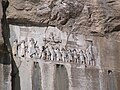
The tract to this day known as Kurdistan, the high mountain region south and south-east of Lake Van between Persia and Mesopotamia, was in the possession of Kurds from before the time of Xenophon, and was known as the country of the Carduchi (Greek: Καρδούχοι), as Cardyeneor Cordyene.[8]

At their peak, the Romans ruled large Kurdish-inhabited areas, particularly the western and northern Kurdish areas in the Middle East. Kingdoms like Corduene were vassal states of the Roman Empire. From 189 BC to AD 384, the ancient kingdom of Corduene ruled northern Mesopotamia. It was situated to the east of Tigranocerta (i.e., to the east and south of present-day Diyarbakır in south-eastern Turkey). It became a vassal state of the Roman Republic in 66 BC. It remained allied with the Romans until AD 384.
Some of the ancient districts of Kurdistan and their corresponding modern names are listed below [9].
- Corduene or Gordyene (Siirt, Bitlis and Şırnak)
- Sophene (Diyarbakır)
- Zabdicene or Bezabde (Gozarto d'Qardu or Jazirat Ibn Umar or Cizre)
- Basenia (Bayazid)
- Moxoene (Muş)
- Nephercerta (Miyafarkin)
- Artemita (Van)
Medieval period

In the second half of the 10th century, Kurdistan was shared amongst five big Kurdish principalities. In the North the Shaddadid (951–1174) (in parts of Armenia and Arran) and the Rawadid (955–1221) (in Tabriz and Maragheh), in the East the Hasanwayhid (959–1015) and the Annazid (990–1116) (in Hulwan, Kermanshah and Khanaqin) and in the West the Marwanid (990–1096) of Diyarbakır.
Kurdistan in the Middle Ages was a collection of semi-independent states called "emirates". A comprehensive history of these states and their relationship with their neighbors is given in the famous textbook of "Sharafnama" written by Prince Sharaf al-Din Bitlisi in 1597.[10][11] The most famous Kurdish Emirates included Baban, Soran, Badinan and Garmiyan in present-day Iraq; Bakran, Botan (or Bokhtan) and Badlis in Turkey, and Mukriyan and Ardalan in Iran.
Modern period
In the 16th century, the Kurdish-inhabited areas were split between Safavid Iran and the Ottoman Empire after prolonged wars. The first important division of Kurdistan occurred in the aftermath of the Battle of Chaldiran in 1514. This division was formalized in the Treaty of Zuhab in 1639[12]. Before World War I, most Kurds lived within the boundaries of the Ottoman Empire in the province of Kurdistan. After the collapse of the Ottoman Empire, the Allies agreed and planned to create several countries within its former boundaries. Originally Kurdistan, along with Armenia, was to be one of them, according to the never-ratified Treaty of Sèvres. However, the reconquest of these areas by Kemal Atatürk and other pressing issues caused the Allies to accept the renegotiated Treaty of Lausanne, accepting the border of modern Republic of Turkey and leaving the Kurds without a self-ruled region. Other Kurdish areas were assigned to the new British and French mandated states of Iraq and Syria under both treaties.
The Kurdish delegation made a proposal at the San Francisco Peace Conference in 1945, showing the geographical extent of Kurdistan as claimed by the Kurds. This proposal encompasses an area extending from the Mediterranean shores near Adana to the shores of Persian Gulf near Bushehr, and it includes the Lur inhabited areas of southern Zagros[13][14].
Since World War I, Kurdistan has been divided between several states, in all of which Kurds are minorities. At the end of the First Gulf War, Allies established the safe haven in northern Iraq. Amid the withdrawal of Iraqi forces from three northern provinces, Iraqi Kurdistan emerged as an autonomous entity inside Iraq, with its own local government and parliament in 1992.
People
In addition to Kurds who comprise the majority of the population of the region there are also communities of Arab, Armenian, Assyrian, Azeri, Jewish, Ossetian, Persian, and Turkish people traditionally scattered throughout the region alongside Kurds. Most of its inhabitants being Muslim there are also significant numbers of various other religious sects such as Yazidi, Yarsan, Alevi, Christian, Jewish, Sarayi, Bajwan and Haqqa etc.
Geography

According to Encyclopædia Britannica, Kurdistan covers about 74,000 sq mi (191,660 km²), and its chief towns are Diyarbakır, Bitlis, and Van in Turkey, Mosul and Arbil [Kirkuk was previously stated here however the people do not get to vote until later this year 2007] in Iraq, and Kermanshah, Sanandaj and Mahabad in Iran.[15] According to the Encyclopaedia of Islam, Kurdistan covers around 190,000 km² in Turkey, 125,000 km² in Iran, 65,000 km² in Iraq, and 12,000 km² in Syria and the total area of Kurdistan is estimated at approximately 392,000 km²[16]. Others estimate as many as 40 million Kurds live in Kurdistan, which covers an area as big as France. The Kurdistan Province in Iran and Iraqi Kurdistan are both included in the usual definition of Kurdistan.

Iranian Kurdistan encompasses Kurdistan Province and greater parts of West Azarbaijan, Kermanshah, Īlām provinces. Iraqi Kurdistan is divided into six governorates, three of which — and parts of others — are under the control of Kurdistan Regional Government. Syrian Kurdistan is mostly located in present-day northeastern Syria. This region covers greater part of the province of Al Hasakah. The main cities in this region are Al-Qamishli (Kurdish: Qamişlû) and Al Hasakah (Kurdish: Hesaka). Another region with a significant Kurdish population is in the northern part of Syria. The Kurdish-inhabited northern and northeastern parts of Syria in Kurdish is called "Kurdistana Binxetê". [17] (see Demographics of Syria and [18]), a large area of south eastern Turkey is also home to estimated 15 to 20 million Kurds.
Forests
Although Kurdistan has a harsh and cold climate, it is not a desert. Mountain chains are covered with pasture, and its valleys with forests. There are around 16 million hectares (160,000 km²) of forests in all parts of Kurdistan. Oaks, firs and other conifers can be found in those forests. The platanus, willow and poplar, are found near waters and rivers[16].
Mountains
Mountains, even to this day, have been important geographical and symbolic figures in Kurdish life, so that there is a saying that Kurds have no friends but the mountains [19]. The Mount Judi is the most important mountain in Kurdish folklore and along with Mount Ararat is one of the mountains that is thought to be the final resting place of Noah's Ark. Other important mountains of Kurdistan are Zagros Shingar, Qendil, Shaho, Gabar, etc.
Rivers

There are many rivers in Kurdistan that are at least as important, if not more important, than oil. The plateaus and mountains of Kurdistan, which are characterized by heavy rainfall and in winter a heavy coat of snow, are a water reservoir for the Near and Middle East. This is the source of the famous Tigris and Euphrates Rivers as well as numerous other smaller rivers like the Khabur, Tharthar, Ceyhan, Araxes, Kura, Sefidrud, Karkha, Hezil, which their major tributaries spring from the mountains of Kurdistan. Those rivers that are entirely or nearly entirely in Kurdistan are usually of historical importance to the Kurds. Among these are the Murat (Arasān) and Buhtān rivers in northern and western Kurdistan (in Turkey); the Peshkhābur, the Lesser and the Greater Zab, and the Sirwan/Diyala in central Kurdistan (in Iraq); and the Jaghatu (Zarrinarud), the Tātā'u (Siminarud), the Zohāb (Zahāb), and the Gāmāsiyāb in southern Kurdistan etc. With their water, the Tigris and the Euphrates give life not only to the Mesopotamian plain and whole of Kurdistan but also to Iraq and Syria. These rivers, which flow down from heights of three to four thousand meters above sea level, are also very significant for the production of energy. Iraq and Syria have built numerous dams across these rivers and their tributaries. But the most important ones are a series of dams that were built by Turkey as part of the GAP project (Southeast Anatolia Project). The GAP project is still not complete, but it already supplies a significant proportion of Turkey's electrical-energy needs. Due to the extraordinary archæological richness of the land, almost any dam built in Kurdistan drowns a portion of Kurdish history [20].
Lakes
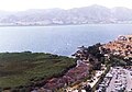
There are a number of lakes in Kurdistan. The eastern borders of Kurdistan ends with the Lake Urmia and the western borders with semi-contiguous Kurdish-inhabited regions on the Mediterranean shore. Lake Van is the world's fourth largest non-saline body of water by volume. The Zarivar Lake around Mariwan as well as Lake Dukan around the city of Sulaymaniyah are considerable touristic sites [20]
Underground resources
There are many oil and mineral resources in Kurdistan. KRG-controlled parts of Iraqi Kurdistan only by itself is estimated to have around 45bn barrels of oil reserves making it sixth largest in the world, mostly recently discovered and its extraction is said to begin within the first three months of 2007. These are excluding those of Kirkuk and Mosul, cities claimed by the KRG to be included in its territory. Albeit for a long time oil was extracted mainly in these two cities through Iraq by former Baath regime. Gas and associated gas reserves are in excess of 100 TCF. Other underground resources that exist in significant quantities in the region include copper, iron, zinc and limestone which is used to produce cement. The world's largest deposit of rock sulphur is located just southwest of Erbil (Hewlêr). Other important underground resources include coal, gold, marble etc.[21].
Climate
There are many rivers flowing and running through mountains of Kurdistan making it distinguished by its fertile lands, plentiful water, picturesque nature. The mountainous nature of Kurdistan, the difference of temperatures in its various parts, and its wealth of waters, make Kurdistan a land of agriculture and tourism. The climate of Kurdistan is harsh, because of its high altitude. There is a lot of snowfall in the high mountains. Precipitation varies between 200 to 400 mm a year in the plains, and between 700 to 3,000 mm a year on the high plateaux between mountain chains[16].
Views of Kurdistan
-
 Hills southwest of Sanandaj near the village of Kélane
 -

-
-
-
Saint Vartan near the city of Dohuk
-
 The Zagros Mountains from space
 -
-
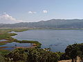
 Marivan countryside
 -
 The city of Sanandaj
 -
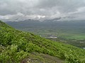
 The snow is still on the ground at the higher elevations on a mountain located near Arbil
 -
The Square of Liberty, the main square in Sanandaj


See also
- History of the Kurdish people
- Turkish Kurdistan
- Kurds in Turkey
- Iranian Kurdistan
- Iraqi Kurdistan
- Kurds in Syria
- Kurdistan Okrug
- Kurdish people
- List of Kurdish people
- Kurdish organisations
- Genetic insights into the background of the Kurds
- Yazidis
- Kurdish Jews
- Kurdish Christians
Modern Kurdish governments
- Kurdistan Regional Government (KRG) (1991–present)
- Republic of Kurdistan - (Mahabad) (1946)
- Republic of Ararat (1927–31)
- Kingdom of Kurdistan (1922–24)
Notes and references
- ^ "Kurdish Studies Program". Florida State University. Retrieved 2007-03-17.
- ^ Kurdistan, Encyclopaedia Britannica
- ^ Iraqi constitution, article 113, 1th
- ^ http://www.sacred-texts.com/bib/ebd/ebd340.htm
- ^ http://www.livius.org/cg-cm/chronicles/reading2.html
- ^ http://www.encislam.brill.nl/data/EncIslam/C4/COM-0544.html
- ^ William Gordon East, Oskar Hermann Khristian Spate, The Changing Map of Asia: A Political Geography, 1961 - 436 pages, p: 105
- ^ http://www.gutenberg.org/files/16167/16167-h/raw7a.htm
- ^ J. Bell, A System of Geography. Popular and Scientific (A Physical, Political, and Statistical Account of the World and Its Various Divisions), pp.133–4, Vol. IV, Fullarton & Co., Glasgow, 1832.
- ^ http://www.mazdapublishers.com/Sharafnama.htm
- ^ For a list of these entities see Kurdistan and its native Provincial subdivisions
- ^ C. Dahlman, The Political Geography of Kurdistan, Eurasian Geography and Economics, Vol.43, No.4, pp.271–299, 2002.
- ^ C. Dahlman, The Political Geography of Kurdistan, Eurasian Geography and Economics, Vol.43, No.4, pp.274
- ^ The map presented by the Kurdish League Delegation, March 1945
- ^ Kurdistan, Encyclopædia Britannica
- ^ a b c Kurdistan, Encyclopædia of Islam — currently offline
- ^ Geographic Distribution of Kurdish and other Iranic Languages,
- ^ Syria, CIA World Factbook
- ^ John Bulloch and Harvey Morris, No Friends but the Mountains: The Tragic History of the Kurds, ISBN 0-195-08075-0
- ^ a b Economy: Water, The Encyclopædia of Kurdistan
- ^ Official statements on the oil and gas sector in the Kurdistan region, Kurdistan Development Corporation
External links
- Kurdistan Regional Government (KRG) News, progress reports and reference material about Kurds, KRG and Kurdistan Region.
- The Kurdish Institute of Paris Provides news, bulletins, articles and conference information on the situation in Kurdistan.
- Official Investment Website of Kurdistan
- Essays on the Origins of Kurdish Nationalism, edited by Abbas Vali
- The Encyclopedia of Kurdistan
- Kurds, Kurdistan, The Encyclopaedia of Islam.
- Troubled Times - A Brief History Of Kurdistan
- A dozen maps of Kurdistan by GlobalSecurity.org
- "Turkey renames 'divisive' animals" BBC News 8 March2005
- A number of pictures from historical attractions in Kurdistan
- Calls for freedom make the jigsaw of Europe more complicated than ever (Kurdistan in 2010s) [1][2]